Mapleton, North Dakota

Last updated

Mapleton, North Dakota
Mapleton, North Dakota.jpg
A residential neighborhood in Mapleton
Motto(s): 
"A great place to branch out and grow"
ND Cass County Mapleton.svg
Location of Mapleton, North Dakota
Coordinates: 46°53′30″N97°03′12″W / 46.89167°N 97.05333°W / 46.89167; -97.05333
CountryUnited States
State North Dakota
County Cass
Founded1875
Government
  MayorAndrew Draeger[ citation needed ]
Area
[1]
  Total3.91 sq mi (10.13 km2)
  Land3.91 sq mi (10.13 km2)
  Water0.00 sq mi (0.00 km2)
Elevation
[2]
909 ft (277 m)
Population
 (2020)
  Total1,320
  Density337.51/sq mi (130.33/km2)
Time zone UTC-6 (CST)
  Summer (DST) UTC-5 (CDT)
ZIP code
58059
Area code 701
FIPS code 38-50580
GNIS feature ID1036149 [2]
Website mapletonnd.com

Mapleton is a city in Cass County, North Dakota, United States. It sits on the banks of the Maple River. The population was 1,320 at the 2020 census. [3] Mapleton serves as a bedroom community of the Fargo-Moorhead metropolitan area. The core cities are ten miles to the east of Mapleton.

Contents

History

Mapleton was platted in 1876, soon after the railroad was extended to that point. [4] The city took its name from the Maple River. [5] A post office has been in operation at Mapleton since 1875. [6]

Geography

According to the United States Census Bureau, the city has a total area of 4.00 square miles (10.36 km2), all land. [7]

Demographics

Historical population
CensusPop.Note
1890 119
1900 322170.6%
1910 207−35.7%
1920 198−4.3%
1930 195−1.5%
1940 180−7.7%
1950 169−6.1%
1960 1806.5%
1970 21921.7%
1980 30639.7%
1990 682122.9%
2000 606−11.1%
2010 76225.7%
2020 1,32073.2%
2021 (est.)1,374 [8] 4.1%
U.S. Decennial Census [9]
2020 Census [3]

2010 census

As of the census [10] of 2010, there were 762 people, 248 households, and 216 families living in the city. The population density was 190.5 inhabitants per square mile (73.6/km2). There were 264 housing units at an average density of 66.0 per square mile (25.5/km2). The racial makeup of the city was 94.4% White, 3.4% African American, 0.4% Native American, 0.9% from other races, and 0.9% from two or more races. Hispanic or Latino of any race were 3.5% of the population.

There were 248 households, of which 51.2% had children under the age of 18 living with them, 74.6% were married couples living together, 7.3% had a female householder with no husband present, 5.2% had a male householder with no wife present, and 12.9% were non-families. 8.5% of all households were made up of individuals, and 1.2% had someone living alone who was 65 years of age or older. The average household size was 3.07 and the average family size was 3.22.

The median age in the city was 30.4 years. 32.4% of residents were under the age of 18; 7.7% were between the ages of 18 and 24; 31.7% were from 25 to 44; 26% were from 45 to 64; and 2.4% were 65 years of age or older. The gender makeup of the city was 50.8% male and 49.2% female.

2000 census

As of the census of 2000, there were 606 people, 191 households, and 160 families living in the city. The population density was 151.4 inhabitants per square mile (58.5/km2). There were 193 housing units at an average density of 48.2 per square mile (18.6/km2). The racial makeup of the city was 98.18% White, 0.17% African American, 1.49% from other races, and 0.17% from two or more races. Hispanic or Latino of any race were 1.98% of the population.

There were 191 households, out of which 56.5% had children under the age of 18 living with them, 72.8% were married couples living together, 7.3% had a female householder with no husband present, and 16.2% were non-families. 12.6% of all households were made up of individuals, and 1.6% had someone living alone who was 65 years of age or older. The average household size was 3.17 and the average family size was 3.51.

In the city, the population was spread out, with 35.8% under the age of 18, 8.7% from 18 to 24, 35.0% from 25 to 44, 17.8% from 45 to 64, and 2.6% who were 65 years of age or older. The median age was 29 years. For every 100 females, there were 102.0 males. For every 100 females age 18 and over, there were 108.0 males.

The median income for a household in the city was $39,038, and the median income for a family was $42,750. Males had a median income of $28,875 versus $19,500 for females. The per capita income for the city was $12,900. About 5.7% of families and 6.0% of the population were below the poverty line, including 7.7% of those under age 18 and 21.4% of those age 65 or over.

Notable people

Climate

This climatic region is typified by large seasonal temperature differences, with warm to hot (and often humid) summers and cold (sometimes severely cold) winters. According to the Köppen Climate Classification system, Mapleton has a humid continental climate, abbreviated "Dfb" on climate maps. [11]

Related Research Articles

<span class="mw-page-title-main">Mapleton, Kansas</span> City in Kansas, United States

Mapleton is a city in Bourbon County, Kansas, United States. As of the 2020 census, the population of the city was 96.

<span class="mw-page-title-main">Mapleton, Maine</span> Town in the state of Maine, United States

Mapleton is a town in Aroostook County, Maine, United States. The population was 1,886 at the 2020 census.

<span class="mw-page-title-main">Alice, North Dakota</span> City in North Dakota, United States

Alice is a city in Cass County, North Dakota, United States. The population was 41 at the 2020 census.

<span class="mw-page-title-main">Argusville, North Dakota</span> City in North Dakota, United States

Argusville is a city in Cass County, North Dakota, United States. The population was 480 at the 2020 census. Increasing from 147 a decade earlier due to a huge housing boom from 2004 to 2008. Argusville was founded in 1881.

<span class="mw-page-title-main">Arthur, North Dakota</span> City in North Dakota, United States

Arthur is a city in Cass County, North Dakota, United States. The population was 328 at the 2020 census.

<span class="mw-page-title-main">Ayr, North Dakota</span> City in North Dakota, United States

Ayr is a city in Cass County, North Dakota, United States. The population was 11 at the 2020 census. Ayr was founded in 1883.

<span class="mw-page-title-main">Briarwood, North Dakota</span> City in North Dakota, United States

Briarwood is a city in Cass County, North Dakota, United States. The population was 57 at the 2020 census. Briarwood was founded in 1973. It is a suburb directly adjacent to the city of Fargo.

<span class="mw-page-title-main">Buffalo, North Dakota</span> City in North Dakota, United States

Buffalo is a city in Cass County, North Dakota, United States. The population was 195 at the 2020 census. Buffalo was founded in 1878.

<span class="mw-page-title-main">Davenport, North Dakota</span> City in North Dakota, United States

Davenport is a city in Cass County, North Dakota, United States. The population was 256 at the 2020 census. Davenport was founded in 1882.

<span class="mw-page-title-main">Frontier, North Dakota</span> City in North Dakota, United States

Frontier is a city in Cass County, North Dakota, United States. The population was 195 at the 2020 census. Frontier is located south of the city of Fargo and is located roughly six miles southwest of that city's downtown. Frontier was founded in 1976. Since Frontier's founding, the adjacent city of Fargo has grown to the point where it almost completely encompasses Frontier's city limits. Only a small gap on the city's southwest corner keeps Frontier from being a complete enclave community within Fargo's border.

<span class="mw-page-title-main">Gardner, North Dakota</span> City in North Dakota, United States

Gardner is a city in Cass County, North Dakota, United States. The population was 129 at the 2020 census.

<span class="mw-page-title-main">Harwood, North Dakota</span> City in North Dakota, United States

Harwood is a city in Cass County, North Dakota, United States. The population was 794 at the 2020 census. It has become a bedroom community of the nearby Fargo-Moorhead area. Harwood was founded in 1881.

<span class="mw-page-title-main">Horace, North Dakota</span> City in North Dakota, United States

Horace is a city in Cass County, North Dakota, United States. As of the 2020 census, the population was 3,085.

<span class="mw-page-title-main">Kindred, North Dakota</span> City in North Dakota, United States

Kindred is a city in Cass County, North Dakota, United States. The population was 889 at the time of the 2020 census. Kindred primarily serves as a bedroom community for Fargo, located about 25 miles to the southwest.

<span class="mw-page-title-main">Leonard, North Dakota</span> City in North Dakota, United States

Leonard is a city in Cass County, North Dakota, United States. The population was 248 at the 2020 census. Leonard was founded in 1881.

<span class="mw-page-title-main">North River, North Dakota</span> City in North Dakota, United States

North River is a city in Cass County, North Dakota, United States. The population was 55 at the 2020 census. North River was founded in 1973. It is a suburb/bedroom community directly adjacent to the city of Fargo.

<span class="mw-page-title-main">Oxbow, North Dakota</span> City in North Dakota, United States

Oxbow is a city in Cass County, North Dakota, United States. The population was 381 at the 2020 census. It is an upscale bedroom community located 15 miles (24 km) south of Fargo. It was incorporated as a city October 25, 1988.

<span class="mw-page-title-main">Page, North Dakota</span> City in North Dakota, United States

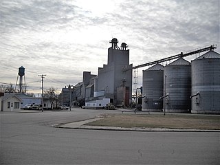
Page is a city in Cass County, North Dakota, United States. The population was 190 at the 2020 census. Page was founded in 1882.

<span class="mw-page-title-main">Prairie Rose, North Dakota</span> City in North Dakota, United States

Prairie Rose is a city in Cass County, North Dakota, United States. The population was 56 at the 2020 census. The city is an enclave suburb of Fargo. Prairie Rose was founded in 1975. There are 21 homes in the city.

<span class="mw-page-title-main">Tower City, North Dakota</span> City in North Dakota, United States

Tower City is a city in Barnes and Cass counties in the State of North Dakota. The population was 268 at the 2020 census.

References

  1. "ArcGIS REST Services Directory". United States Census Bureau. Retrieved September 20, 2022.
  2. 1 2 U.S. Geological Survey Geographic Names Information System: Mapleton, North Dakota
  3. 1 2 "Explore Census Data". United States Census Bureau . Retrieved May 17, 2022.
  4. Hoheisel, Tim; Nielsen, Andrew R. (2007). Cass County. Arcadia Publishing. p. 48. ISBN   978-0-7385-4145-7.
  5. Federal Writers' Project (1938). North Dakota, a Guide to the Northern Prairie State. WPA. p. 278. ISBN   978-1-62376-033-5.
  6. "Cass County". Jim Forte Postal History. Retrieved October 22, 2015.
  7. "US Gazetteer files 2010". United States Census Bureau. Archived from the original on January 12, 2012. Retrieved June 14, 2012.
  8. "City and Town Population Totals: 2020-2021". United States Census Bureau. June 16, 2022. Retrieved June 18, 2022.
  9. United States Census Bureau. "Census of Population and Housing" . Retrieved July 21, 2013.
  10. "U.S. Census website". United States Census Bureau . Retrieved June 14, 2012.
  11. Climate Summary for Mapleton, North Dakota