Kitsap County is located in the U.S. state of Washington. As of the 2020 census, its population was 275,611. Its county seat is Port Orchard; its largest city is Bremerton. The county, formed out of King County and Jefferson County on January 16, 1857, is named for Chief Kitsap of the Suquamish Tribe. Originally named Slaughter County, it was soon renamed.

Navy Yard City is a census-designated place (CDP) in Kitsap County, Washington, United States. The population was 2,759 at the 2020 census.

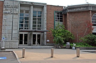
Port Orchard is a city in and the county seat of Kitsap County, Washington, United States. It is located 13 miles (21 km) due west of West Seattle and is connected to Seattle and Vashon Island via the Washington State Ferries run to Southworth. It is named after Port Orchard, the strait that separates Bainbridge Island from the Kitsap Peninsula.
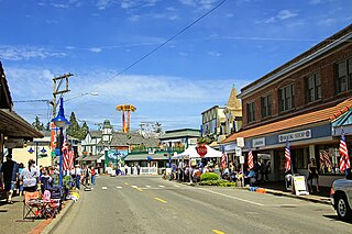
Poulsbo is a city on Liberty Bay in Kitsap County, Washington, United States. It is the smallest of the four cities in Kitsap County. The population was 11,970 at the 2020 census and an estimated 10,927 in 2018.
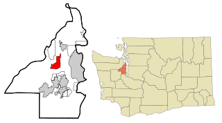
Silverdale is an unincorporated community in Kitsap County, Washington, in the United States. Despite many failed attempts at incorporation, Silverdale has not become a city. The population was 20,733 at the 2020 census. For statistical purposes, the United States Census Bureau has defined Silverdale as a census-designated place (CDP).

Tracyton is a census-designated place (CDP) in Kitsap County, Washington, United States. Its population was 5,967 at the 2020 census. It was named for 19th century Secretary of the Navy Benjamin F. Tracy.
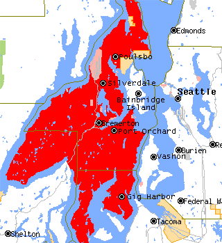
The Kitsap Peninsula lies west of Seattle across Puget Sound, in Washington state in the Pacific Northwest. Hood Canal separates the peninsula from the Olympic Peninsula on its west side. The peninsula, a.k.a. "Kitsap", encompasses all of Kitsap County except Bainbridge and Blake Islands, as well as the northeastern part of Mason County and the northwestern part of Pierce County. The highest point on the Kitsap Peninsula is Gold Mountain. The U.S. Navy's Puget Sound Naval Shipyard, and Naval Base Kitsap are on the peninsula. Its main city is Bremerton.
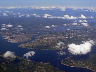
Port Orchard, part of Washington state's Puget Sound, is the strait that separates Bainbridge Island on the east from the Kitsap Peninsula on the west. It extends from Liberty Bay and Agate Pass in the north to Sinclair Inlet and Rich Passage in the south. It was named in May 1792 by George Vancouver after Harry Masterman Orchard, ship's clerk of Vancouver's ship Discovery.

State Route 3 (SR 3) is a 59.81-mile-long (96.25 km) state highway in the U.S. state of Washington, serving the Kitsap Peninsula in Mason and Kitsap counties. The highway begins at U.S. Route 101 (US 101) south of Shelton and travels northeast onto the Kitsap Peninsula through Belfair to Gorst, where it intersects SR 16 and begins its freeway. SR 3 travels west of Bremerton, Silverdale and Poulsbo before it terminates at the eastern end of the Hood Canal Bridge, signed as SR 104. The highway is designated as a Strategic Highway Network (STRAHNET) corridor under the National Highway System as the main thoroughfare connecting both parts of Naval Base Kitsap and is also part of the Highways of Statewide Significance program.

The Suquamish Indian Tribe of the Port Madison Reservation is a federally recognized tribe and Indian reservation in the U.S. state of Washington.

Sinclair Inlet is a shallow embayment in the western part of Puget Sound in Kitsap County, Washington, USA. It has a maximum depth of 20 meters. It is the southwestern extension of Port Orchard, and it touches the shores of three of Kitsap County's four incorporated cities: Bremerton, Bainbridge Island, and Port Orchard. It is connected to Dyes Inlet by the Port Washington Narrows and to Puget Sound by Rich Passage. It was named by United States Navy explorer Charles Wilkes for George T. Sinclair, acting master of one of his ship's crews. The Puget Sound Naval Shipyard is located on the north shore of Sinclair Inlet.
Liberty Bay is a narrow inlet extending about 4 miles in a northerly direction from the northwest part of Port Orchard, adjacent to the Kitsap Peninsula in Western Washington.
Chico is an unincorporated community and census-designated place (CDP) in Kitsap County, Washington, United States. Named in 1889 for a local Indian, Chico is located on the Dyes Inlet waterfront, south of Silverdale. At the 2020 census the community had a population of 2,723.

Phinney Bay is a small bay, approximately 0.8 miles long, off the northwest end of the Port Washington Narrows on the Kitsap Peninsula in Kitsap County, Washington, USA. Adjacent to Dyes Inlet, the city of Bremerton is south of the bay and East Bremerton north of the bay. Rocky Point makes up the west shore. The east side of Phinney Bay is the only part of the bay that directly borders Bremerton city limits, with the majority of the shoreline being a part of the Rocky Point census-designated place in unincorporated Kitsap County. Nearby bays include Mud Bay, Ostrich Bay, and Oyster Bay.
The Manette Peninsula is a headland that is part of the larger Kitsap Peninsula, located on the eastern flank of the Kitsap Peninsula, in western Washington, United States.

Bangor Base is a census-designated place (CDP) in Kitsap County, Washington, within U.S. Naval Base Kitsap on the Kitsap Peninsula. Its population was 5,482 at the 2020 census.

Sherwood Creek is a creek in Mason County, Washington fed by Mason Lake. It runs through the small town of Allyn, Washington, before releasing into the Case Inlet at the base of the Kitsap Peninsula.It is a popular local Picnic and camping spot.
Central Kitsap School District 401 is a public school district in Kitsap County, Washington, United States. It serves unincorporated portions of the county, including the community of Silverdale, and portions of the City of Bremerton. As of June 2014, the district has an enrollment of 11,091 students. Approximately one-quarter of students are from military families, and one half are from families economically dependent on the US Navy. It consists of CK High and Middle school, Klahowya, and other schools like Ridgetop or Fairview
Rocky Point is a census-designated place (CDP) in Kitsap County, Washington, United States.

Clear Creek Trail is an urban trail in Silverdale, Washington, "at once in the suburbs and simultaneously immersed in the natural world". In a 2011 book by Mountaineers Books, it was reported to be over seven miles long. The trail extends along Clear Creek from its uplands near the Naval Base Kitsap-Bangor Trigger Avenue gate on State Route 3 to the creek's estuary at Dyes Inlet.
