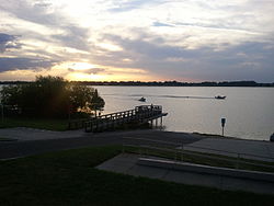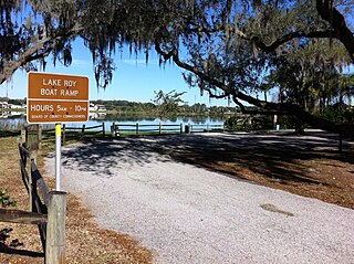
Lake Roy is a natural freshwater lake inside the city of Winter Haven, Florida. It has a 74.17-acre (300,200 m2) surface area and is located on the south side of Cypress Gardens Boulevard. The lake once had a larger surface area, but when Cypress Gardens Boulevard was upgraded it ran over some of the northern part of Lake Roy; this part had been filled so the road could be rerouted. A small part of the old lakebed is north of the street, but is more of a retention pond now, for the most part remaining dry. The lake is of an irregular shape. Lake Roy is connected by a canal on its southwest side to Lake Lulu and indirectly from there to more than twenty other area lakes. These lakes are linked by canals and are known locally as the Chain of Lakes. Most of the shore of Lake Roy is bordered by residential housing. Residential areas circle from the southeast around to the northwest side of the lake. Along Cypress Gardens Boulevard on the northwest are businesses and a hotel, Lake Roy Beach Inn, is on this street at the northeast corner of the lake.
Lake Conine is a natural freshwater lake on the north side of Winter Haven, Florida. The lake is not within the city limits, but is almost entirely surrounded by the city of Winter Haven. Lake Conine is almost as often called Lake Connie as it is called Lake Conine. In fact, the Fishing Works website site has two listings calling this lake the former name and one calling it the latter. Lake Conine is bounded on the north and southwest by residential areas. On the west and southeast are woods. On the east the lake is bordered by SR 544. Lake Conine has a 237-acre (960,000 m2) surface area and it is shaped somewhat like a teardrop.
Lake Summit is a natural freshwater lake in Winter Haven, Florida. It has a 65.97-acre (267,000 m2) surface area and is somewhat oval in shape. It has two small coves on its north side. This lake is surrounded by residences around most of its perimeter. It has a public park, Lake Summit Park, on part of its west side, and Legoland Florida's water park is on its southeast shore. A boat canal on the south side of Lake Summit leads to Lake Eloise.
Lake Mariam is roughly oval in shape and is on the northeast side of Winter Haven, Florida. The Polk County Water Atlas says sometimes the lake is known as Lake Marion, but a different Lake Marion is also in Polk County, Florida, where Lake Mariam is located. It has a surface area of 200 acres (809,371 m2) and is bordered on the west side, most of the south side and part of the north side by residential areas. Brandywine Health Care Center, a nursing home, is a block north of the lake. On the northwest and southwest Lake Mariam is bordered by woods and on most of the east side of the lake are woods and pastureland. On the lake's southeast side is a swampy area.
Lake Martha, oval in shape, is in the west-central part of Winter Haven, Florida. Lake Martha Drive surrounds two-thirds of the lake's perimeter. Lake Martha has a 84.38-acre (341,500 m2) surface area. On the northeast is a public park and boat ramp and across the street from this park is the Winter Haven campus of Polk State College. Winter Haven Hospital is on the lake's west side and a public park is at the southwest side of the lake. Residential housing surrounds the rest of the lake.
Lake Florence is a tear-shaped natural freshwater lake in east-central Winter Haven, Florida. This lake has a 72.59-acre (293,800 m2) surface area. It is surrounded on all but its east and northeast sides by residential areas. On the east it is bordered by woods and on the northeast it is bordered by a citrus grove.
Lake Daisy is a natural freshwater lake on the east side of Winter Haven, Florida. It has a somewhat oval shape and has a 131-acre (530,000 m2) surface area. On all but its northeast shore it is bordered by residential areas. On the northeast is a residential area that has been only about one-tenth completed. On the northwest of Lake Daisy is a short canal that connects it to the tiny Lake Doll.

Lake Howard is a fresh water lake, located in Winter Haven, Florida. The lake is part of the headwaters of the Peace River watershed. Lake Howard is a prominent lake in Winter Haven's Chain of Lakes. Lake Howard is on the southern chain of lakes. It is connected to Lake Cannon, to the north-west, and Lake May, to the south-east. Lake Howard has a surface area of 624 acres. It has a mean depth of 10.9 feet (3.3 m), and maximum depth of 18.7 feet (5.7 m).
Lake McLeod, sometimes also called McLeod Lake, is somewhat oval in shape. This lake is a natural freshwater lake with a 410-acre (1,700,000 m2) surface area. Lake McLeod is bordered on the north by the town of Eagle Lake, Florida. Here it is bordered by residential areas. It is bordered on the northeast and east the lake is bordered by residences. On the south it is bordered by grassland and citrus orchards.
Lake Shipp is almost round in shape. This lake is a natural freshwater lake with a 276-acre (1,120,000 m2) surface area. This lake is bordered on the north, northwest and the southwest sides by residential areas. On the east and part of the southeast are warehouses and business buildings. William G. Roe Park is on the southeast shore and Sertoma Park, officially called Lake Shipp Park, is on the west side of Lake Shipp.
Lake Smart is a round natural freshwater lake, with a semicircular cove on its northwest side, on the northeast side of Winter Haven, Florida. Lake Smart has a water area of 277-acre (1,120,000 m2). This lake is mostly surrounded by woods and citrus groves. On its north and west sides it is bordered by residential developments. On the northwest Florida State Route 544 runs along Lake Smart's cove.
Lake May, a wedge-shaped lake, is a natural freshwater lake in southwest Winter Haven, Florida. This lake has a 49.07-acre (198,600 m2) surface area. It is bounded on the east and northeast by vacant land, on the northwest by commercial property, on the west and most of the south by vacant land and on the east and southeast by more commercial property. Much of the shore around the lake is lined by swampy areas.
Lake Fannie, is a natural freshwater lake on the northeast side of Winter Haven, Florida. This lake has an 802-acre (3,250,000 m2) surface area. Much of its shoreline area is swamplike, but the rest of the lake is free of surface vegetation. Lake Idyl is bordered on the north by Polk County Road 544, on part of the east side by a residential area and on most of the rest of its shoreline by woods.
Lake Cannon, an almost round lake, has a surface area of 333-acre (1,350,000 m2). Lake Cannon is in a highly urbanized area. On the north shore is a some vacant land and the Boys Club is on the northeast shore. The rest of the lake is surrounded by residential areas. About 300 feet (91 m) to the lake's east is Lake Mirror and 500 feet (150 m) to the southeast is Lake Howard.
Lake Hartridge, with somewhat of a figure eight shape, has a surface area of 433-acre (1,750,000 m2). This lake is on the north side of Winter Haven, Florida. Most of the lake's west shore is bordered by residential areas. The northwest shore is bordered by woods. The north shore is bordered woods and clearings. The northeast is bordered by more clearings. The east central and southeast shores are bordered by woods and a few residences. At the very southeast corner is Aldora Park, a small public park. The south shore is bordered by a large church. On the southwest shore is Lake Hartridge Nature Park, a public park.
Lake Jessie, with somewhat of an oval shape, has a surface area of 189-acre (760,000 m2). This lake is on the northwest side of Winter Haven, Florida, and is just east of Auburndale, Florida. Residential areas border this lake from the northwest shore all the way south along the west shore, ending where the south shore of the lake meets the east shore of the lake. At this point a canal separates the residences from some woods on the southeast shore of Lake Jessie. These woods are on the edge of Winter Haven Municipal Airport. Airport property occupies the entire east and northeast shores of the lake. Jack Brown's Seaplane Base, on the northeast shore and a part of the airport uses the northeast shore of Lake Jessie for seaplane takeoffs and landings. Most of the north shore of the lake is bordered by more woods.
Lake Rochelle, of which the main body is oval-shaped, has a smaller oval-shaped cove on its east end. This lake has a surface area of 580-acre (2,300,000 m2). The lake is located just north of Winter Haven, Florida, but is located entirely within the city limits of Lake Alfred, Florida, the main part of which is on the lake's northwest side. On that side US Highway 92 is just beyond the lake's shore. Most of the north and west sides of Lake Rochelle are bordered by woods. The east and south sides are bordered by residences and grassland.
Lake Hunter, a pear-shaped lake, has a surface area of 93 acres (380,000 m2). This lake is inside Lakeland, Florida, and the area surrounding it is completely urbanized. It is bordered on the northeast by residences and the Lake Hunter Boat Ramp. On the lakes's north and west it is bordered by Sikes Boulevard and on the south and southeast by Lake Hunter Drive. The Lake Hunter Terrace Historic District borders the lake along Sikes Boulevard.
Crystal Lake, one of seven Crystal Lakes in Polk County, Florida,is a somewhat oval-shaped lake. It has a surface area of 27.58 acres (111,600 m2). This lake is inside Lakeland, Florida, and most of the area surrounding it is completely urbanized. It is bounded on the east by county road 659 and on the north by Crystal Lake Park and North Crystal Lake Drive. On the west it is bordered by homes. On the southwest it is bordered by South Crystal Lake Drive and on the southeast it is bounded by more homes.