
The Turks and Caicos Islands are a British Overseas Territory consisting of the larger Caicos Islands and smaller Turks Islands, two groups of tropical islands in the Lucayan Archipelago of the Atlantic Ocean and northern West Indies. They are known primarily for tourism and as an offshore financial centre. The resident population in July 2021 was put at 57,196, making it the third-largest of the British overseas territories by population.

The United Kingdom is a sovereign state located off the north-western coast of continental Europe. With a total area of approximately 248,532 square kilometres (95,960 sq mi), the UK occupies the major part of the British Isles archipelago and includes the island of Great Britain, the north-eastern one-sixth of the island of Ireland and many smaller surrounding islands. It is the world's 7th largest island country. The mainland areas lie between latitudes 49°N and 59°N, and longitudes 8°W to 2°E. The Royal Observatory, Greenwich, in south-east London, is the defining point of the Prime Meridian.

Bonaire is a Dutch island in the Leeward Antilles in the Caribbean Sea. Its capital is the port of Kralendijk, on the west (leeward) coast of the island. Aruba, Bonaire and Curaçao form the ABC islands, 80 km off the coast of Venezuela. Unlike much of the Caribbean region, the ABC islands lie outside Hurricane Alley. The islands have an arid climate that attracts visitors seeking warm, sunny weather all year round. Bonaire is a popular snorkeling and scuba diving destination because of its multiple shore diving sites and easy access to the island's fringing reefs.
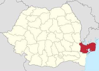
Tulcea County is a county (județ) of Romania, in the historical region Dobruja, with the capital city at Tulcea. It includes in its northeast corner the large and thinly-populated estuary of the Danube.

The Frisian Islands, also known as the Wadden Islands or the Wadden Sea Islands, form an archipelago at the eastern edge of the North Sea in northwestern Europe, stretching from the northwest of the Netherlands through Germany to the west of Denmark. The islands shield the mudflat region of the Wadden Sea from the North Sea.
Grand Turk Island is an island in the Turks and Caicos Islands. It is the largest island in the Turks Islands with 18 km2 (6.9 sq mi). Grand Turk contains the territory's capital, Cockburn Town, and the JAGS McCartney International Airport. The island is the administrative, historic, cultural and financial center of the territory and has the second-largest population of the islands at approximately 4,831 people in 2012.

Ometepe is an island formed by two volcanoes rising out of Lake Nicaragua, located in the Rivas Department of the Republic of Nicaragua. Its name derives from the Nahuatl words ome (two) and tepetl (mountain), meaning "two mountains". It is the largest island in Lake Nicaragua.

Mayaguana is the easternmost island and district of The Bahamas. Its population was 277 in the 2010 census. It has an area of about 280 km2 (110 sq mi).

Providenciales is an island in the northwest Caicos Islands, part of the Turks and Caicos Islands, a British Overseas Territory. The island has an area of 98 km2 (38 sq mi) and a 2012 Census population of 23,769. Providenciales is the third largest island in the Turks and Caicos in area, and is home to a large majority of the population of the Turks and Caicos Islands.
USS Chippewa was a brig built in 1815 at Warren, Rhode Island, under the direction of Commodore Oliver Perry, and sent to New York City to be outfitted and manned. Chippewa sailed from Boston, Massachusetts, 3 July 1815, with Lieutenant George C. Read in command, as a part of a squadron under the command of Commodore William Bainbridge. It was intended to go to the Mediterranean for use against the Barbary pirates based in North Africa.

Ua Huka is one of the Marquesas Islands, in French Polynesia, an overseas territory of France in the Pacific Ocean. It is situated in the northern group of the archipelago, approximately 25 mi (40 km) to the east of Nuku Hiva, at 8°54′S139°33′W.

South Caicos is the seventh-largest island in the Turks and Caicos archipelago, with a land area of 21.2 square kilometres. South Caicos is known for excellent fishing, both deep-sea and bone fishing, and scuba diving. South Caicos was formerly a salt exporter, the island still hosts a network of salt pans as a reminder of the industry. Today, the island's main income is derived from small-scale commercial fishing.

North Caicos is the second-largest island in the Turks and Caicos Islands. To the west, the Caicos Cays link to Providenciales. To the east, it is separated from Middle Caicos by Juniper Hole, a narrow passage that can accommodate only small boats. A 1600-m (1-mile) causeway connects North Caicos to Middle Caicos.

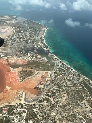
Middle Caicos is the largest island in the Turks and Caicos Islands. To the west, it is separated from North Caicos by Juniper Hole, and to the east, from East Caicos by Lorimer Creek, both narrow passages that can accommodate only small boats. The island is known for its extensive system of caves and its significant Lucayan Indian archaeological sites. The island is connected to North Caicos via a causeway. Middle Caicos was previously called Grand Caicos, although this name is not used today.

Koufonisia is a former community in the Cyclades, Greece. Since the 2011 local government reform it is part of the municipality Naxos and Lesser Cyclades, of which it is a municipal unit. The municipal unit has an area of 26.025 km2.

Salt Cay is the second largest of the Turks Islands, one of the two island groups forming of the British territory of the Turks and Caicos Islands in the Caribbean. Its area is 6.74 square kilometres. The size of the district, which also includes some unpopulated islands like Cotton Cay nearby, is 9.1 square kilometres. The population is 108, all in the district capital Balfour Town, established in 1673, on the west coast.
Trouvadore was a Spanish slave ship that was shipwrecked in 1841 near East Caicos in the course of a run transporting Africans to be illegally sold to the sugarcane plantations in Cuba. As the United Kingdom had a treaty with Spain prohibiting the international slave trade and had abolished slavery in its colonies in 1833, it freed the 192 slaves who survived the wreck. Individuals and families, a total of 168 Africans, were placed with salt proprietors for apprenticeships in the Turks and Caicos Islands; the remaining 24 Africans were settled in Nassau.
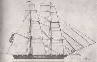
USS Onkahye was a topsail schooner of the United States Navy. A unique ship in the American Navy under sail, the vessel occupied a significant place in ship development, being the only converted sailing yacht to serve on a distant station before the American Civil War. Its design was influential and it is considered the model for modern American sailing yachts.

The Fish Ponds and Crossing Place Trail Important Bird Area is a 1024 ha tract of land on the island of Middle Caicos in the Turks and Caicos Islands, a British Overseas Territory in the Lucayan Archipelago of the western Atlantic Ocean. It forms one of the territory's Important Bird Areas (IBAs).

The East Lake Abert Archeological District is an area in Lake County, Oregon, United States, that features numerous prehistoric camp sites and petroglyphs. It is located along the eastern shore of Lake Abert on land administered by the Bureau of Land Management and the Oregon Department of Transportation. The site includes stone-walled house pits and prehistoric rock art made by ancient Native Americans who occupied the site for approximately 11,000 years. Because of its unique archaeological and cultural significance, the East Lake Abert Archaeological District was listed on the National Register of Historic Places in 1978.


