
Enola is a census-designated place (CDP) located along the Susquehanna River in East Pennsboro Township, Cumberland County, Pennsylvania, United States. The population was 6,111 at the 2010 census. Norfolk Southern operates Enola Yard, a large rail yard and locomotive shop in Enola. It is situated in Cumberland County, directly across the Susquehanna River from Harrisburg and is part of the Harrisburg–Carlisle metropolitan statistical area.
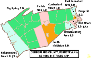
The Big Spring School District is a midsized, rural, public school district which serves the residents of the Borough of Newville and Cooke Township, Lower Frankford Township, Lower Mifflin Township, North Newton Township, Penn Township, South Newton Township, Upper Frankford Township, Upper Mifflin Township and West Pennsboro Township in Cumberland County, Pennsylvania. Big Spring School District encompasses approximately 198 square miles (510 km2). By 2010, the district's population increased to 19,098 people. According to 2008 local census data it served a resident population of 18,665. The educational attainment levels for the Big Spring School District population were 84.3% high school graduates and 14% college graduates. The district is one of the 500 public school districts of Pennsylvania.

The Gettysburg Area School District is a mid-sized, rural, public school district which serves students in a 185-square-mile (480 km2) area of Adams County, Pennsylvania. The district includes: Gettysburg Borough, as well as Cumberland, Freedom, Highland, Franklin and parts of Mt. Joy and Straban Townships. According to 2000 federal census data, Gettysburg Area School District served a resident population of 26,205 people. By 2010, the district's population increased to 27,614 people. The educational attainment levels for the Gettysburg Area School District population were 87.4% high school graduates and 27.4% college graduates. The district is one of the 500 public school districts of Pennsylvania.

Cumberland County is a county in the Commonwealth of Pennsylvania. As of the 2020 census, the population was 259,469. Its county seat is Carlisle.
The Cumberland Valley School District is a large, rural and suburban public school district located in Central Pennsylvania. It covers Hampden Township, Monroe Township, Middlesex Township and Silver Spring Township in Cumberland County, Pennsylvania. According to 2000 federal census data, it served a resident population of 46,926. By 2010, the district's population increased to 54,670 people. In 2009, the district residents’ per capita income was $28,440, while the median family income was $66,515. In the Commonwealth, the median family income was $49,501 and the United States median family income was $49,445, in 2010. By 2013, the median household income in the United States rose to $52,100.
South Middleton School District is a mid-sized, rural, public school district located in Boiling Springs, Pennsylvania. It also serves residents of South Middleton Township. South Middleton School District encompasses approximately 51 square miles (130 km2). South Middleton School District serves grades (K–12). According to 2000 federal census data, it served a resident population of 12,939. By 2010 the population had risen to 14,695 residents. The educational attainment levels for the school district population were 92.9% high school graduates and 33.1% college graduates.

The Cocalico School District is a small, suburban public school district located in Lancaster County, Pennsylvania in the United States. The school district covers the boroughs of Denver and Adamstown and East Cocalico Township and West Cocalico Township. Cocalico School District encompasses approximately 51 square miles (130 km2) square miles. According to 2008 local census data, it served a resident population of 21,095 people. Per 2011, US Census Bureau data, it serves a resident population of 21,115 people. The educational attainment levels for the Cocalico School District population were 80.9% high school graduates and 16% college graduates. In 2009, the district residents’ per capita income was $20,736, while the median family income was $54,850. In the Commonwealth, the median family income was $49,501 and the United States median family income was $49,445, in 2010. In Lancaster County, the median household income was $54,765. By 2013, the median household income in the United States rose to $52,100.
The Camp Hill School District is a diminutive, suburban public school district serving the Borough of Camp Hill in Cumberland County, Pennsylvania At just 2 square miles (5.2 km2), Camp Hill is the smallest school district in Cumberland County and it is one of the smallest in the Commonwealth of Pennsylvania. The district is so small it does not offer school bus transportation and instead encourages students to walk. According to the July 1, 2007 local tax rolls, it serves a resident population of 6,367. By 2010, the district's population increased to 7,903 people. The total median age was 43.0 years compared to 40.1 years in Pennsylvania. The educational attainment levels for the population 25 and over were 96.8% high school graduates and 47.6% college graduates. In 2009, Camp Hill School District residents' per capita income was $28,256, while the median family income was $303,000. Per district officials, it served 1,233 pupils in 2021.

Middletown Area School District is a small, suburban, public school district located in Middletown, Pennsylvania serving students in a portion of southern Dauphin County. The district includes the boroughs of Middletown and Royalton and Lower Swatara Township in Dauphin County. Middletown Area School District encompasses approximately 17 square miles (44 km2). According to 2000 federal census data, it served a resident population of 18,355. By 2010, the district's population declined to 18,084 people. The educational attainment levels for the Middletown Area School District population were 79.2% high school graduates and 13.2% college graduates. The district is one of twelve public school districts operating in Dauphin County and one of the 500 public school districts of Pennsylvania.
West Shore School District, is a large, suburban, public school district with its main office located in Lewisberry, Pennsylvania. This district serves students in eastern Cumberland County and northern York County. It serves the municipalities of Lemoyne, New Cumberland and Wormleysburg boroughs and Lower Allen Township in Cumberland County; Goldsboro and Lewisberry boroughs, Fairview Township and Newberry Township in York County. West Shore School District encompasses approximately 78 square miles (200 km2). According to 2000 federal census data, the district served a resident population of 57,960 people. By 2010, the district's population increased to 62,514 people.

The Carmichaels Area School District serves the Borough of Carmichaels and Cumberland Township in Greene County, Pennsylvania. The district encompasses approximately 39 square miles (100 km2). The district is one of the 500 public school districts of Pennsylvania and one of five public school districts in Greene County. According to 2000 federal census data, it served a resident population of 7,120. By 2010, the district's population declined to 7,098 people. In 2009, the district residents’ per capita income was $15,269, while the median family income was $36,276. In the Commonwealth, the median family income was $49,501 and the United States median family income was $49,445, in 2010. The educational attainment levels for the population 25 and over were 86.0% high school graduates and 18.6% college graduates.
Lower Dauphin School District is a midsized, suburban public school district located in central Pennsylvania. The district encompasses approximately 89 square miles (230 km2) and consists of Hummelstown, Pennsylvania, East Hanover Township, Pennsylvania, Londonderry Township, Dauphin County, Pennsylvania, South Hanover Township, Pennsylvania, and Conewago Township, Dauphin County, Pennsylvania. According to 2000 federal census data, the district served a resident population of 22,546. By 2010, the district's population increased to 24,747 people. The educational attainment levels for the district's population were 91.2% high school graduates and 28.2% college graduates. The district is one of the 500 public school districts of Pennsylvania.

The Greenwood School District is a small, rural, public school district which is located in Millerstown, Pennsylvania. The northernmost school district in Perry County, Pennsylvania, it is bordered to the north by the Juniata County School District, to the east by the Susquehanna River, to the south by the Newport School District, and to the west by the West Perry School District.
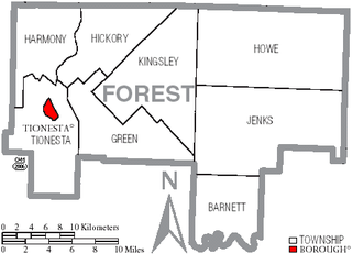
Forest Area School District is a small, rural, public school district in northwestern Pennsylvania. It is the public school entity for all of Forest County. It serves the communities of Marienville and Tionesta, along with a portion of President Township in Venango County and Millstone Township in Elk County. The district encompasses approximately 500 square miles (1,300 km2). According to 2000 federal census data, it serves a resident population of 4,946. By 2010, the District's population increased to 8,255 people. The educational attainment levels for the Forest Area School District population were 80.9% high school graduates and 9.8% college graduates. The district is one of the 500 public school districts of Pennsylvania.

The Bedford Area School District is a small, rural public school district located in southcentral Pennsylvania. It serves the Boroughs of Bedford, Hyndman, Manns Choice and Rainsburg and Bedford Township, Colerain Township, Cumberland Valley Township, Harrison Township, Londonderry Township and Snake Spring Township in Bedford County, Pennsylvania. Bedford Area School District encompasses approximately 292 square miles (760 km2). According to 2000 federal census data, it served a resident population of 16,890. By 2010, the district's population declined to 16,819 people. The educational attainment levels for the Bedford Area School District population were 84% high school graduates and 14% college graduates. The district is one of the 500 public school districts of Pennsylvania.

The Berwick Area School District is a midsized, rural, public school district. Berwick Area School District encompasses approximately 101 square miles (260 km2), spanning portions of two central Pennsylvania counties. In Columbia County it covers the Boroughs of Berwick and Briar Creek and Briar Creek Township. In Luzerne County it covers the Borough of Nescopeck and Hollenback Township, Nescopeck Township and Salem Township. According to 2000 federal census data, it served a resident population of 22,622. By 2010, the district's population had declined to 22,332 people. The educational attainment levels for the school district population were 82.1% high school graduates and 13.7% college graduates. The district is one of the 500 public school districts of Pennsylvania.
The Carlisle Area School District is a midsized, suburban, public school district that serves the boroughs of Carlisle and Mount Holly Springs and Dickinson Township and North Middleton Township in Cumberland County, Pennsylvania. Carlisle Area School District encompasses approximately 75 square miles (190 km2). According to 2000 federal census data, it serves a resident population of 34,794. in 2009, the residents' per capita income was $22,214, while the districts' median family income was $52,276.

The Tuscarora School District is a midsized, rural, public school district located in Franklin County, Pennsylvania. It serves: the borough of Mercersburg, as well as St. Thomas Township, Peters Township, Montgomery Township, and Warren Township. The district is one of the 500 public school districts of Pennsylvania. Tuscarora School District covers an area of 201 square miles (520 km2), stretching north–south from just south of 40 degrees north latitude to the Maryland border and from east of the 78 degree west longitude line to just west of Chambersburg, Pennsylvania. The district is primarily a rural agricultural area with a total population of approximately 17,000 people. Tuscarora, the name of the mountain on the western boundary, is derived from the Tuscarora Tribe of the Iroquois Confederation. The Tribe came north from the Carolinas about 1713 and settled for a time along the mountains. The name Tuscarora comes from the Indian name Skaruron or hemp gatherers. Conococheague, the name of the creek that flows through the district on its way from the Path Valley south to the Potomac River, is an Indian name from the Delaware Tribe meaning clear water.

The Juniata County School District is a rural, public school district located in Juniata County, Pennsylvania. The district is one of the 500 public school districts of Pennsylvania and one of seven county-wide school districts in the Commonwealth. The district encompasses approximately 372 square miles (960 km2). Juniata County School District serves residents in: Beale Township, Delaware Township, Fayette Township, Fermanagh Township, Lack Township, Milford Township, Monroe Township, Spruce Hill Township, Susquehanna Township, Turbett Township, Tuscarora Township and Walker Township. It also serves the residents of the following boroughs: Mifflin, Mifflintown, Port Royal, Thompsontown, East Salem, East Waterford, Mexico, McAlisterville and Richfield. According to 2000 federal census data, Juniata County School District served a resident population of 22,273 people. By 2013, the US Census reports that the Juniata County School District's resident population grew to 24,005 people. The educational attainment levels for the Juniata County School District population were 82.4% high school graduates and 11.2% college graduates. The district is one of the 500 public school districts of Pennsylvania.

The Riverside School District is a small, suburban public school district in Lackawanna County which formed in 1961. The school serves the boroughs of Moosic and Taylor, both suburbs of Scranton. Riverside School District encompasses approximately 12 square miles (31 km2) square miles. According to 2000 local census data, the district serves a resident population of 12,050. By 2010, the district's population declined to 11,978 people. The educational attainment levels for the school district population were 87% high school graduates and 21.7% college graduates.

