
The Louisiana Purchase was the acquisition of the Louisiana territory of New France by the United States from France in 1803. The U.S. paid fifty million francs ($11,250,000) and a cancellation of debts worth eighteen million francs ($3,750,000) for a total of sixty-eight million francs. The Louisiana territory included land from fifteen present U.S. states and two Canadian provinces. The territory contained land that forms Arkansas, Missouri, Iowa, Oklahoma, Kansas, and Nebraska; the portion of Minnesota west of the Mississippi River; a large portion of North Dakota; a large portion of South Dakota; the northeastern section of New Mexico; the northern portion of Texas; the area of Montana, Wyoming, and Colorado east of the Continental Divide; Louisiana west of the Mississippi River ; and small portions of land within the present Canadian provinces of Alberta and Saskatchewan. Its non-native population was around 60,000 inhabitants, of whom half were African slaves.

Pointe Coupee Parish,, is a parish located in the U.S. state of Louisiana. As of the 2010 census, the population was 22,802. The parish seat is New Roads.

East Baton Rouge Parish is the most populous parish in the U.S. state of Louisiana. As of the 2010 census, the population was 440,171. The parish seat is Baton Rouge, Louisiana's state capital.

Hammond is the largest city in Tangipahoa Parish, Louisiana, United States, located 45 miles (72 km) east of Baton Rouge and 45 miles (72 km) northwest of New Orleans. Its population was 20,019 in the 2010 census. Hammond is home to Southeastern Louisiana University and is the principal city of the Hammond Metropolitan Statistical Area, which includes all of Tangipahoa Parish.

West Florida was a region on the north shore of the Gulf of Mexico that underwent several boundary and sovereignty changes during its history. As its name suggests, it was formed out of the western part of former Spanish Florida, along with lands taken from French Louisiana; West Florida's capital was Pensacola. The colony included about 2/3 of what is now the Florida Panhandle, as well as parts of the modern U.S. states of Louisiana, Mississippi, and Alabama.

The Gulf Intracoastal Waterway is the portion of the Intracoastal Waterway located along the Gulf Coast of the United States. It is a navigable inland waterway running approximately 1,050 mi (1,690 km) from Carrabelle, Florida, to Brownsville, Texas.
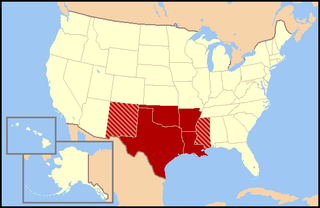
The South Central United States or South Central states is a region of the United States located in the south central part of the country. It evolved out of the Old Southwest, which originally was literally the western U.S. South, as can be seen in the now defunct Southwest Conference of the NCAA. The states of Arkansas, Louisiana, Oklahoma, and Texas are almost always considered the "core" of the region. As part of the East South Central States sub-group of the Census Bureau classification, Alabama, Mississippi, Tennessee and Kentucky are also frequently listed under the heading. At the highest extent, Kansas, and Missouri, may be included by some sources. All or parts these states are in the Central Time Zone. At different and changing points in time, all of the above states were/are considered part of the West in American history.

Perdido River, historically Rio Perdido (1763), is a 65.4-mile-long (105.3 km) river in the U.S. states of Alabama and Florida; the Perdido, a designated Outstanding Florida Waters river, forms part of the boundary between the two states along nearly its entire length and drains into the Gulf of Mexico. During the early 19th century it played a central role in a series of rotating boundary changes and disputes among France, Spain, Great Britain, and the United States.
New Orleans–Metairie Metropolitan Statistical Area, or the Greater New Orleans Region, is a metropolitan area designated by the United States Census encompassing eight parishes in the state of Louisiana, centering on the city of New Orleans.
The "Old Southwest" is an informal name for the southwestern frontier territories of the United States from the Revolutionary War era through the early 19th century, at the point when the territorial lands were organized into states.

Poverty Point culture is an archaeological culture that of a prehistoric indigenous peoples who inhabited a portion of the lower Mississippi Valley and surrounding Gulf coast from about 1730 - 1350 BC.
Louis St. Martin was an American politician from Louisiana.

The United States Court for the Middle District of Louisiana comprises the parishes of Ascension, East Baton Rouge, East Feliciana, Iberville, Livingston, Pointe Coupee, St. Helena, West Baton Rouge, and West Feliciana. Court is held at the United States Courthouse in Baton Rouge, Louisiana. It falls under the jurisdiction of the United States Court of Appeals for the Fifth Circuit.

Louisiana was the name of an administrative district of the Viceroyalty of New Spain from 1763 to 1801 that consisted of territory west of the Mississippi River basin, plus New Orleans. Spain acquired the territory from France, which had named it La Louisiane in honor of King Louis XIV in 1682. It is sometimes known as Spanish Louisiana. The district was retroceded to France, under the terms of the Third Treaty of San Ildefonso (1800) and the Treaty of Aranjuez (1801). In 1802, King Charles IV of Spain published a royal bill on 14 October, effecting the transfer and outlining the conditions.

The Louisiana Purchase Historic State Park commemorates the initial point from which the lands acquired through the Louisiana Purchase (1803) were subsequently surveyed. The protected area encompasses 37.5 acres (15.2 ha) of forested wetlands, a landform which is regionally in decline due to agricultural development practices that include draining such areas. In the center of the park is a 6-foot (1.8 m) marker erected in 1926 on the survey point by the L'Anguille Chapter of the Daughters of the American Revolution. The site was listed on the National Register of Historic Places (1972) and designated as a National Historic Landmark (1993).

Center Point is an unincorporated community and census-designated place in Avoyelles Parish, Louisiana, United States. As of the 2010 census, it had a population of 492.

The following outline is provided as an overview of and topical guide to the U.S. state of Montana:

Poverty Point State Historic Site is a prehistoric earthwork constructed by the Poverty Point culture. The Poverty Point site is located in present-day northeastern Louisiana though evidence of the Poverty Point culture extends throughout much of the Southeastern United States. The culture extended 100 miles (160 km) across the Mississippi Delta and south to the Gulf Coast. The Poverty Point site has been designated as a U.S. National Monument, a U.S. National Historic Landmark, and UNESCO World Heritage Site. Located in the Southern United States, the site is 15.5 miles (24.9 km) from the current flow of the Mississippi River, and is situated on the edge of Macon Ridge, near the village of Epps in West Carroll Parish, Louisiana.

The Gulf Coast Premier League (GCPL) is a United States Adult Soccer Association affiliated Amateur Elite League that includes teams from Alabama, Florida, Louisiana, Mississippi and Texas. The regular season of the GCPL runs May through July.


