West Baton Rouge Parish is one of the sixty-four parishes in the U.S. state of Louisiana. Established in 1807, its parish seat is Port Allen. With a 2020 census population of 27,199 residents, West Baton Rouge Parish is part of the Baton Rouge metropolitan statistical area.

Vermilion Parish is a parish located in the U.S. state of Louisiana, created in 1844. The parish seat is Abbeville. Vermilion Parish is part of the Lafayette metropolitan statistical area, and located in southern Acadiana. At the 2020 U.S. census, the population was 57,359.

Terrebonne Parish is a parish located in the southern part of the U.S. state of Louisiana. At the 2020 census, the population was 109,580. The parish seat is Houma. The parish was founded in 1822. Terrebonne Parish is part of the Houma-Thibodaux metropolitan statistical area.

St. Mary Parish is a parish located in the U.S. state of Louisiana. As of the 2020 census, the population was 49,406. The parish seat is Franklin. The parish was created in 1811.

St. Landry Parish is a parish located in the U.S. state of Louisiana. As of the 2020 Census, the population was 82,540. The parish seat is Opelousas. The parish was established in 1807.

Red River Parish is a parish located in the U.S. state of Louisiana. As of the 2020 census, the population was 7,620, making it the fourth-least populous parish in Louisiana. Its seat is Coushatta. It is one of the newer parishes, created in 1871 by the state legislature from parts of Bienville, Bossier, Caddo, Desoto and Natchitoches Parishes under Reconstruction. The plantation economy was based on cotton cultivation, highly dependent on enslaved African labor before the American Civil War.

Pointe Coupee Parish is a parish located in the U.S. state of Louisiana. As of the 2020 census, the population was 20,758. The parish seat is New Roads.

Natchitoches Parish is a parish located in the U.S. state of Louisiana. As of the 2020 census, the population was 37,515. The parish seat is Natchitoches. The parish was formed in 1805.
Lafourche Parish is a parish located in the south of the U.S. state of Louisiana. The parish seat is Thibodaux. The parish was formed in 1807. It was originally the northern part of Lafourche Interior Parish, which consisted of the present parishes of Lafourche and Terrebonne. Lafourche Parish was named after the Bayou Lafourche. City buildings have been featured in television and movies, such as in Fletch Lives, due to its architecture and rich history. At the 2020 census, its population was 97,557.

Iberville Parish is a parish located south of Baton Rouge in the U.S. state of Louisiana, formed in 1807. The parish seat is Plaquemine. The population was 30,241 at the 2020 census.
DeSoto Parish is a parish located in the U.S. state of Louisiana. The parish was formed in 1843. At the 2020 U.S. census, the population was 26,812. Its parish seat is Mansfield. DeSoto Parish is part of the Shreveport–Bossier City metropolitan statistical area.

Cameron Parish is a parish in the southwest corner of the U.S. state of Louisiana. As of the 2020 census, the population was 5,617. The parish seat is Cameron. Although it is the largest parish by area in Louisiana, it has the second-smallest population in the state, ahead of only Tensas. Cameron Parish is part of the Lake Charles metropolitan statistical area.

Ascension Parish is a parish located in the U.S. state of Louisiana. As of the 2020 census, the population was 126,500. Its parish seat is Donaldsonville. The parish was created in 1807. Ascension Parish is part of the Baton Rouge metropolitan statistical area.

Plaquemine is a city in and the parish seat of Iberville Parish, Louisiana, United States. It is part of the Baton Rouge metropolitan statistical area. At the 2010 United States census, the population was 7,119; the 2020 census determined its population was 6,269.

Larose is an unincorporated community and census-designated place (CDP) in Lafourche Parish, Louisiana, United States. The population was 6,763 in 2020. It is part of the Houma–Bayou Cane–Thibodaux metropolitan statistical area.
Mathews is a census-designated place (CDP) on Bayou Lafourche in Lafourche Parish, Louisiana, United States. The population was 2,273 in 2020. It is part of the Houma–Bayou Cane–Thibodaux metropolitan statistical area.

Des Allemands is an unincorporated community and census-designated place (CDP) in Lafourche and St. Charles parishes in the southeastern part of the U.S. state of Louisiana. The population was 2,179 at the 2020 census. The town, known as the "Catfish Capital of the Universe", is along the Bayou des Allemands, which is the boundary of Lafourche and St. Charles parishes. Lac des Allemands is located northwest of the town. The ZIP code for Des Allemands is 70030.
Bayou Pigeon is a small unincorporated community Cajun village located near the southern extremities of Iberville Parish, Louisiana, United States. The hamlet is primarily composed of fishermen and plant workers. A great majority of the village's population are of Cajun descent.

Louisiana Highway 69 (LA 69) is a state highway located in southeastern Louisiana. It runs 15.36 miles (24.72 km) in a general north–south direction from LA 70 in Grand Bayou to LA 1 northwest of White Castle.
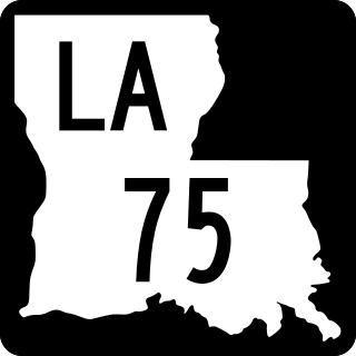
Louisiana Highway 75 (LA 75) is a state highway located in southeastern Louisiana. It runs 46.86 miles (75.41 km) in a general east–west direction from a dead end in Bayou Pigeon to the junction of LA 22 and LA 942 in Darrow.


