
Raleigh is the capital of the state of North Carolina and the seat of Wake County in the United States. Raleigh is known as the "City of Oaks" for its many oak trees, which line the streets in the heart of the city. The city covers a land area of 147.6 square miles (382 km2). The U.S. Census Bureau estimated the city's population as 474,069 as of July 1, 2019. It is one of the fastest-growing cities in the country. The city of Raleigh is named after Walter Raleigh, who established the lost Roanoke Colony in present-day Dare County.
Siler City is a town in western Chatham County, North Carolina, United States. As of the 2010 census, the town's population was 7,887. The population of the small town has increased by 75% from 1990 to 2018. The population was estimated to be 8,205 in 2018.

The North Carolina State Capitol is the former seat of the legislature of the U.S. state of North Carolina which housed all of the state's government until 1888. The Supreme Court and State Library moved into a separate building in 1888, and the General Assembly moved into the State Legislative Building in 1963. Today, the governor and their immediate staff occupy offices on the first floor of the Capitol.

Fayetteville Street is a major street in downtown Raleigh, North Carolina, United States of America. It is a north-south thoroughfare that connects the State Capitol to the Raleigh Convention Center and the Progress Energy Center for the Performing Arts. It is the City of Raleigh's ceremonial center, hosting parades, special events, and seasonal celebrations.

The Joel Lane House, also known as Wakefield, was built in 1769 and is now a restored historic home and museum in Raleigh, North Carolina. It is the oldest dwelling in Wake County and contains collections of 18th century artifacts and period furnishings. The museum grounds include a detached middle class home built circa 1790, a formal city garden, and a period herb garden. The house is named after Joel Lane, the "Father of Raleigh" and "Father of Wake County."

The Pope House Museum, built in 1901, is a restored home once owned by Dr. M. T. Pope, a prominent African-American citizen of Raleigh, North Carolina. The Pope House is listed on the National Register of Historic Places in 1999, It was an official project of the Save America’s Treasures Program and the city of Raleigh took over management of it, offering tours for the first time.
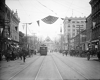
The Fayetteville Street Historic District in Raleigh, North Carolina is a historic district listed on the National Register of Historic Places (NRHP). The District includes the 100-400 blocks of Fayetteville Street, the 00-100 blocks of the south side of West Hargett Street, the 00 block of the north side of West Martin Street, and the 100-400 blocks of South Salisbury Street.
The Moore Square Historic District is a registered historic district located in downtown Raleigh, North Carolina. Listed on the National Register of Historic Places in 1983, the district is centered on Moore Square, one of two surviving four-acre parks from Raleigh's original 1792 plan. The park is named after Alfred Moore, a North Carolina judge who became an Associate Justice on the Supreme Court. Originally a residential neighborhood, Moore Square developed into a primary commercial hub in the city throughout the late 19th and early 20th centuries. The district includes East Hargett Street, once known as Raleigh's "Black Main Street", because it once contained the largest number of businesses owned by African-Americans in the city. City Market, Marbles Kids Museum/IMAX theatre, Pope House Museum, Artspace, and the Long View Center are located in the Moore Square district. Events that take place in Moore Square include the Raleigh Arts Festival, Artsplosure, Movies in the Park, the Street Painting Festival, and the Moore Square Farmer's Market The approximate district boundaries include Person, Morgan, Wilmington, and Davie Streets.

The West Raleigh Historic District in Raleigh, North Carolina is a national historic district listed on the National Register of Historic Places in 2003. Located 1.5 miles (2.41 km) west-northwest of the State Capitol, the district encompasses approximately 332 acres (134 ha). Neighborhoods in the district include: Bedford Heights, Bagwell, Blue Moon Ridge, College Crest, Fairmont, Forest Hills, Harris-Chamberlain, and Wilmont. Most homes in these neighborhoods are one-story and were constructed between the 1930s to 1950s. While the district is mostly residential, churches and commercial buildings are common along Hillsborough Street.
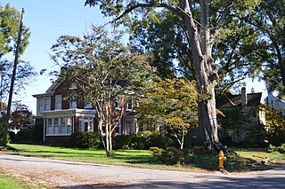
The Bloomsbury Historic District is a neighborhood and national historic district located near downtown Raleigh, North Carolina. Located north of the Five Points intersection, the boundaries include Fairview Road, St. Mary's Street, Byrd Street, Sunset Drive, and Whitaker Mill Road. The residential district encompasses 439 contributing buildings and was developed between about 1914 and 1950. It includes notable examples of Tudor Revival and Bungalow / American Craftsman style architecture.

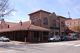
The Depot Historic District is an industrial and commercial neighborhood in downtown Raleigh, North Carolina that was the city's railroad and warehouse distribution hub from the 1850s to 1950s. Located two blocks west of Fayetteville Street and to the north and east of the Norfolk and Southern railroad tracks, the district contains four blocks of 35 brick buildings that date from the 1880s to early 1950s. The district encompasses the southwestern portion of Raleigh's original 1792 town plan and was listed on the National Register of Historic Places in 2002.

The Lumsden–Boone Building is a historic commercial building located at 226 Fayetteville Street in the Fayetteville Street Historic District of Raleigh, North Carolina, United States. Constructed in 1896 for tin and hardware dealer J.C.S. Lumsden, the building is the only surviving metal-front building today on Fayetteville Street. Boone's official business name was "C.R. Boone, DeLuxe Clothier"; his was considered one of the city's leading businesses and boasted the slogan "Come and See". The Lumsden–Boone Building is currently used by a web design company. The building was added to the National Register of Historic Places on September 8, 1983, and was renovated in 1985 and in 2008.

Saint Mary's School is a private independent Episcopal college-preparatory, boarding and day school for girls in grades 9–12. Located in Raleigh, North Carolina, Saint Mary's School operates as an independent school with a historic association with the Episcopal Church including an Episcopal chapel, St. Mary's Chapel, on the school's grounds. The school formerly operated as Saint Mary's College and for many decades educated young women in grades 11–12 and their freshman and sophomore years in college. The school changed to a four year high school in 1998, at which point the name reverted to Saint Mary's School, the original name of the institution when it was founded in 1842.
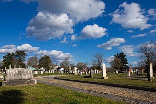
The City Cemetery of Raleigh, also known as Old City Cemetery, was authorized in 1798 by the North Carolina General Assembly as Raleigh's first burying ground. It was laid out on 4 acres (1.6 ha) of land just outside the original 1792 eastern boundary of Raleigh and bounded by East Street on the west, East Hargett Street on the south, and Morgan Street on the north. It was originally laid out in four equal quarters with the northern two quarters reserved for residents, the southwestern for visitors, and the southeastern for Negroes, both free and slaves. Over time, the cemetery has gradually been enlarged toward New Bern Street in 1819, 1849, and 1856 and now contains approximately 7.5 acres (3.0 ha). The cemetery was enclosed in 1898 by a cast-iron fence that was formerly around Union Square to keep straying livestock out of the State Capitol grounds. A network of cobblestone driveways with granite curbstones run through the cemetery. In 1857, the city boundaries were extended to include the cemetery, and the city charter provided for a resident caretaker. Many persons of Raleigh's and North Carolina's early period are interred at City Cemetery including governors, mayors, politicians, newspaper editors, military officers, ministers, doctors, planters, attorneys, bankers, and Scottish and English stonemasons who helped build the Capitol.

The Battery Heights Historic District is a historic neighborhood and national historic district located southeast of downtown Raleigh, North Carolina, USA. Named for the earthen batteries stationed in the area during the Civil War, the neighborhood has a suburban character, despite its close proximity to the city center.

The Jesse R. Siler House is a historic house at 115 West Main Street in Franklin, North Carolina. It is prominently sited at the base of the hill on which most of the city is located. A two-story log structure was built on this site c. 1819, and expanded between 1820 and 1830 by Jesse Siler, a prominent early settler of the area. It was modified significantly over the 19th century, most notably receiving a prominent Greek Revival tetrastyle portico. It retains many interior features from Siler's period of modification, exhibiting transitional Georgian-Federal styling in its mantels.

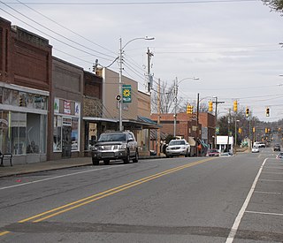
Siler City Commercial Historic District is a national historic district located at Siler City, Chatham County, North Carolina. The district encompasses 45 contributing buildings in the central business district of Siler City. They are primarily one- and two-story brick buildings dated between 1897 and 1945. Located in the district is the separately listed Hotel Hadley. Other notable buildings include the Farmers Alliance Store (1909), Edwards-Wren Building (1906), Chatham Bank (1913), Wren Building (1912), former Siler City Furniture Building (1928), Colonial Revival style United States Post Office (1940), Phillips Office Supplies Building, Thorpe and Associates Building, and Fred C. Justice Building.

North Third Avenue Historic District is a national historic district located at Siler City, Chatham County, North Carolina. The district encompasses seven contributing buildings in a predominantly residential section of Siler City. They were built between about 1890 and 1930, and includes five primary residential dwellings and the First Baptist Church and parsonage. They are representative examples of the Classical Revival and Bungalow / American Craftsman architectural styles.

Longview Gardens Historic District is a historic post-World War II neighborhood and national historic district located 1 1/2-miles east of downtown Raleigh, North Carolina. The district encompasses 189 contributing buildings and five contributing sites. Notable contributing resources include the Raleigh Country Club golf course designed by Donald Ross, Longview Baptist Church and Milner Memorial Presbyterian Church (1946), both striking examples of Modernist architecture.


