East Shelburn, Indiana

Last updated
East Shelburn, Indiana
Unincorporated community
Map of Indiana highlighting Sullivan County.svg
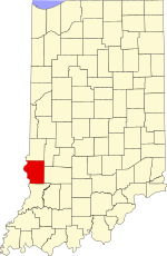
Sullivan County's location in Indiana
Map of Sullivan County Indiana Townships.svg
Red pog.svg
East Shelburn
Coordinates: 39°10′28″N87°22′47″W / 39.17444°N 87.37972°W / 39.17444; -87.37972 Coordinates: 39°10′28″N87°22′47″W / 39.17444°N 87.37972°W / 39.17444; -87.37972
Country United States
State Indiana
County Sullivan
Township Curry
Elevation [1] 525 ft (160 m)
Time zone Eastern (EST) (UTC-5)
  Summer (DST) EDT (UTC-4)
ZIP code 47879
Area code(s) 812, 930
GNIS feature ID 433928

East Shelburn is an unincorporated community in southern Curry Township, Sullivan County, in the U.S. state of Indiana. [2]

Unincorporated area Region of land not governed by own local government

In law, an unincorporated area is a region of land that is not governed by a local municipal corporation; similarly an unincorporated community is a settlement that is not governed by its own local municipal corporation, but rather is administered as part of larger administrative divisions, such as a township, parish, borough, county, city, canton, state, province or country. Occasionally, municipalities dissolve or disincorporate, which may happen if they become fiscally insolvent, and services become the responsibility of a higher administration. Widespread unincorporated communities and areas are a distinguishing feature of the United States and Canada. In most other countries of the world, there are either no unincorporated areas at all, or these are very rare; typically remote, outlying, sparsely populated or uninhabited areas.

Curry Township, Sullivan County, Indiana Township in Indiana, United States

Curry Township is one of nine townships in Sullivan County, Indiana, United States. As of the 2010 census, its population was 3,559 and it contained 1,643 housing units.

Sullivan County, Indiana County in the United States

Sullivan County is a county in the U.S. state of Indiana, and determined by the U.S. Census Bureau to include the mean center of U.S. population in 1940. As of 2010, the population was 21,475. The county seat is Sullivan.

The community is part of the Terre Haute Metropolitan Statistical Area.

Terre Haute, Indiana City in Indiana, United States

Terre Haute is a city in and the county seat of Vigo County, Indiana, United States, near the state's western border with Illinois. As of the 2010 census, the city had a total population of 60,785 and its metropolitan area had a population of 170,943.

Terre Haute metropolitan area human settlement in United States of America

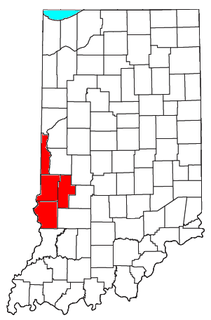
The Terre Haute Metropolitan Statistical Area, also known as the Wabash Valley, is the 227th largest Metropolitan Statistical Area (MSA) in the United States. centering on the city of Terre Haute, it was originally formed by the United States Census Bureau in 1950 and consisted of Vigo County. As surrounding counties saw an increase in their population densities and the number of their residents employed within Vigo County, they met Census criteria to be added to the MSA. Four Indiana counties are now a part of this MSA.

Geography

East Shelburn is located at 39°10′28″N87°22′47″W / 39.17444°N 87.37972°W / 39.17444; -87.37972 .

Related Research Articles

Shelburn, Indiana Town in Indiana, United States

Shelburn is a town in Curry Township, Sullivan County, in the U.S. state of Indiana. The population was 1,252 at the 2010 census. It is part of the Terre Haute Metropolitan Statistical Area.

Nyesville, Indiana Unincorporated community in Indiana, United States

Nyesville, also known as Nowlington, is an unincorporated community in Washington Township, Parke County, in the U.S. state of Indiana.

Whitaker, Indiana Unincorporated community in Indiana, United States

Whitaker is an unincorporated community in Ray Township, Morgan County, in the U.S. state of Indiana.

East Glenn, Indiana Unincorporated community in Indiana, United States

East Glenn is an unincorporated community in central Lost Creek Township, Vigo County, in the U.S. state of Indiana.

Hickory Island, Indiana Unincorporated community in Indiana, United States

Hickory Island is an unincorporated community in Vigo and Clay counties, in the U.S. state of Indiana.

State Line, Vigo County, Indiana Unincorporated community in Indiana, United States

State Line is an unincorporated community in western Sugar Creek Township, Vigo County, in the U.S. state of Indiana.

Hudnut, Indiana Unincorporated community in Indiana, United States

Hudnut, also known as Clinton Locks, is an unincorporated community in western Florida Township, Parke County, in the U.S. state of Indiana, just east of Clinton.

West Melcher, Indiana Unincorporated community in Indiana, United States

West Melcher is an unincorporated community in Reserve Township, Parke County, in the U.S. state of Indiana, located east of Montezuma.

Lettsville is an unincorporated community in Daviess County, Indiana, in the United States.

Antioch, Greene County, Indiana Unincorporated community in Indiana, United States

Antioch is an unincorporated community in the southwestern part of Wright Township, Greene County, Indiana, United States. It lies near the intersection of County Road 575 North and County Road 500 North, which is a community nearly twenty miles west of the city of Bloomfield, the county seat of Greene County. Its elevation is 531 feet, and it is located at 39°05′55″N87°14′15″W.

Denmark, Indiana Unincorporated Community in Indiana, United States

Denmark is an unincorporated community in the southwest portion of Marion Township, Owen County, in the U.S. state of Indiana. It lies near the intersection of County Road 1400 West and County Road 150 South, which is a community about fifteen miles west of the city of Spencer, the county seat of Owen County. Its elevation is 722 feet, and it is located at 39°16′11″N87°1′33″W.

Hubbell, Indiana Unincorporated Community in Indiana, United States

Hubbell is an unincorporated community in the southwestern corner of Jefferson Township, Owen County, in the U.S. state of Indiana. It lies near the intersection of County Road 750 South and Indiana Highway 157, which is a community nearly twenty miles southwest of the city of Spencer, the county seat. Its elevation is 528 feet, and it is located at 39°10′59″N87°0′44″W. This community is also known as Hubbells Station.

Smithville, Owen County, Indiana Unincorporated Community in Indiana, United States

Smithville is an unincorporated community in the northwest corner of Marion Township, Owen County, in the U.S. state of Indiana. It lies near the intersection of County Road 200 North and County Road 1400 West, which is a community about fifteen miles west of the city of Spencer, the county seat. Its elevation is 591 feet, and it is located at 39°19′15″N87°1′33″W.

Hickory Corner, Indiana Unincorporated Community in Indiana, United States

Hickory Corner is an unincorporated community in the northwest corner of Marion Township, Owen County, in the U.S. state of Indiana. It lies near the intersection of County Road 1500 West and Orman Road, which is a community about twenty miles west of the city of Spencer, the county seat. Its elevation is 643 feet, and it is located at 39°18′18″N87°2′40″W.

West New Goshen, Indiana Unincorporated community in Indiana, United States

West New Goshen is an unincorporated community in Fayette Township, Vigo County, in the U.S. state of Indiana.

Keytsville, Indiana Unincorporated community in Indiana, United States

Keytsville is an unincorporated community in Parke and Putnam counties, in the U.S. state of Indiana.

Hirt Corner, Indiana Unincorporated community in Indiana, United States

Hirt Corner is an unincorporated community in Clay and Putnam counties, in the U.S. state of Indiana.

Superior, Indiana Unincorporated community in Indiana, United States

Superior is an unincorporated community in Raccoon Township, Parke County, in the U.S. state of Indiana.

Cincinnati, Parke County, Indiana Unincorporated community in Indiana, United States

Cincinnati is an unincorporated community in Washington Township, Parke County, in the U.S. state of Indiana.

References

  1. "US Board on Geographic Names". United States Geological Survey. October 25, 2007. Retrieved 2016-08-30.
  2. "East Shelburn, Indiana". Geographic Names Information System . United States Geological Survey . Retrieved August 5, 2017.