Merom, Indiana

Last updated
Merom, Indiana
Union Christian College building in Merom.jpg
Sullivan County Indiana Incorporated and Unincorporated areas Merom Highlighted 1848474.svg
Location of Merom in Sullivan County, Indiana.
Coordinates: 39°3′25″N87°34′0″W / 39.05694°N 87.56667°W / 39.05694; -87.56667
Country United States
State Indiana
County Sullivan
Township Gill
Area
[1]
  Total0.35 sq mi (0.92 km2)
  Land0.35 sq mi (0.92 km2)
  Water0.00 sq mi (0.00 km2)
Elevation
[2]
548 ft (167 m)
Population
 (2020)
  Total208
  Density585.92/sq mi (225.91/km2)
Time zone UTC-5 (Eastern (EST))
  Summer (DST) UTC-4 (EDT)
ZIP code
47861
Area code 812
FIPS code 18-48474 [3]
GNIS feature ID 439023
Website http://meromindiana.org/

Merom is a town in Gill Township, Sullivan County, Indiana, United States. The population was 228 at the 2010 census. It is part of the Terre Haute Metropolitan Statistical Area. Nearby is Hallador Energy's Merom Generating Station. [4]

Contents

History

Merom was founded in 1817, and a log courthouse located there served as the first Sullivan County seat. [5]

The town's name commemorates the Battle of the Waters of Merom in the Hebrew Bible. [6] The Merom post office has been in operation since 1818. [7]

Union Christian College existed in Merom from 1859-1924.

Photo from Small Town Indiana photo survey. Merom, Indiana.jpg
Photo from Small Town Indiana photo survey.

Geography

Merom is located at 39°3′25″N87°34′0″W / 39.05694°N 87.56667°W / 39.05694; -87.56667 (39.056950, -87.566573). [8]

According to the 2010 census, the town has a total area of 0.36 square miles (0.93 km2), all land. [9]

The Bluff Park in Merom is the site of the type locality of the Merom Sandstone. [10]

Demographics

Historical population
CensusPop.Note
1860 234
1870 42682.1%
1880 407−4.5%
1890 4121.2%
1900 47816.0%
1910 5219.0%
1920 503−3.5%
1930 397−21.1%
1940 49925.7%
1950 374−25.1%
1960 352−5.9%
1970 305−13.4%
1980 36018.0%
1990 257−28.6%
2000 29414.4%
2010 228−22.4%
2020 208−8.8%
U.S. Decennial Census [11]

2010 census

As of the census [12] of 2010, there were 228 people, 99 households, and 59 families living in the town. The population density was 633.3 inhabitants per square mile (244.5/km2). There were 123 housing units at an average density of 341.7 per square mile (131.9/km2). The racial makeup of the town was 100.0% White. Hispanic or Latino of any race were 0.4% of the population.

There were 99 households, of which 36.4% had children under the age of 18 living with them, 42.4% were married couples living together, 13.1% had a female householder with no husband present, 4.0% had a male householder with no wife present, and 40.4% were non-families. 37.4% of all households were made up of individuals, and 20.2% had someone living alone who was 65 years of age or older. The average household size was 2.30 and the average family size was 2.97.

The median age in the town was 39.4 years. 30.3% of residents were under the age of 18; 4.8% were between the ages of 18 and 24; 21.5% were from 25 to 44; 27.1% were from 45 to 64; and 16.2% were 65 years of age or older. The gender makeup of the town was 50.4% male and 49.6% female.

2000 census

As of the census [3] of 2000, there were 294 people, 108 households, and 81 families living in the town. The population density was 813.7 inhabitants per square mile (314.2/km2). There were 135 housing units at an average density of 373.6 per square mile (144.2/km2). The racial makeup of the town was 98.30% White, 0.68% African American, and 1.02% from two or more races. Hispanic or Latino of any race were 0.68% of the population.

There were 108 households, out of which 43.5% had children under the age of 18 living with them, 60.2% were married couples living together, 9.3% had a female householder with no husband present, and 25.0% were non-families. 21.3% of all households were made up of individuals, and 11.1% had someone living alone who was 65 years of age or older. The average household size was 2.72 and the average family size was 3.12.

In the town, the population was spread out, with 32.0% under the age of 18, 3.4% from 18 to 24, 32.0% from 25 to 44, 19.0% from 45 to 64, and 13.6% who were 65 years of age or older. The median age was 36 years. For every 100 females, there were 101.4 males. For every 100 females age 18 and over, there were 86.9 males.

The median income for a household in the town was $31,528, and the median income for a family was $33,333. Males had a median income of $30,250 versus $20,750 for females. The per capita income for the town was $13,087. About 13.5% of families and 14.5% of the population were below the poverty line, including 11.4% of those under the age of eighteen and 3.6% of those 65 or over.

Education

Merom has a public library, a branch of the Sullivan County Public Library. [13]

The grand opening of the Merom – Gill Township Carnegie Library was on Sep. 1, 1918. The two-story structure has beautiful oak woodwork and paintings by local artist Will Turman. The Merom Library became a part of the Sullivan County Public Library system on Dec. 28, 1967. Locals believe that Merom is the smallest town in the U.S. with a Carnegie-built library.

Arts and culture

The Merom Camp and Retreat Center is located on the site of the former Union Christian College. [14] The Merom Bluff Park, which overlooks the Wabash River and the farm fields of Illinois, is home to the annual Merom Chautauqua. [15]

Related Research Articles

<span class="mw-page-title-main">La Riviera, California</span> Census-designated place in California, United States

La Riviera is a census-designated place (CDP) in Sacramento County, California, United States. It is part of the Sacramento–Arden-Arcade–Roseville Metropolitan Statistical Area. The population was 10,802 at the 2010 census, up from 10,273 at the 2000 census. La Riviera is a primarily residential neighborhood located between the American River on the North side and Highway 50 on the southern border.

<span class="mw-page-title-main">Carthage, Indiana</span> Town in Indiana, United States

Carthage is a town in Ripley Township, Rush County, Indiana, United States, located along the Big Blue River. The population was 927 at the 2010 census.

<span class="mw-page-title-main">Carlisle, Indiana</span> Town in Indiana, United States

Carlisle is a town in Haddon Township, Sullivan County, in the U.S. state of Indiana. The population was 692 at the 2010 census. It is part of the Terre Haute Metropolitan Statistical Area. Carlisle is home to the Wabash Valley Correctional Facility.

<span class="mw-page-title-main">Dugger, Indiana</span> Town in Indiana, United States

Dugger is a town in Cass Township, Sullivan County, Indiana, United States. The population was 920 at the 2010 census. It is part of the Terre Haute Metropolitan Statistical Area.

<span class="mw-page-title-main">Farmersburg, Indiana</span> Town in Indiana, United States

Farmersburg is a town in Curry Township, Sullivan County, Indiana, United States. The population was 1,118 at the 2010 census. It is part of the Terre Haute Metropolitan Statistical Area. The town is adjacent to the Vigo County line and is overshadowed by several large TV and radio transmitter towers.

<span class="mw-page-title-main">Shelburn, Indiana</span> Town in Indiana, United States

Shelburn is a town in Curry Township, Sullivan County, in the U.S. state of Indiana. The population was 1,252 at the 2010 census. It is part of the Terre Haute Metropolitan Statistical Area.

<span class="mw-page-title-main">Sullivan, Indiana</span> City in Indiana, United States

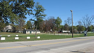
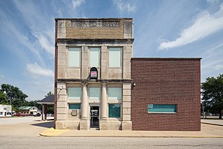
Sullivan is a city in Hamilton Township, Sullivan County, Indiana, United States. The population was 4,249 at the 2010 census. It is part of the Terre Haute Metropolitan Statistical Area. The city is the county seat of Sullivan County.

<span class="mw-page-title-main">Waucoma, Iowa</span> City in Iowa, United States

Waucoma is a city in Fayette County, Iowa, United States. The population was 229 at the time of the 2020 census.

<span class="mw-page-title-main">Springville, Iowa</span> City in Iowa, United States

Springville is a city in Linn County, Iowa, United States. The population was 1,154 at the time of the 2020 census. It is part of the Cedar Rapids Metropolitan Statistical Area.

<span class="mw-page-title-main">Galestown, Maryland</span> Town in Maryland, United States

Galestown is a town in Dorchester County, Maryland, United States. The population was 138 at the 2010 census.

<span class="mw-page-title-main">Seconsett Island, Massachusetts</span> Census-designated place in Massachusetts, United States

Seconsett Island is a census-designated place (CDP) in the town of Mashpee in Barnstable County, Massachusetts, United States. The population was 100 at the 2010 census.

<span class="mw-page-title-main">Hampton, Pennsylvania</span> Census-designated place in Pennsylvania, United States

Hampton is an unincorporated community and census-designated place in Reading Township, Adams County, Pennsylvania, United States. The population was 1,432 at the 2020 census.

<span class="mw-page-title-main">Wiconisco Township, Pennsylvania</span> Township in Pennsylvania, United States

Wiconisco Township is a township in Dauphin County, Pennsylvania, United States. The population was 1,162 in the 2020 census. Wiconisco Township took its name from Wiconisco Creek, a west-flowing tributary of the Susquehanna River.

<span class="mw-page-title-main">Brush Valley Township, Indiana County, Pennsylvania</span> Township in Pennsylvania, United States

Brush Valley Township is a township in Indiana County, Pennsylvania, United States. Brush Valley Township was formed from Wheatfield Township in 1835, and named for the valley of Brush Creek. The population was 1,695 at the 2020 census. It includes the communities of Brush Valley, Claghorn, Dias, Heshbon, Littletown, Rico, and Suncliff.

<span class="mw-page-title-main">Sullivan Township, Pennsylvania</span> Township in Pennsylvania, United States

Sullivan Township is a township in Tioga County, Pennsylvania, United States. The population was 1,470 at the 2020 census.

<span class="mw-page-title-main">Plum Township, Pennsylvania</span> Township in Pennsylvania, United States

Plum Township is a township in Venango County, Pennsylvania, United States. The population was 910 at the 2020 census, a decrease from 1,056 in 2010, which was, in turn a decline from the figure of 1,060 as of the 2000 census.

<span class="mw-page-title-main">Camden-on-Gauley, West Virginia</span> Town in West Virginia, United States

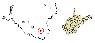
Camden-on-Gauley is a town in Webster County, West Virginia, United States, along the Gauley River. The population was 126 at the 2020 census.

<span class="mw-page-title-main">Smithfield, West Virginia</span> Town in West Virginia, United States

Smithfield is a town in Wetzel County, West Virginia, United States. The population was 103 at the 2020 census.

<span class="mw-page-title-main">Superior, Wyoming</span> Town in Wyoming, United States

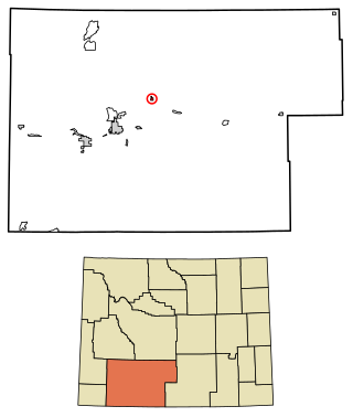
Superior is a town in Sweetwater County, Wyoming, United States. The population was 336 at the 2010 census.

Bingham is a census-designated place (CDP) in the town of Bingham in Somerset County, Maine, United States. The population was 856 at the 2000 census.

References

  1. "2020 U.S. Gazetteer Files". United States Census Bureau. Retrieved March 16, 2022.
  2. "US Board on Geographic Names". United States Geological Survey. 2007-10-25. Retrieved 2008-01-31.
  3. 1 2 "U.S. Census website". United States Census Bureau . Retrieved 2008-01-31.
  4. "Hoosier Energy, Hallador Energy Company finalize ownership transfer of Merom Generating Station, multiyear PPA". www.hoosierenergy.com. Retrieved 24 October 2022.
  5. "Merom Founded 1817". Indiana Historical Bureau. State of Indiana. Retrieved 25 October 2023.
  6. Gannett, Henry (1905). The Origin of Certain Place Names in the United States. U.S. Government Printing Office. p.  206.
  7. "Sullivan County". Jim Forte Postal History. Retrieved August 29, 2016.
  8. "US Gazetteer files: 2010, 2000, and 1990". United States Census Bureau. 2011-02-12. Retrieved 2011-04-23.
  9. "Places: Indiana". 2010 Census Gazetteer Files . United States Census Bureau . Retrieved 2012-04-21.{{cite web}}: External link in |work= (help)
  10. Willman, H. B.; et al. (1975). Handbook of Illinois Stratigraphy. Illinois State Geological Survey Bulletin. Vol. 95. Illinois State Geological Survey. p. 261. hdl:2142/35115.
  11. "Census of Population and Housing". Census.gov. Retrieved June 4, 2015.
  12. "U.S. Census website". United States Census Bureau . Retrieved 2012-12-11.
  13. "Locations". Sullivan County Public Library. Retrieved 15 March 2018.
  14. "Merom Camp & Retreat Center". Merom Camp & Retreat. Merom Camp and Retreat Center. Retrieved 25 October 2023.
  15. "Merom Bluff Park". Discover Sullivan. Sullivan County Tourism Commission. Retrieved 25 October 2023.

Commons-logo.svg Media related to Merom, Indiana at Wikimedia Commons