
Flint is the largest city and seat of Genesee County, Michigan, United States. Located along the Flint River, 66 miles (106 km) northwest of Detroit, it is a principal city within the region known as Mid Michigan. At the 2020 census, Flint had a population of 81,252, making it the twelfth largest city in Michigan. The Flint metropolitan area is located entirely within Genesee County. It is the fourth largest metropolitan area in Michigan with a population of 406,892 in 2020. The city was incorporated in 1855.

Genesee County is a county in the U.S. state of Michigan. As of the 2020 Census, the population was 406,211, making it the fifth-most populous county in Michigan. The county seat and population center is Flint. Genesee County consists of 33 cities, townships, and villages. It is considered to be a part of the greater Mid Michigan area.

Manhattan's Chinatown is a neighborhood in Lower Manhattan, New York City, bordering the Lower East Side to its east, Little Italy to its north, Civic Center to its south, and Tribeca to its west. With an estimated population of 90,000 to 100,000 people, Chinatown is home to the highest concentration of Chinese people in the Western Hemisphere. Manhattan's Chinatown is also one of the oldest Chinese ethnic enclaves. The Manhattan Chinatown is one of nine Chinatown neighborhoods in New York City, as well as one of twelve in the New York metropolitan area, which contains the largest ethnic Chinese population outside of Asia, comprising an estimated 893,697 uniracial individuals as of 2017.
Woodlawn, on the South Side of Chicago, Illinois, is one of Chicago's 77 community areas. It is bounded by Lake Michigan to the east, 60th Street to the north, Martin Luther King Drive to the west, and 67th Street to the south. Both Hyde Park Career Academy and the all-boys Catholic Mount Carmel High School are in this neighborhood; much of its eastern portion is occupied by Jackson Park. The Woodlawn section of the park includes the site of the planned Obama Presidential Center, an estimated $500 million investment. The northern edge of Woodlawn contains a portion of the campus of the University of Chicago.

M-21 is an east–west state trunkline highway in the US state of Michigan connecting the cities of Grand Rapids and Flint. The highway passes through rural farming country and several small towns along its course through the Lower Peninsula. Following the course of a handful of rivers, M-21 also connects some of the state's freeways like Interstate 96 (I-96), US Highway 127 (US 127) and I-75. The highway is used by between 1,700 and 36,000 vehicles daily.

Woodlawn Heights, also known as Woodlawn, is a predominantly Irish-American working class neighborhood at the very north end of the borough of the Bronx in New York City. It is bounded by McLean Avenue to the north, the Bronx River to the east, Woodlawn Cemetery to the south, and Van Cortlandt Park to the west. Woodlawn Heights remains one of the few areas in New York City that still has young Irish immigrants still arriving to the area en masse.

Melrose is a mostly residential neighborhood in the southwestern section of the New York City borough of the Bronx. It adjoins the business and one-time theater area known as The Hub. Melrose is rectangular-shaped, being bordered by Saint Anns Avenue on the east, 149th Street on the south, Park Avenue on the west, and 163rd Street to the north. Melrose Avenue and Third Avenue are the primary thoroughfares through Melrose.

Mott Haven is a primarily residential neighborhood in the southwestern section of the New York City borough of the Bronx. It is generally bounded by East 149th Street to the north, the Bruckner Expressway to the east and south, and the Harlem River to the west, although these boundaries are not precise. East 138th Street is the primary east–west thoroughfare through Mott Haven.

Norwood, also known as Bainbridge, is a working-class residential neighborhood in the northwest Bronx, New York City. It is bound by Van Cortlandt Park and Woodlawn Cemetery to the north, the Bronx River to the east, and Mosholu Parkway to the southwest. The area is dominated topographically by what was once Valentine's Hill, the highest point being near the intersection of 210th Street and Bainbridge Avenue, where Gun Hill Road intersects, and around the Montefiore Medical Center, the largest landowner and employer of the neighborhood. Norwood's main commercial arteries are Gun Hill Road, Jerome Avenue, Webster Avenue, and Bainbridge Avenue.

Williamsbridge is a neighborhood geographically located in the north-central portion of the Bronx in New York City. Its boundaries, starting from the north and moving clockwise are East 222nd Street to the north, Boston Road to the east, East Gun Hill Road to the south, and the Bronx River to the west. White Plains Road is the primary thoroughfare through Williamsbridge.

North Center is one of the 77 community areas of Chicago, Illinois, located in the city's North Side. North Center is bordered on the north by Montrose Avenue, on the south by Diversey Parkway, on the west by the Chicago River and on the east by Ravenswood Avenue; it includes the neighborhoods of North Center, Roscoe Village, St. Ben's, and Hamlin Park. The Brown Line of the Chicago 'L' has stops within the community area at Addison, Irving Park, and Montrose.
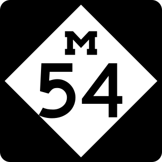
M-54 is a north–south state trunkline highway in the US state of Michigan that bypasses the city of Flint. It is named Dort Highway for much of its length, in honor of Flint carriage and automobile pioneer Josiah Dallas Dort. The portion from the north end of Dort Highway to Clio Road is part of the historic Saginaw Trail, and was also part of the old Dixie Highway. The modern highway runs for 30.276 miles (48.724 km) through Genesee and Saginaw counties from connections with Interstate 75 (I-75) near Grand Blanc on the south to Birch Run on the north. The highway serves mostly suburban and urban sections of the Flint area. Outside of the city, it also passes through agricultural areas in northern Genesee County and southeastern Saginaw County. It also shares a short east–west section with M-83 near Birch Run.
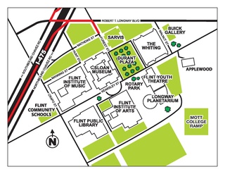
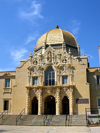
The Flint Cultural Center (FCC) is a campus of cultural, scientific, and artistic institutes located in Flint, Michigan, United States. The institutions located on the grounds of the FCC are the Flint Institute of Arts, Flint Institute of Music, Sloan Museum, Flint Public Library, Buick Gallery & Research Center, Robert T. Longway Planetarium, The Whiting, and the Bower Theatre. The campus and some institutions are owned by Flint Cultural Center Corporation.

Eastside, sometimes known as the State Streets, is a large neighborhood in Flint, Michigan. It is not to be confused with East Flint in which it resides. The neighborhood is bounded on the west by University Park and Buick City, the north by the Northeast Side, the east by Thrift City, and the south by East Village. The neighborhood is anchored on the north and south by two large parks, Whaley and Kearsley, and is also the site of Washington and Williams Elementary Schools, and formerly Homedale Elementary.

Brooklyn is one of the southernmost neighborhoods in Baltimore, Maryland. It is located near Anne Arundel County along Governor Ritchie Highway which is also Maryland Route 2. Its main roads are South Hanover Street,, Potee Street, and East Patapsco Avenue, Sixth Street, Tenth Street, and West Bay Avenue which borders the neighboring Curtis Bay community to the east, running through Bay Brook Park, which separates the two. South Hanover Street also serves as the dividing line between east–west streets in Brooklyn, as Charles Street does not exist here.
The Central Park is a neighborhood in the City of Flint, Michigan. It is bounded as follows: east of Caeser Chavez avenue, south of Kearsley street, west of Crapo street, and north of East Court street.
The West Side is one of the three major sections of the city of Chicago, Illinois, U.S. The other two sections within Chicago that associate with the West Side are the North Side and the South Side. The West Side consists of communities that are of historical, cultural, and ideological importance to the history and development of Chicago. On the flag of Chicago, the West Side is represented by the central white stripe.
This neighborhood is legally known as Woodlawn Park.
