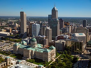
Indianapolis, colloquially known as Indy, is the capital and most populous city of the U.S. state of Indiana and the seat of Marion County. Indianapolis is situated in the state's central till plain region along the west fork of the White River. The city's official slogan, "Crossroads of America", reflects its historic importance as a transportation hub and its relative proximity to other major North American markets.

Fishers is a city in Fall Creek and Delaware townships, Hamilton County, Indiana, United States. As of the 2010 census the population was 76,794, and by 2019 the estimated population was 95,310. A suburb of Indianapolis, Fishers has grown rapidly in recent decades: about 350 people lived there in 1963, 2,000 in 1980, and only 7,500 as recently as 1990.

The University of Indianapolis (UIndy) is a private United Methodist Church-affiliated university in Indianapolis, Indiana. It offers Associate, Bachelor's, Master's, and Doctoral degrees. It was founded in 1902 as Indiana Central University and was popularly known as Indiana Central College from 1921 until 1975. In 1986 the name was changed to University of Indianapolis.

Englewood is a neighborhood and community area located on the South Side of Chicago, Illinois, United States. It is also the 68th of the 77 community areas in the city. At its peak population in 1960, over 97,000 people lived in its approximately 3 square miles (7.8 km2), but the neighborhood's population has since dropped dramatically. In 2000, it had a population of approximately 40,000 inhabitants, and the 2010 census indicated that its population has further declined to approximately 30,000. Englewood to the north, 75th Street to the south, Racine Avenue to the west, and an irregular border that wends along the Metra Railroad Tracks to the east. On the southwest side of Chicago lies West Englewood, which is generally lumped in with Englewood by Chicagoans. Englewood, a low-income African-American community, has a high rate of foreclosed properties due to its population drop.

A dead mall, also known as a ghost mall, zombie mall or abandoned mall, is a shopping mall with low consumer traffic level or is deteriorating in some manner.

Warren Central High School, also known as Warren, WC, or WCHS, is a public high school located in Warren Township on the far east side of Indianapolis, Indiana. It is the only high school in Warren Township with an enrollment of 3,736 students, in grades 9-12, as of the 2016-2017 school year. Warren Central is known as "The Pride of the Eastside". Its school colors are Black and Vegas Gold and the nickname is the Warriors. The school fight song is Rah, Rah For Warren. The original Warren Central opened on January 12, 1925, at the corner of 10th Street and Post Road on the far east side of Indianapolis. It was a consolidation of the Cumberland and Shadeland schools which both had high schools that were too small for the growing township population. Warren Central was built to house grades 7 to 12 and to give the students a city quality education in a farm community. By the late 1950s, the population of Warren Township had once again outgrown its high school and, on September 6, 1960, a new Warren Central opened at its present location off of 9500 East 16th Street. In 1976, the Walker Career Center opened on the property of the high school.

Haughville is a neighborhood west of downtown Indianapolis. Its borders are roughly White River Parkway to the east, Tibbs Avenue to the west, 16th Street to the north, and Michigan Street to the south. It was first settled in the 1830s and grew after a bridge over White River was built connecting to Indianapolis, which annexed the town in 1897. The modern version of the bridge is also the connection between Haughville on the west side of the river and the Sidney & Lois Eskenazi Hospital and Indiana University - Purdue University Indianapolis on the east. The population in the late 1890s included Slovenian, German, and Irish immigrants, among other European immigrants. In the 21st century, the neighborhood suffers from a high crime rate and low property values.

Crispus Attucks High School is a public high school of Indianapolis Public Schools in Indianapolis, Indiana, U.S. Its namesake, Crispus Attucks, was an African American patriot killed during the Boston Massacre. The school was built northwest of downtown Indianapolis near Indiana Avenue and opened on September 12, 1927, when it was the only public high school in the city designated specifically for African Americans.
The William H. Block Company was a department store chain in Indianapolis and other cities in Indiana. It was founded in 1874 by Herman Wilhelm Bloch, an immigrant from Austria-Hungary who had Americanized his name to William H. Block. The main store was located at 9 East Washington Street in Indianapolis in 1896. The company also identified itself as The Wm. H. Block Co., and Block's.
East Memphis is a region of Memphis, Tennessee with several defined and informal subdivisions and neighborhoods such as Colonial Acres, White Station-Yates, Sherwood Forest, Normal Station, High Point Terrace, Belle Meade, Normandy Meadows, St. Nick, Pleasant Acres, Balmoral, and Ridgeway. The general boundaries are informal:
Seven neighborhoods in Indianapolis, Indiana, are designated as official Cultural Districts. These are Broad Ripple Village, Canal and White River State Park, Fountain Square, Indiana Avenue, Market East, Mass Ave, and the Wholesale District.
Downtown Indianapolis is a neighborhood area and the central business district of Indianapolis, Indiana, United States. Downtown is bordered by Interstate 65, Interstate 70, and the White River, and is situated near the geographic center of Marion County. Downtown has grown from the original 1821 town plat—often referred to as the Mile Square—to encompass a broader geographic area of central Indianapolis, containing several smaller historic neighborhoods.

Castleton is a neighborhood area in Lawrence and Washington townships on the northeast side of Indianapolis, Indiana, United States. After shortly over a century of being an independent town, the locality was included in Indianapolis as part of Unigov consolidation in 1970 and was further dissolved in 1992. It is a primarily commercial district today.
The Near East Side is a neighborhood located near downtown Columbus, Ohio, made up of several neighborhoods: Mount Vernon, King-Lincoln Bronzeville, Eastgate, Franklin Park, Nelson Park, Olde Towne East, and Woodland Park.
East Chicago Central High School or commonly known as Central or ECCentral, is a public high school in the industrial City of East Chicago, Indiana, located in the eastern portion of the Chicago metropolitan area.
Eastgate Mall, or Eastgate Shopping Centre, or similar, may refer to:

Indiana is a state in the Midwestern region of the United States. It borders Lake Michigan to the northwest, Michigan to the north and northeast, Ohio to the east, the Ohio River and Kentucky to the south and southeast, and the Wabash River and Illinois to the west. Nicknamed "the Hoosier State", Indiana is the 38th-largest by area and the 17th-most populous of the 50 states. Its capital and largest city is Indianapolis. Indiana was admitted to the United States as the 19th state on December 11, 1816.
Eastgate Consumer Mall, originally Eastgate Shopping Center, was a shopping mall located in Indianapolis, Indiana, United States, at the corner of Washington Street and Shadeland Avenue. It was originally an outdoor mall featuring Sears, JCPenney, and H. P. Wasson and Company; a re-development in 1981 changed it from a conventional shopping center to an outlet mall. After years of decline, the mall closed for business in 2004 and was re-purposed as industrial space.
The economy of Indianapolis is centered on the City of Indianapolis and Marion County within the context of the larger Indianapolis metropolitan area. The Indianapolis–Carmel–Anderson, IN MSA, had a gross domestic product (GDP) of $134 billion in 2015. The top five industries were: finance, insurance, real estate, rental, and leasing ($30.7B), manufacturing ($30.1B), professional and business services ($14.3B), educational services, health care, and social assistance ($10.8B), and wholesale trade ($8.1B). Government, if it had been a private industry, would have ranked fifth, generating $10.2 billion.