McNairy County is a county located in the U.S. state of Tennessee. As of the 2020 census, the population was 25,866. Its county seat and largest city is Selmer. McNairy County is located along Tennessee's border with the state of Mississippi.

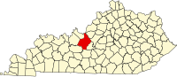
Hardin County is a county located in the central part of the U.S. state of Kentucky. Its county seat is Elizabethtown. The county was formed in 1792. Hardin County is part of the Elizabethtown-Fort Knox, KY Metropolitan Statistical Area, as well as the Louisville/Jefferson County—Elizabethtown-Bardstown, KY-IN Combined Statistical Area. As of the 2020 census, the population was 110,702.

Breckinridge County is a county located in the Commonwealth of Kentucky. As of the 2020 census, the population was 20,432. Its county seat is Hardinsburg, Kentucky. The county was named for John Breckinridge (1760–1806), a Kentucky Attorney General, state legislator, United States Senator, and United States Attorney General. It was the 38th Kentucky county in order of formation. Breckinridge County is now a wet county, following a local-option election on January 29, 2013, but it had been a dry county for the previous 105 years.

Hardin County is a county located in the U.S. state of Illinois. According to the 2020 census, it has a population of 3,649, making it the least populous county in Illinois. Its county seat is Elizabethtown. Hardin County is located in the part of the state known as Little Egypt. Hardin County was named for Hardin County, Kentucky, which was named in honor of Colonel John Hardin, an officer in the American Revolutionary War and the Northwest Indian War.
Hardinsburg is a home rule-class city in Breckinridge County, Kentucky, in the United States. It is the seat of its county. The population was 2,343 at the 2010 census. Hardinsburg was named after Captain William Hardin.
Elizabethtown is a home rule-class city and the county seat of Hardin County, Kentucky, United States. The population was 28,531 at the 2010 census, and was estimated at 31,394 by the U.S. Census Bureau in 2020, making it the 11th-largest city in the state. It is included in the Elizabethtown–Fort Knox, Kentucky Metropolitan Statistical Area, which is included in the Louisville/Jefferson County–Elizabethtown–Madison, Kentucky-Indiana Combined Statistical Area. The Elizabethtown Metropolitan area had a 2019 estimated population of 153,057, making it the 5th-largest metropolitan area in the state.

Radcliff is a home rule-class city in Hardin County, Kentucky, in the United States. The population was 23,042 as of the 2020 Census, up from 21,692 from the 2010 census.

Hardin is a home rule-class city in Marshall County, Kentucky, United States. The population was 580 at the 2020 census.

Martin D. Hardin was a politician and lawyer from Kentucky. Born in Pennsylvania, his family immigrated to Kentucky when he was still young. He studied law under George Nicholas and commenced practice at Richmond, Kentucky. His cousin, future U.S. Representative Benjamin Hardin, studied in his law office. He represented Madison County in the Kentucky House of Representatives for a single term.

Elizabethtown Community and Technical College (ECTC) is a public community college in Elizabethtown, Kentucky. It is part of the Kentucky Community and Technical College System (KCTCS).
John Hardin High School is a school located in Radcliff, Kentucky, but served by the post office of neighboring Elizabethtown. Established in 2001, the school is named after the Revolutionary War officer and Native American fighter, John Hardin.
Cecilia is a census-designated place (CDP) and unincorporated community in Hardin County, Kentucky, United States. It is located 6 miles (10 km) west of Elizabethtown, the county seat. As of the 2020 Census, the population was 575, stagnant from the 2010 census population of 572.

Kentucky is a village in the New England region of New South Wales, Australia. It is about 17 kilometres (11 mi) south of Uralla and 35 kilometres (22 mi) north-west of Walcha and about 7 kilometres (4 mi) off the New England Highway. Kentucky is located 540 kilometres (336 mi) by rail from Sydney in Sandon County on the Northern Tablelands. It is at an altitude of 1066m and is within Uralla Shire. At the 2016 census, Kentucky had a population of 158.
The Elizabethtown–Fort Knox Metropolitan Statistical Area, as defined by the United States Census Bureau, is an area consisting of two counties in Kentucky, anchored by the city of Elizabethtown and the nearby Fort Knox Army post. As of the 2020 census, the MSA had a population of 155,572.

WAAJ is a contemporary Christian–formatted radio station licensed to Benton, Kentucky, United States, and serving the Jackson Purchase area of western Kentucky, including Paducah. The station is owned by Pennyrile Christian Community, Inc. as part of a triopoly with Southern Gospel station WTRT and Christian radio station WVHM. All three stations share studios on College Street in downtown Hardin, Kentucky, while its transmitter facilities are located off Cedar Knob Road in rural Marshall County, Kentucky southeast of Benton and northeast of Hardin.

Rineyville is an unincorporated community and census-designated place (CDP) in Hardin County, Kentucky, United States. It is located 7 miles (11 km) northwest of Elizabethtown. The population was 3,039 as of the 2020 Census. The Paducah and Louisville Railway runs north and south through the community.
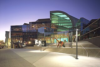
The Kentucky Center for the Performing Arts in Louisville, Kentucky, which opened in 1983, is owned by Kentucky Performing Arts and has tenants that include Kentucky Opera, Louisville Ballet, the Louisville Orchestra, StageOne Family Theatre and Broadway Across America. Sculptural artwork at the site is by Alexander Calder, Joan Miró, John Chamberlain, Jean Dubuffet and others.
Hardin Springs is an unincorporated community in Hardin County, Kentucky, United States. Hardin Springs is located on Kentucky Route 84, 22.4 miles (36.0 km) southwest of Elizabethtown. Hardin Springs is also home to the Hardin Springs School, a building which is on the National Register of Historic Places.

St. Mary is a home rule-class city in Marion County, Kentucky, in the United States. As of the 2020 census, the population of the city was 138.
Millerstown is an unincorporated community in Grayson County, Kentucky, in the United States.