Ecru, Mississippi

Last updated

Ecru, Mississippi
Ecru-water-tower-ms.jpg
Water tower in Ecru
Pontotoc County Mississippi Incorporated and Unincorporated areas Ecru Highlighted.svg
Location of Ecru, Mississippi
Usa edcp location map.svg
Red pog.svg
Ecru, Mississippi
Location in the United States
Coordinates: 34°21′20″N89°1′39″W / 34.35556°N 89.02750°W / 34.35556; -89.02750
Country United States
State Mississippi
County Pontotoc
Area
[1]
  Total4.72 sq mi (12.22 km2)
  Land4.71 sq mi (12.21 km2)
  Water0.01 sq mi (0.01 km2)
Elevation
387 ft (118 m)
Population
 (2020)
  Total901
  Density191.09/sq mi (73.78/km2)
Time zone UTC-6 (Central (CST))
  Summer (DST) UTC-5 (CDT)
ZIP code
38841
Area code 662
FIPS code 28-21340
GNIS feature ID0669661

Ecru is a town in Pontotoc County, Mississippi. The population was 895 at the 2010 census. Ecru is home to the largest upholstered furniture plant in the world which manufactures Ashley Furniture. [2]

Contents

History

Ecru was established by Colonel William Clark Falkner, a prominent post-Civil War businessman. The name of the town comes from the color of its first railroad depot. [3]

Geography

Ecru is located in northern Pontotoc County along Mississippi Highway 15, with the older parts of town stretching eastward along Mississippi Highway 345. The Ashley Furniture plant lies in the southwestern part of town along Mississippi Highway 346. MS 15 connects Ecru to Interstate 22 and New Albany to the north, and Pontotoc to the south. The Little Tallahatchie River, a tributary of the Tallahatchie River, flows through southern Ecru. A rail trail, the Tanglefoot Trail, passes through the town.

According to the United States Census Bureau, the town has a total area of 4.1 square miles (11 km2), of which 4.1 square miles (11 km2) is land and 0.24% is water.

Demographics

Historical population
CensusPop.Note
1910 475
1920 64235.2%
1930 560−12.8%
1940 6017.3%
1950 494−17.8%
1960 442−10.5%
1970 417−5.7%
1980 68764.7%
1990 6961.3%
2000 94736.1%
2010 895−5.5%
2020 9010.7%
U.S. Decennial Census [4]

As of the census [5] of 2000, there were 947 people, 374 households, and 259 families residing in the town. The population density was 231.3 inhabitants per square mile (89.3/km2). There were 411 housing units at an average density of 100.4 per square mile (38.8/km2). The racial makeup of the town was 82.37% White, 14.36% African American, 0.32% Native American, 1.80% from other races, and 1.16% from two or more races. Hispanic or Latino of any race were 2.64% of the population.

There were 374 households, out of which 32.4% had children under the age of 18 living with them, 54.3% were married couples living together, 11.8% had a female householder with no husband present, and 30.5% were non-families. 28.1% of all households were made up of individuals, and 12.3% had someone living alone who was 65 years of age or older. The average household size was 2.46 and the average family size was 3.05.

In the town, the population was spread out, with 24.9% under the age of 18, 8.4% from 18 to 24, 28.1% from 25 to 44, 21.3% from 45 to 64, and 17.2% who were 65 years of age or older. The median age was 37 years. For every 100 females, there were 95.3 males. For every 100 females age 18 and over, there were 91.6 males.

The median income for a household in the town was $30,815, and the median income for a family was $38,571. Males had a median income of $27,961 versus $20,263 for females. The per capita income for the town was $15,447. About 6.5% of families and 11.4% of the population were below the poverty line, including 10.4% of those under age 18 and 21.8% of those age 65 or over.

Education

The town of Ecru is served by the Pontotoc County School District. [6]

Related Research Articles

<span class="mw-page-title-main">Union County, Mississippi</span> County in Mississippi, United States

Union County is a county located in the U.S. state of Mississippi. It was formed in 1870 from Tippah and Pontotoc counties, and in 1874 a portion of Lee County was added. As of the 2020 census, the population was 27,777. Its county seat is New Albany. According to most sources, the county received its name by being a union of pieces of several large counties, like other Union counties in other states. However, other sources say that the name was meant to mark the re-union of Mississippi and the other Confederate states after the Civil War.

<span class="mw-page-title-main">Tippah County, Mississippi</span> County in Mississippi, United States

Tippah County is a county located on the northern border of the U.S. state of Mississippi. As of the 2020 census, the population was 21,815. Its county seat is Ripley. The name "Tippah" is derived from a Chickasaw language word meaning "cut off." It was taken from the creek of the same name that flows across much of the original county from northeast to southwest before emptying into the Tallahatchie River. The creek probably was so named because it, and the ridges on either side, "cut off" the western part of the region from the eastern portion.

<span class="mw-page-title-main">Tallahatchie County, Mississippi</span> County in Mississippi, United States

Tallahatchie County is a county in the U.S. state of Mississippi. At the 2020 census, the population was 12,715. Its county seats are Charleston and Sumner.

<span class="mw-page-title-main">Pontotoc County, Mississippi</span> County in Mississippi, United States

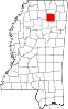
Pontotoc County is a county located in the U.S. state of Mississippi. As of the 2020 census, the population was 31,184. Its county seat is Pontotoc. It was created on February 9, 1836, from lands ceded to the United States under the Chickasaw Cession. Pontotoc is a Chickasaw word meaning "land of hanging grapes". The original Natchez Trace and the current-day Natchez Trace Parkway both pass through the southeast corner of Pontotoc County.

<span class="mw-page-title-main">Panola County, Mississippi</span> County in Mississippi, United States

Panola County is a county located in the U.S. state of Mississippi. As of the 2020 census, the population was 33,208. Its county seats are Sardis and Batesville. The county is located just east of the Mississippi Delta in the northern part of the state. It is bisected by the Tallahatchie River flowing to the southwest; travel difficulties because of the river resulted in two county seats being established.

<span class="mw-page-title-main">Lee County, Mississippi</span> County in Mississippi, United States

Lee County is a county in U.S. state of Mississippi. At the 2020 census, the population was 83,343. Lee County is included in the Tupelo Micropolitan Statistical Area.

<span class="mw-page-title-main">Calhoun County, Mississippi</span> County in Mississippi, United States

Calhoun County is a county located in the U.S. state of Mississippi. As of the 2020 census, the population was 13,266. Its county seat is Pittsboro. The county is named after John C. Calhoun, the U.S. Vice President and U.S. Senator from South Carolina.

<span class="mw-page-title-main">Bruce, Mississippi</span> Town in Mississippi, United States

Bruce is a town situated along the Skuna River in Calhoun County, Mississippi, United States. As of the 2020 census, it had a population of 1,707.

<span class="mw-page-title-main">Derma, Mississippi</span> Town in Mississippi, United States

Derma is a town in Calhoun County, Mississippi, United States. The population was 1,025 at the 2010 census.

<span class="mw-page-title-main">Algoma, Mississippi</span> Town in Mississippi, United States

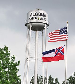
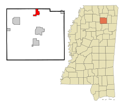
Algoma is a town in Pontotoc County, Mississippi. The population was 705 at the 2020 census, up from 590 at the 2010 census.

<span class="mw-page-title-main">Thaxton, Mississippi</span> Town in Mississippi, United States

Thaxton is a town in Pontotoc County, Mississippi, United States. The population was 643 at the 2010 census.

<span class="mw-page-title-main">Charleston, Mississippi</span> City in Mississippi, United States

Charleston is a city in north central Mississippi and one of the two county seats of Tallahatchie County, which is located on both sides of the Tallahatchie River. This city is located east of the river and its population was 2,193 at the 2010 census.

<span class="mw-page-title-main">Glendora, Mississippi</span> Village in Mississippi, United States

Glendora is a village in Tallahatchie County, Mississippi. The population was 285 at the 2000 census.

<span class="mw-page-title-main">Webb, Mississippi</span> Town in Mississippi, United States

Webb is a town in Tallahatchie County, Mississippi. The population was 565 at the 2010 census.

<span class="mw-page-title-main">Tishomingo, Mississippi</span> Town in Mississippi

Tishomingo is a town in Tishomingo County, Mississippi, United States. The population of the city of Tishomingo was 339 at the 2010 census.

<span class="mw-page-title-main">New Albany, Mississippi</span> City in Mississippi, United States

New Albany is a city in and the county seat of Union County, Mississippi, United States. According to the 2020 United States Census, the population was 7,626.

<span class="mw-page-title-main">Potts Camp, Mississippi</span> Town in Mississippi, United States

Potts Camp is a town in Marshall County, Mississippi, United States. The population was 416 at the 2020 census, down from 523 in 2010.

<span class="mw-page-title-main">Toccopola, Mississippi</span> Town in Mississippi, United States

Toccopola is a town in Pontotoc County, Mississippi, United States. The population was 246 at the 2010 census.

<span class="mw-page-title-main">Sherman, Mississippi</span> Town in Mississippi, United States

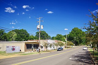
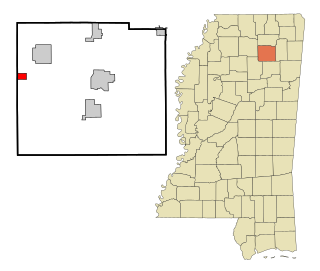
Sherman is a town which straddles Lee, Pontotoc, and Union counties in Mississippi. The population was 600 at the 2020 census.

<span class="mw-page-title-main">Nelson, Wisconsin</span> Village in Wisconsin, United States

Nelson is a village in Buffalo County in the U.S. state of Wisconsin. The population was 374 at the 2010 census. The village is surrounded by the Town of Nelson.

References

  1. "2020 U.S. Gazetteer Files". United States Census Bureau. Retrieved July 24, 2022.
  2. "djournal.com - News, Business, Classifieds, and Events in Northeast Mississippi".
  3. Federal Writers' Project, The WPA Guide to Mississippi: The Magnolia State (Trinity Press, 2013; originally published in 1938).
  4. "Census of Population and Housing". Census.gov. Retrieved June 4, 2015.
  5. "U.S. Census website". United States Census Bureau . Retrieved January 31, 2008.
  6. "2020 CENSUS - SCHOOL DISTRICT REFERENCE MAP: Pontotoc County, MS" (PDF). U.S. Census Bureau. Archived (PDF) from the original on August 1, 2022. Retrieved July 31, 2022. - Text list