Edward Moseley

Last updated

Edward Moseley
Personal details
Born ca. 16 February 1683
St. Giles, Cripplegate, London, England
Died11 July 1749
North Carolina
Spouse(s)Ann Walker
Ann Sampson
Education Christ's Hospital

Edward Moseley (ca. 16 February 1683 - 11 July 1749), was a British colonial official who served as the first public treasurer of North Carolina from 1715 until his death in July 1749). He previously served as the surveyor-general of North Carolina before 1710 and again from 1723 to 1733. Moseley was also responsible, with William Byrd of Virginia, for surveying the boundary between North Carolina and Virginia in 1728.

Contents

Moseley also served as speaker of the North Carolina House of Burgesses (the lower house of the provincial legislature) for several terms, as he was consistently re-elected by his party. He briefly acted as governor while Governor Burrington was out of the province.

Early life and education

Coat of Arms of Edward Moseley Coat of Arms of Edward Mosley.svg
Coat of Arms of Edward Moseley

John Moseley married Mary Beaman at All Hallows London Wall on February 5, 1681/2. Their son Edward was born February 16, 1682/3 just prior to his father's release from indenture. John Moseley began his own merchant tailor business in Cripplegate, just west of Bishopsgate; but he had died by April 1690 when his orphaned son applied to Christ's Hospital. School records confirm that Moseley was a pupil at Christ's Hospital, Newgate, in a division called the Royal Mathematical School which had been founded in 1673 to supply educated navigators to the navy and merchant marine. Moseley applied to the school at the age of 7 or 8 and was accepted the following year on July 2, 1691. There, he studied the trade of a navigator for more than six years.

Discharge records show that Moseley left Christ's Hospital December 24, 1697, aged 14/15, to serve an apprenticeship which was to last until December 1703, with Captain Jacob Foreland on the ship Joseph, trading in the port of Bilbao (a Spanish iron market). Curiously and somewhat irregularly, a handwritten postscript to the indenture with Foreland states "friends of the said boy would not suffer him to be bound to the said captain and have otherwise provided for him." Unknown wealthy friends of Moseley purchased his indenture so that he would not have to go to Spain with Foreland. Soon thereafter, Moseley landed in Charleston, Carolina. [1]

Moseley served southern Carolina as an Ordinary Court clerk (January 1701-02) directly under Governor James Moore. Moseley ceased his role when Nathaniel Johnson succeeded Moore. A possible friend of Moseley's, John Barnhill (later known as “Tuscarora Jack”), replaced him at that time. Afterward, Moseley worked under Dr. Thomas Bray as a librarian for the Society for the Propagation of the Gospel in Foreign Parts in 1703. While in Charleston, Moseley demonstrated a fondness for books and administration and, as a good Anglican, collected religious texts that he later donated to the Anglican Church in Chowan County. Moseley received £5 15s for cataloging the first library in Carolina. This work he performed for Dr. Bray and the Society in May 1703, following the books’ arrival in Charleston.

Through Dr. Bray's acquaintance, he met northern Carolina's, or Albemarle County's, governor Henderson Walker and his wife Ann. Gov. Walker seemed greatly interested in obtaining a similar Christian library for Albemarle’s capital of “Queen Anne’s Town,” later Edenton. In October 1703, Walker wrote to the Bishop of London, Thomas Tenison, requesting a gift similar to the Rev. Bray's. [1]

In April 1704, Governor Walker died. Moseley moved to the Albemarle Sound region and married Mrs. Walker in 1705. Moseley, then about 23 years old, began his career as a surveyor and lawyer.

Career

North Carolina Colonial currency (1729) signed by Moseley. US-Colonial (NC-33)-North Carolina-27 Nov 1729 OBV.jpg
North Carolina Colonial currency (1729) signed by Moseley.

Moseley became a planter, lawyer, surveyor, and politician, with extensive land holdings (at least 55,000 acres) and numerous slaves for the labor of cultivating tobacco, pine trees, rice, and other crops. Known for his generosity to community and church, Moseley may be best remembered for his detailed map of the North Carolina colony, which he published in 1733. [2] A revised version was drawn by the original engraver, John Cowley of London, in 1737. [3] Both were lasting contributions to the settlement of the colony. East Carolina University's Special Collections house perhaps the original copy of the map of 1733, owned by Moseley himself in Greenville, and it held quite a history of its own. [4] An earlier map of the Albemarle (1708) made by Moseley was recently discovered by Dr. Larry Tise of East Carolina University in a publication of treasures from the Lambeth Palace Collection of the Society for the Propagation of the Gospel. [1]

Even though an Anglican, Moseley supported the rights of Dissenters, including Quakers, during Cary's Rebellion, albeit for pecuniary reasons. He also supported the growth of the Anglican Church.

Moseley was a personally motivated, opportunistic man who suffered the vagaries of rival surveyors and colonial justice. He evidently used his authority as surveyor unwisely and was twice accused of not having set foot on the properties that he had supposedly surveyed. Virginia authorities, hungry for a favorable boundary between Virginia and North Carolina, ignored Moseley's more accurate determination of that line, described in the Carolina Charter. By 1711, he was removed as the colony's surveyor and fined £500, having to return all the surveying fees that he had collected near the border. [5]

Later, Moseley was banned from holding public office for several years because he tried to obtain evidence to link Colonial Governor Charles Eden to the pirate Edward Teach known as Blackbeard. Moseley and his brother-in-law Maurice Moore had forcibly entered the office of the colonial secretary in 1718 in search of incriminating evidence and had been surrounded by the governor's agents. Angry words were exchanged. When Moseley's case came to trial the following year, he was accused of uttering "seditious words" against the governor at the time. Despite at least one member of the jury being a former legal client of Moseley, Governor Eden's attorney obtained a conviction.

The conviction was merely a slap on the wrist, for Moseley became surveyor-general again in 1723. He was appointed Treasurer of the Province in 1735, a position he held until his death.

As a member of "the Family," elite South Carolinian planters who tried to usurp the Lower Cape Fear from the king, he legislatively supported Brunswick Town's founder, brother-in-law Maurice Moore, during the royal government's attempt to restore order in 1732–33. Royal authorities created the successful port town of Wilmington from the opposition. Later, Moseley removed to Brunswick Town, where he died in 1749. [1]

Personal life

In August 1705 Moseley married the former Ann Lillington, widow of Governor Henderson Walker and daughter of Major Alexander Lillington, in the eastern Chowan District of North Carolina. Edward became allied with the Lillingtons and other prominent families. He and Ann had two sons. [6]

After Ann's death, Moseley married Ann Sampson and moved from Edenton to Brunswick Town. They had a large family of sons and daughters. [6]

See also

Citations

  1. 1 2 3 4 Brooks, Baylus C. (18 February 2013). "B.C. Brooks: A Writer's Hiding Place: Edward Moseley: Impressions of the Albemarle".
  2. "New and Correct Map of the Province of North Carolina". digital.lib.ecu.edu.
  3. "A New and Correct Map of the Province of North Carolina: The Discovery of a 1737 North Carolina Manuscript Map - The MESDA Journal". www.mesdajournal.org.
  4. Brooks, Baylus C. (14 April 2014). "B.C. Brooks: A Writer's Hiding Place: Edward Moseley's 1733: North Carolina's Tale of Two and a Half Maps".
  5. "Documenting the American South: Colonial and State Records of North Carolina".
  6. 1 2 Edward McCrady, Samuel A'Court Ashe, Cyclopedia of Eminent and Representative Men of the Carolinas of the Nineteenth Century, Brant & Fuller, 1892, pp.469-470, digitized 2007, University of Virginia

Related Research Articles

<span class="mw-page-title-main">Chowan County, North Carolina</span> County in North Carolina, United States

Chowan County is one of the 100 counties located in the U.S. state of North Carolina. As of the 2020 census, the population was 13,708. Its county seat is Edenton. The county was created between 1668 and 1671 as Shaftesbury Precinct and later renamed Chowan Precinct. It gained county status in 1739.

<span class="mw-page-title-main">Edenton, North Carolina</span> Town in North Carolina, United States

Edenton is a town in, and the county seat of, Chowan County, North Carolina, United States, on Albemarle Sound. The population was 4,397 at the 2020 census. Edenton is located in North Carolina's Inner Banks region. In recent years Edenton has become a popular retirement location and a destination for heritage tourism.

<span class="mw-page-title-main">Province of North Carolina</span> Former British province in North America

The Province of North Carolina, originally known as Albemarle Province, was a province of Great Britain that existed in North America from 1712 to 1776.(p. 80) It was one of the five Southern colonies and one of the thirteen American colonies. The monarch of Great Britain was represented by the Governor of North Carolina, until the colonies declared independence on July 4, 1776.

<span class="mw-page-title-main">Province of Carolina</span> English (later British) colony in North America and the Caribbean (1663–1712)

The Province of Carolina was a province of the Kingdom of England (1663–1707) and later the Kingdom of Great Britain (1707–1712) that existed in North America and the Caribbean from 1663 until partitioned into North and South on January 24, 1712. It consisted of all or parts of present-day Alabama, Florida, Georgia, Mississippi, North Carolina, South Carolina, Tennessee, and the Bahamas.

Thomas Walker was a physician, planter and explorer in colonial Virginia who served multiple terms in the Virginia General Assembly, and whose descendants also had political careers. Walker explored Western Colony of Virginia in 1750, 19 years before the arrival of Daniel Boone.

Peter Jefferson was a planter, cartographer and politician in colonial Virginia best known for being the father of the third president of the United States, Thomas Jefferson. The "Fry-Jefferson Map", created by Peter in collaboration with Joshua Fry in 1757, accurately charted the Allegheny Mountains for the first time and showed the route of "The Great Road from the Yadkin River through Virginia to Philadelphia distant 455 Miles"—what would later come to be known as the Great Wagon Road.

William Drummond was a Scottish indentured servant in Virginia who became the first colonial governor of Albemarle Sound settlement in the Province of Carolina, but alienated Virginia governor William Berkeley, became a ringleader of Bacon's Rebellion and was executed after his capture.

<span class="mw-page-title-main">Meherrin</span>

The Meherrin people are an Indigenous people of the Northeastern Woodlands, who spoke an Iroquian language. They lived between the Piedmont and coastal plains at the border of Virginia and North Carolina.

<span class="mw-page-title-main">Lawrence Washington (1718–1752)</span> Virginian soldier, planter, politician, and prominent landowner in colonial Virginia

Lawrence Washington was an American soldier, planter, politician, and prominent landowner in colonial Virginia. As a founding member of the Ohio Company of Virginia, and a member of the colonial legislature representing Fairfax County, he also founded the town of Alexandria, Virginia on the banks of the Potomac River in 1749.

William Churton was an early North Carolina surveyor.

Cary's Rebellion was an uprising against the Deputy Governor of North-Carolina in 1711 led by Thomas Cary, who refused to give up his governorship to Edward Hyde. The rebellion was a part of a long-standing tension between religious and political groups in northern Carolina, generally divided between the Quaker party, of which Cary was a part, and the Church of England party, to which Hyde belonged.

<span class="mw-page-title-main">Nathaniel Batts</span>

Nathaniel Batts (–1679) was a fur trader, explorer and Indian interpreter. He became the first recorded European to permanently settle in North Carolina in 1655. He often appears as Captain Nathaniel Batts in the records of Norfolk County, Virginia, where his wife owned land by her prior husband, Henry Woodhouse.

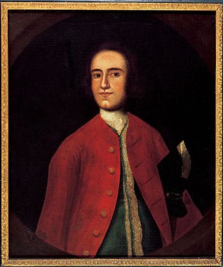
Colonel Joshua Fry (1699–1754) was an English-born American adventurer who became a professor, then real estate investor and local official in the colony of Virginia. Although he served several terms in the House of Burgesses, he may be best known as a surveyor and cartographer who collaborated with Peter Jefferson, the father of future U.S. president Thomas Jefferson. After Fry’s death on a military expedition, George Washington became commanding officer of the Virginia Regiment, a key unit in what became the French and Indian War.

<span class="mw-page-title-main">North Carolina Highway 37</span> State highway in North Carolina, US

North Carolina Highway 37 (NC 37) is a primary state highway in the northeastern part of the U.S. state of North Carolina. Traveling north–south, it serves as a connector route from U.S. Route 64 (US 64) to Hertford and from US 13 to Gatesville.

John Alexander Lillington, also known as Alexander John Lillington, was an American planter, politician and Patriot officer from North Carolina in the American Revolutionary War. He fought in the Battle of Moore's Creek Bridge in 1776 as Colonel of the Wilmington District Minutemen. He was afterwards commissioned as colonel of the 6th North Carolina Regiment of the Continental Army, but resigned after a month to instead serve as brigadier general of the Wilmington District Brigade of the North Carolina militia. At the Battle of Camden his troops were among the militia who fled the field. His son John Lillington also served in the North Carolina militia.

<span class="mw-page-title-main">Seth Sothel</span>

Seth Sothel was a colonial fradulent American proprietor and governor of the Province of Carolina. He claimed he ruled the northern portion, Albemarle Sound, in 1678 and the southern portion from 1690 to 1692. He died in North Carolina in about 1694.

Henderson Walker (1659-1704) was the Acting Deputy Governor of North Carolina from 1699 to 1704. He is better known for his contribution in the founding of the Church of England in the Albemarle Sound region.

Robert Quary (1644–1712) was a governor of the English proprietary Province of Carolina during 1685. He would later serve on the provincial councils of several other colonies.

<span class="mw-page-title-main">1st North Carolina Infantry Regiment</span> Military unit

The 1st North Carolina Infantry Regiment was an infantry regiment of the Confederate States Army during the American Civil War. As part of the Army of Northern Virginia it fought in the Eastern Theater until the surrender at Appomattox.

The North Carolina–Tennessee–Virginia Corners is a tripoint at which North Carolina, Tennessee and Virginia meet. The landmark is located in the Iron Mountains, and is roughly 16 miles north of Snake Mountain, and 8 miles southwest of Mount Rogers.

References