Effects of Hurricane Matthew in Florida

Last updated

Map key
  Tropical depression (≤38 mph, ≤62 km/h)
  Tropical storm (39–73 mph, 63–118 km/h)
  Category 1 (74–95 mph, 119–153 km/h)
  Category 2 (96–110 mph, 154–177 km/h)
  Category 3 (111–129 mph, 178–208 km/h)
  Category 4 (130–156 mph, 209–251 km/h)
  Category 5 (≥157 mph, ≥252 km/h)
  Unknown
Storm type
Disc Plain black.svg Tropical cyclone
Solid black.svg Subtropical cyclone
ArrowUp.svg Extratropical cyclone, remnant low, tropical disturbance, or monsoon depression

Tropical Storm Matthew developed on September 28 from a tropical wave moving through the southern Lesser Antilles. Low wind shear and warm waters favored strengthening, [1] and the storm intensified into a hurricane on September 29. [2] Early on October 1, following a period of rapid deepening, Matthew reached Category 5 on the Saffir-Simpson scale, with peak sustained winds of 270 km/h (170 mph) while offshore of northern Colombia. [2] By October 3, the hurricane was moving northward through the Caribbean Sea around the western periphery of a large ridge, having weakened slightly. [2] On the next day, Matthew re-intensified to attain a minimum central pressure of 934 mbar (27.6 inHg), along with winds of 240 km/h (150 mph) around its well-defined eye. [2] On October 4, with winds of 150 mph (240 km/h), Matthew made landfall in Haiti near Les Anglais. Weakening slightly, Matthew then made landfall near Maisí in Cuba. The storm started to accelerate, passingly through The Bahamas. Matthew then moved parallel to the coast of Florida, coming within just 20 miles (32 km) or so from coming ashore. The storm kept moving north before striking North Carolina, and eventually dissipated offshore on October 10.

Preparations

On September 30, Governor Rick Scott made a statement to residents, urging them to be vigilant of the approaching hurricane. [3] Forecasts the following day indicated that Matthew had the potential to be the most powerful hurricane to threaten the state since Wilma in 2005. The state's Division of Emergency Management urged residents to not be complacent and urged those living along the east coast to prepare accordingly. [4] Governor Scott began regular phone conferences with Rick Knabb—the director of the National Hurricane Center—and officials in all 67 counties on October 2. Although the center of Matthew was forecast to remain offshore, Scott stated: "This storm is catastrophic, and if it hits our state, we could see impacts that we have not seen in many years". [5] All counties were placed under a state of emergency on October 3 in accordance with Executive Order 16-230. This enabled the allocation of federal funds for emergency preparations to ensure the safety of residents. The Florida National Guard was placed on standby and fuel trucks were placed along the Florida Turnpike for quick deployment anywhere in the state. [6] About 200 National Guardsmen were deployed on October 4. [7] On the afternoon of October 4, Everglades National Park and Biscayne National Park were shut down. [8] [9]

Grade schools and universities across the east Coast announced closures for October 6–9. [10] A further 1,200 members of the Florida National Guard were deployed on this day, [11] [12] and another 2,000 on October 6. [10] [13] The state government opened 130 shelters while the American Red Cross opened 97 of their own. [14] [15] The Florida Department of Transportation suspended all construction projects on interstates, limited access facilities, coastal, and evacuation route roadways. Bridges along the Intracoastal Waterway were to be shut down prior to the onset of gale-force winds. [11] All tunnels in the Miami Metropolitan Area were closed and the Tri-Rail suspended service for the duration of Matthew's passage. [10] Service at Fort Lauderdale-Hollywood International Airport, North Perry Airport, and Orlando Sanford International Airport was suspended on October 6, resulting in the cancellation of hundreds of flights. A further 600 flights were cancelled at Miami International Airport; however, the airport remained open. [16] Numerous flights to aforementioned airports were diverted to Tampa International to compensate for closures. [17]

In preparation for heavy rainfall, the United States Army Corps of Engineers maximized water discharges in Lake Okeechobee while the South Florida Water Management District lowered canal levels. [11] More than 50 state parks and campgrounds were closed across the state. [10]

On October 5, Port Canaveral was closed by the U.S. Coast Guard, the first closure since 2004. Eight cruise ships and four cargo ships were scheduled to visit the port between October 5–9. [18] On Cape Canaveral, home to both civilian and military spaceflight facilities, no rockets or spacecraft were in vulnerable positions; at the time of Matthew's approach, the next launch was scheduled for November 4. [19] The Kennedy Space Center began preparations of the facilities on October 5. Older buildings at the KSC were designed to withstand winds of 105–125 mph (170–200 km/h); buildings constructed after 1992, when Category 5 Hurricane Andrew struck the Miami area, are built to withstand 130 mph (210 km/h) winds. [20] At Cape Canaveral Air Force Station, the U.S. Air Force's 45th Space Wing began disconnecting electric power to non-essential facilities on October 4. [19]

Evacuations

We have not seen a hurricane this strong in almost a decade.... If instructed to evacuate, don't wait. You can always repair and rebuild – and we'll be here to help you do that. The most important thing you can do is keep you and your family safe."

Florida Governor Rick Scott, October 6, 2016, press briefing [21]

With Matthew forecast to track roughly parallel to the Florida coastline, meteorologists at the National Hurricane Center noted that expected impacts would be difficult to quantify for specific locations. Relatively small-scale deviations in the hurricane's track would drastically change the potential impacts; a wobble west would bring Category 3 conditions onshore while a wobble east would keep hurricane-force winds offshore. [22] Mandatory evacuations began on October 5 for barrier islands in Brevard County; voluntary evacuations also took place in Duval, Flagler, and St. Lucie counties. [11] By the morning of October 6, approximately 1.5 million people were under evacuation orders in Brevard, Broward, Clay, DeSoto, Duval, Flagler, Indian River, Martin, Miami-Dade, Nassau, Palm Beach, St. John's, St. Lucie, and Volusia counties. This included relocation of patients in various hospitals, including Baptist Medical Center Beaches, Health First Cape Canaveral Hospital, Florida Hospital Oceanside, Florida Hospital New Symrna, Baptist Medical Center Nassau, and Wuesthoff Medical Center. [10] In a public warning, Governor Scott bluntly told residents that "this storm will kill you," should they choose to not evacuate. [21] Road tolls were suspended in evacuating counties, [14] and later to all affected counties. [12] Gridlock on Interstate 10 out of Jacksonville hampered evacuation efforts. Approximately 17,000 people living on barrier islands in Martin County were urged to leave; however, many opted to ride out the storm. [23]

Despite dire warnings from officials in the Jacksonville area, only 30 percent of residents in the coastal communities of Jacksonville Beach, Atlantic Beach, and Neptune Beach evacuated. With the aforementioned communities only linked to the mainland by bridge, no emergency services would be available to them during the storm. [24]

Watches and warnings

National Hurricane Center Director Richard Knabb (pictured) regularly filmed briefings on the forecast and expected impacts of Hurricane Matthew in the United States. Richard Knabb discussing Hurricane Matthew October 6, 2016.jpg
National Hurricane Center Director Richard Knabb (pictured) regularly filmed briefings on the forecast and expected impacts of Hurricane Matthew in the United States.

While Matthew was crossing the Gulf of Gonâve on October 4, the National Hurricane Center issued a hurricane watch for eastern Florida from Deerfield Beach north the Volusia–Brevard county line; a tropical storm watch was also raised for southeastern Florida from Seven Mile Bridge in the Florida Keys to Deerfield Beach as well as Lake Okeechobee. [25] The watch over Lake Okeechobee was upgraded to a hurricane watch hours later. [26] As Matthew crossed Cuba, hurricane warnings were raised for areas between Golden Beach and Sebastian Inlet as well as Lake Okeechobee; the hurricane watch was extended north to include Flagler County; furthermore, a tropical storm warning was issued for areas between Chokoloskee to Golden Beach, including the Florida Keys and Florida Bay. [27] With Matthew posing a threat to the entire east coast of Florida, the hurricane watch was further extended to the Florida–Georgia border early on October 5. [28] The hurricane warning area expanded farther north throughout the day, extending to the Flagler–Volusia county line at 15:00 UTC, [29] and the Florida–Georgia border at 03:00 UTC on October 6. [30] Furthermore, a new tropical storm watch was raised for areas along the Gulf Coast from Chokoloskee to Suwannee River. [31] A tropical storm warning was later issued on October 6 along the Gulf Coast for areas between the Anclote River to Suwannee River. [32] As Matthew tracked along the Florida coast, watches and warnings were steadily discontinued from south to north on October 7 and 8. [33] [34]

Athletics and theme parks

The Southeastern Conference football matchup between LSU and Florida, scheduled for October 8 in Gainesville, was cancelled. [35] [36] The National Hockey League preseason game between the Florida Panthers and Tampa Bay Lightning was cancelled as well. [37]

For the fourth time in its 45-year history, the Walt Disney World Resort closed. Its theme parks, water parks, Magic Kingdom, Epcot, Disney's Hollywood Studios, Disney's Animal Kingdom, Disney's Blizzard Beach, Disney's Typhoon Lagoon, Disney Springs, ESPN Wide World of Sports Complex and the resort hotels were all closed by 5:00 p.m. Eastern Time on October 6 and did not reopen until October 8. [38] This was the first time since 2004 that the parks have closed, with all of but one of those instances happening due to hurricanes. Other Orlando-area theme parks, including Universal Orlando Resort theme parks, Universal's Islands of Adventure, Universal Studios Florida, Universal CityWalk and SeaWorld Orlando, also closed. [39]

Summary of effects

Property damage directly related to Hurricane Matthew reached at least $1.173 billion across Florida [40] [41] with an additional $318.5 million incurred to the power grid, [42] for a damage total of at least $1.492 billion. By March 2017, more than 119,000 property damage claims were filed, with Brevard, Duval, Flagler, St. Johns, and Volusia accounting for the majority of these claims. [40] [43] Approximately 1.36 million people—6.8 percent of the Florida's population—lost power across 39 counties, 1.2 million of whom were Florida Power & Light customers. [42]

Hurricane Matthew
Matthew 2016-10-06 1745Z.jpg
Satellite image of Hurricane Matthew east of the Florida Peninsula on October 6
Effects of the Hurricane Matthew by county and sector
County / SectorDamageDeathsInjuries
DirectIndirect
Brevard001
Broward002
Clay002
Duval101
Flagler000
Indian River000
Martin001
Miami-Dade029
Nassau000
Orange010
Palm Beach001
Putnam101
St. Johns000
St. Lucie040
Volusia140
Power grid000
Unspecified000
Totals$1.492 billion31116
Sources cited in text.

Miami metropolitan area

Enhanced infrared satellite loop of Matthew passing east of Florida on October 7 Matthew RBTOP 20161007 0515 UTC.gif
Enhanced infrared satellite loop of Matthew passing east of Florida on October 7

Matthew brought tropical storm conditions to parts of Broward, Miami-Dade, Palm Beach counties resulting in scattered power outages—71,000 customers in Broward, 43,160 in Palm Beach, [44] and 16,000 in Miami-Dade lost power—and some wind damage. [45] Winds across the three counties peaked at 67 miles per hour (108 km/h) at Jupiter Inlet and 51 miles per hour (82 km/h) at Palm Beach International Airport. Sustained tropical storm-force winds were observed in coastal areas of Palm Beach County. [46] [47] Winds across interior Broward reached 40 miles per hour (64 km/h). [48] Storefront awnings were blown down in parts of downtown West Palm Beach, [46] and U.S. Route 1 was blocked by a downed tree in Jupiter. [49] Damage from winds in these counties reached $2 million, of which $1.3 million occurred in Palm Beach. [47] A total of 6,387 people in Palm Beach County and approximately 700 residents in Miami sought refuge in shelters during the storm. [46] [50] Peak gusts winds in the city reached 50 miles per hour (80 km/h), downing multiple trees, [50] while sustained winds generally averaged 25 to 35 miles per hour (40 to 56 km/h). [51] Power outages led to an accident in the Flagami neighborhood of Miami when two vehicles collided in an intersection while the traffic lights were out. Nine people were involved, including five children and a police officer, and all were hospitalized. [52] [53] Slick roads may have been a factor in another accident in Boca Raton that left one person injured. [54] One person was injured in Broward while putting up hurricane shutters. [55]

Rough seas caused moderate coastal damage and beach erosion; Singer Island and Tequesta suffered the greatest damage. [45] The greatest inundation was observed in Lake Worth at 1.49 feet (0.45 m). On average, beaches lost 11 feet (3.4 m) of sand with Deerfield Beach and Hillsboro Beach hardest hit. Damage between the two totaled $1.9 million. Deerfield Beach International Fishing Pier experienced some damage and was temporarily closed. [56] Approximately 800 sea turtle nests monitored by the Loggerhead Marinelife Center in Palm Beach County were lost during the storm. [57] Severe erosion relocated up to 75 feet (23 m) of sand in Miami Beach. Ironically, beaches part of a renourishment project benefited from the storm. [58] Damage across the three counties reached $34 million, [45] with beach erosion in Palm Beach County accounting for $21 million. [59] Two people died while after falling from ladders while preparing their homes for the hurricane in Miami-Dade County. [60] Another person suffered injuries in Broward County for the same reason after the storm. [61]

Gulf coast and Panhandle

Onshore flow in Monroe County led to minor street flooding in Key Largo, with water rise reaching 1.5 feet (0.46 m). [62] Tropical storm-force gusts affected several counties along the Gulf Coast, resulting in minor damage. [63] In New Port Richey, a car was crushed by a tree; a mobile home suffered the same fate in Dade City, as did a home in Croom-A-Coochee. [64] [65] [66] Effects along the western coast of Florida were limited with heavy rain and storm surge virtually non-existent; damage was estimated at $50,000. [67]

Central Florida

Melbourne radar loop of Matthew on October 7 as the eye passed east of the Central Florida Matthew loop 20161006 0351 UTC.gif
Melbourne radar loop of Matthew on October 7 as the eye passed east of the Central Florida

A storm surge of 3 to 6 feet (0.91 to 1.83 m) affected coastal areas from the Indian River–St. Lucia county line to the Volusia–Flagler county line, with the highest values of 5 to 6 feet (1.5 to 1.8 m) concentrated north of Daytona Beach in Volusia. Rainfall in Seminole and Volusia counties reached 7 to 9 inches (18 to 23 cm), with accumulations of 2 to 6 inches (5.1 to 15.2 cm) in other central Florida counties, leading to minor street flooding. [68]

During the suspension of emergency services, two people died—one from cardiac arrest—as they were either unable to reach a hospital in time or at all. [69] [70] Two deaths from carbon monoxide poisoning also took place in the county. [71] Damage in St. Lucie County reached $9.3 million. [72]

An elderly woman in Orange County died when a medical device she was wearing failed due to a power outage. [73]

Brevard County

Hurricane Matthew Kennedy Space Center damage 3.jpg
Hurricane Matthew Kennedy Space Center damage 2.jpg
Damage to the roofs of Operations Support Building I (top) and II (bottom) at Kennedy Space Center

Hurricane Matthew made its closest approach to Florida as it paralleled Brevard County, tracking just 25 miles (40 km) to the east. This brought sustained Category 1–2-force winds [lower-alpha 1] to areas along the immediate coast and hurricane-force gusts to much of the county. Sustained winds reached 53 mph (85 km/h) at Melbourne International Airport, while gusts clocked in at 87 mph (140 km/h) at Satellite Beach, 81 mph (130 km/h) at Merritt Island, and 77 mph (124 km/h) at Cocoa Beach. Hundreds of homes suffered structural damage from either the wind itself or fallen trees. Damage from wind alone was primarily confined to barrier islands and areas along large bodies of water. A total of 11 homes were destroyed, 140 experienced major damage, 549 had minor damage, and roughly 1,500 homes were otherwise affected. Downed trees and power lines caused widespread power outages, leaving 227,000 customers—75 percent of the county—without electricity at the height of the storm. One person was injured by flying debris in Port Canaveral. Storm-induced fires destroyed two homes as emergency services were suspended at the time. [74] Storm surge and breaking waves inflicted significant damage to beachfront property, leaving behind extensive erosion and compromised foundations. [75] Damage across the county reached $100 million: $40 million from public structures, $35 million from residential structures, [74] and $25 million from coastal establishments and beaches. [75]

At Kennedy Space Center, winds reached 80 mph (130 km/h) at ground level while a gust of 136 mph (219 km/h) was observed atop a 500 ft (150 m) tower. The facility suffered several million dollars-worth of damage, though overall impacts were less than anticipated. The roof of Operations Support Building II broke and rainwater damaged the interior, [76] while piece of metal at the Vehicle Assembly Building was torn off. [77] Air conditioning was lost throughout Launch Complex 39 as well. [76] An orbiter access arm—used from April 1981 to July 2011—on display outside Launch Complex 39 was toppled by the storm. Similarly, a Navaho missile display at Cape Canaveral Air Force Station was knocked over. A portion of the Thor-Delta rocket, on display at the Kennedy Space Center Visitor Complex, was blown off and the famous Astronaut beach house suffered roof loss. [78] The planned launch NOAA's next generation weather satellite, GOES-R as well as the launch of CYGNSS, a cluster of smaller satellites which study hurricanes, were delayed due to suspension of operations during Matthew. [79] [80] [81] Costs to repair damage at Kennedy Space Center reached $74 million. [82]

Volusia County

The center of Matthew tracked roughly 30 miles (48 km) offshore of Volusia, subjecting the entire county to 12 hours of sustained tropical storm-force winds. Areas along the immediate coastline likely experienced sustained hurricane-force winds based on post-storm surveys by the National Weather Service. Gusts up to 84 miles per hour (135 km/h) were recorded at Embry–Riddle University in Daytona Beach, the highest observed value in the county. A gust of 83 miles per hour (134 km/h) was also observed in New Smyrna Beach. These strong winds caused widespread damage, primarily from fallen trees, and more than 12,000 homes were directly affected. Structural damage directly from wind was largely confined to areas along the immediate coast and barrier islands, with older structures suffering far greater damage. A total of 69 homes were destroyed, 467 suffered major damage, and 1,494 experienced minor damage. The damaging winds also wreaked havoc on the power grid, leaving 258,000 customers—92 percent of the county—without electricity at the height of the storm. One woman was struck and killed by a tree in DeLand while feeding animals outside her home. [68] Water rise and breaking waves eroded much of the protective barrier along Highway A1A in Ormond-by-the-Sea, leading to significant damage to the road itself. Onshore flow and wave-piling led to water rises of 2 to 3 feet (0.61 to 0.91 m) along the Halifax River and 1 to 2 feet (0.30 to 0.61 m) along the Mosquito Lagoon. The entire coastline of Volusia County suffered severe erosion, particularly in northern areas. [83] Damage across Volusia County reached $514.4 million. [68]

Northeastern Florida

Prior to Matthew, rainfall from a nor'easter raised water levels along the St. Johns River, leading to greater flooding than would have otherwise been expected. Moderate flooding impacted portions of Putnam and St. Johns counties for nearly a week, prolonged by a seiche from continued onshore flow after Matthew passed. [84] Heavy rainfall affected all coastal counties, with peak accumulations exceeding 10 inches (250 mm) across the St. Johns River basin. [85] Farther inland, accumulations tapered off to 2–4 inches (51–102 mm) along the Interstate 75 corridor. [86]

Tropical storm-force winds in Putnam County led to widespread tree and power line damage. Near Crescent City, a woman was killed when a tree crushed the camper she sought refuge in. [84] [87] Wind damage was primarily confined to areas in and around Palatka, and largely limited to trees and metal roofing. Storm surge in the county peaked at 3.85 ft (1.17 m) along Dunns Creek, a tributary of the St. Johns River; other nearby areas saw similar storm tides. [84] The surge damaged or destroyed docks and stranded boats along County Road 13. [88] Canals up to 0.25 mi (0.40 km) from the St. Johns River overflowed, leaving roadways impassible. Flooding impacted communities in Bostwick and East Palatka, with multiple homes inundated in the former town. [84]

Effects in Baker County were relatively limited, though 20 percent of the county—2,244 customers—lost power. [89] Forty-eight-hour rainfall accumulations reached 2.85 inches (72 mm) just south of Macclenny. [90] Farther inland in Alachua County, wind gusts reached 48 mph (77 km/h) at Gainesville Regional Airport. Localized wind damage took place around Santa Fe College and 3,559 customers lost electricity. [91] [92] Neighboring Bradford County saw similar effects from strong winds; [86] downed trees and power lines left 2,038 customers without power, [89] primarily within Stark and Branford. [86]

Flagler

Approximately 200 homes in the Surfside Estate mobile home park in Flagler Beach were damaged. [93] Parts of A1A were washed away, causing closures on the road. [94] At its peak, 60,000 customers across the county had loss power. [95]

Duval

A man in Jacksonville died when he fell off his roof while trying to repair it during the hurricane. [96] A police officer suffered a minor cut to his leg while clearing debris; however, it subsequently became infected and the leg required amputation several weeks after the storm. [97]

St. Johns

Despite the extensive damage in St. Johns County, no loss of life nor injuries took place. [98]

Clay

Roughly 21 percent of residents within the county lost power. [89]

Nassau

Aftermath

Disaster declarations across the state Hurricane Matthew Florida disaster declarations.png
Disaster declarations across the state

Businesses reopened and emergency services resumed normal operations in and around Miami on October 7, a day earlier than expected, owing to minimal damage. FP&L workers began restoring power once gusty winds subsided. Barrier islands remained inaccessible for much of the day, however. [99]

Four people died in the storm's aftermath across Volusia County: two by electrocution from downed power lines, one from carbon monoxide poisoning, and one from a debris removal accident. [68]

To pay for the $318.5 million loss sustained during the hurricane, Florida Power & Light added a surcharge of $3.36 per month to all customers using 1,000 kilowatt-hours of electricity or more from February 2017 to February 2018. [42]

Due to the severity of damage from Matthew, Florida governor Rick Scott requested on October 7 for an expedited major disaster declaration from the federal government. One day later, President Barack Obama declared a state of disaster for eight Florida counties Brevard, Duval, Flagler, Indian River, Nassau, St. Johns, St. Lucie, and Volusia. This declaration allocated funds for debris removal and general hazard mitigation. [100] These counties, excluding St. Lucie but also including Putnam and Seminole counties, were also made eligible for individual and public assistance, while nine other counties were eligible for public assistance. [101] By early November 2016, nine Disaster Recovery Centers opened across Florida in Daytona Beach, East Palatka, Fernandina Beach, Jacksonville, Palm Coast, Sanford, St. Augustine, Titusville, and Vero Beach to help storm victims one-on-one with loans or public assistance. [102] Homeowners had 180 days from the time of Hurricane Matthew's passage to file insurance claims with the National Flood Insurance Program. [103] By March 2017, the Federal Emergency Management Agency (FEMA) approved 6,754 applications for individual assistance, totaling $19,936,013.23. The agency also approved of $20,665,898.05 in public assistance grants, mostly related to emergency work. [104]

See also

Notes

  1. No observations of sustained Category 1 or 2 winds were made along coastal Brevard County. These conditions are presumed to have occurred from Cape Canaveral northward based on post-storm assessments by the National Weather Service. [74]

Related Research Articles

<span class="mw-page-title-main">Hurricane Donna</span> Category 4 Atlantic hurricane in 1960

Hurricane Donna, known in Puerto Rico as Hurricane San Lorenzo, was the strongest hurricane of the 1960 Atlantic hurricane season, and caused severe damage to the Lesser Antilles, the Greater Antilles, and the East Coast of the United States, especially Florida, in August–September. The fifth tropical cyclone, third hurricane, and first major hurricane of the season, Donna developed south of Cape Verde on August 29, spawned by a tropical wave to which 63 deaths from a plane crash in Senegal were attributed. The depression strengthened into Tropical Storm Donna by the following day. Donna moved west-northwestward at roughly 20 mph (32 km/h) and by September 1, it reached hurricane status. Over the next three days, Donna deepened significantly and reached maximum sustained winds of 130 mph (210 km/h) on September 4. Thereafter, it maintained intensity as it struck the Lesser Antilles later that day. On Sint Maarten, the storm left a quarter of the island's population homeless and killed seven people. An additional five deaths were reported in Anguilla, and there were seven other fatalities throughout the Virgin Islands. In Puerto Rico, severe flash flooding led to 107 fatalities, 85 of them in Humacao alone.

<span class="mw-page-title-main">2008 Atlantic hurricane season</span> Hurricane season in the Atlantic Ocean

The 2008 Atlantic hurricane season was the most destructive Atlantic hurricane season since 2005, causing over 1,000 deaths and nearly $50 billion in damage. The season ranked as the third costliest ever at the time, but has since fallen to ninth costliest. It was an above-average season, featuring sixteen named storms, eight of which became hurricanes, and five which further became major hurricanes. It officially started on June 1 and ended on November 30. These dates conventionally delimit the period of each year when most tropical cyclones form in the Atlantic basin. However, the formation of Tropical Storm Arthur caused the season to start one day early. It was the only year on record in which a major hurricane existed in every month from July through November in the North Atlantic. Bertha became the longest-lived July tropical cyclone on record for the basin, the first of several long-lived systems during 2008.

<span class="mw-page-title-main">Hurricane Wilma</span> Category 5 Atlantic hurricane in 2005

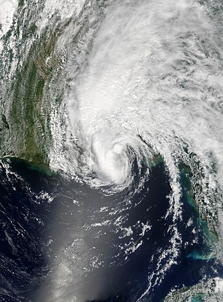
Hurricane Wilma was the most intense tropical cyclone ever recorded in the Atlantic basin, and the second-most intense tropical cyclone recorded in the Western Hemisphere, after Hurricane Patricia in 2015. Part of the record-breaking 2005 Atlantic hurricane season, which included three of the ten most intense Atlantic hurricanes in terms of barometric pressure, Wilma was the twenty-second storm, thirteenth hurricane, sixth major hurricane, fourth Category 5 hurricane, and the second-most destructive hurricane of the 2005 season. Its origins came from a tropical depression that formed in the Caribbean Sea near Jamaica on October 15, headed westward, and intensified into a tropical storm two days later, which abruptly turned southward and was named Wilma. Wilma continued to strengthen, and eventually became a hurricane on October 18. Shortly thereafter, explosive intensification occurred, and in only 24 hours, Wilma became a Category 5 hurricane with wind speeds of 185 mph (298 km/h).

<span class="mw-page-title-main">Hurricane Irene (1999)</span> Category 2 Atlantic hurricane

Hurricane Irene produced somewhat heavy damage across southern Florida in October 1999. The ninth named storm and the sixth hurricane of the season, Irene developed in the western Caribbean Sea on October 13 from a tropical wave. It moved northward, hitting western Cuba before attaining hurricane status. Irene struck Florida on October 15 as a Category 1 on the Saffir–Simpson Hurricane Scale, first at Key West and later near Cape Sable. The storm moved across the state and tracked northward over the Gulf Stream. It approached the Carolinas but remained offshore. Irene turned eastward and significantly intensified into a strong Category 2 hurricane on October 18. By the following day, the system became extratropical due to cooler waters to the southeast of Newfoundland and was quickly absorbed by another extratropical low.

<span class="mw-page-title-main">Tropical Storm Arlene (2005)</span> Atlantic tropical storm in 2005

Tropical Storm Arlene was an unusually large and early-forming tropical storm, being the first of twenty-eight different storms during the 2005 Atlantic hurricane season, which would become the second most active season on record. Tropical Storm Arlene formed near Honduras on June 8 and moved northwards. It crossed western Cuba on June 10 and strengthened to just under hurricane strength before making its final landfall on the Florida Panhandle the next day. The storm weakened as it continued to move north over the United States, becoming extratropical on June 13. Arlene was responsible for two deaths and minor damage.

<span class="mw-page-title-main">Tropical Storm Leslie (2000)</span> Atlantic tropical storm in 2000

Tropical Storm Leslie was a weak, short-lived tropical cyclone that was never well-organized; however, its precursor was costlier than any other tropical cyclone in the 2000 Atlantic hurricane season. The twelfth named storm of the season, Leslie formed on October 4 over eastern Florida as a subtropical cyclone, out of a trough of low pressure. Strengthening over open waters, it attained enough tropical characteristics to be reclassified as Tropical Storm Leslie on October 5. The storm reached peak winds of 45 mph (75 km/h) before wind shear weakened it, and on October 7 transitioned into an extratropical cyclone over the open Atlantic Ocean. Leslie lasted three more days before losing its identity.

<span class="mw-page-title-main">Effects of Hurricane Katrina in Florida</span>

The effects of Hurricane Katrina in Florida were in both the southern portion of the state and in the panhandle. After developing on August 23, Katrina made landfall near the border of Broward and Miami-Dade counties with 80 mph (130 km/h) winds on August 25. While it was crossing the state, the hurricane's convection was asymmetrical, primarily located to the south and east of the center. As a result, high rainfall totals occurred in the Miami area, peaking at 16.43 in (417 mm) in Perrine. The rains caused flooding, and the combination of rains and winds downed trees and power lines, leaving 1.45 million people without power. Damage in South Florida was estimated at $523 million (2005 USD), mostly as a result of crop damage. Further south, the hurricane spawned a tornado in the Florida Keys. In the island chain, Katrina caused heavy rainfall and gusty winds.

<span class="mw-page-title-main">Hurricane Andrew</span> Category 5 Atlantic hurricane in 1992

Hurricane Andrew was a compact, but very powerful and destructive Category 5 Atlantic hurricane that struck the Bahamas, Florida, and Louisiana in August 1992. It is the most destructive hurricane to ever hit Florida in terms of structures damaged or destroyed, and remained the costliest in financial terms until Hurricane Irma surpassed it 25 years later. Andrew was also the strongest landfalling hurricane in the United States in decades and the costliest hurricane to strike anywhere in the country, until it was surpassed by Katrina in 2005. In addition, Andrew is one of only four tropical cyclones to make landfall in the continental United States as a Category 5, alongside the 1935 Labor Day hurricane, 1969's Camille, and 2018's Michael. While the storm also caused major damage in the Bahamas and Louisiana, the greatest impact was felt in South Florida, where the storm made landfall as a Category 5 hurricane, with 1-minute sustained wind speeds as high as 165 mph (266 km/h) and a gust as high as 174 mph (280 km/h). Passing directly through the cities of Cutler Bay and Homestead in Dade County, the hurricane stripped many homes of all but their concrete foundations and caused catastrophic damage. In total, Andrew destroyed more than 63,500 houses, damaged more than 124,000 others, caused $27.3 billion in damage, and left 65 people dead.

<span class="mw-page-title-main">Effects of Hurricane Isaac in Florida</span>

The effects of Hurricane Isaac in Florida were severe local flooding in South Florida and tornadoes in Central and Northern Florida in August 2012. Hurricane Isaac formed from a tropical wave while located east of the Lesser Antilles on August 21, 2012. The storm moved westward, crossed through the Leeward Islands, and entered the Caribbean Sea on August 22. Isaac initially struggled to intensify and defied predictions of it strengthening into a hurricane. The storm made its first landfall in Haiti as a midgrade tropical storm prior to making a second one in Cuba later that day. It remained somewhat disorganized while moving through the Straits of Florida and passed near the Florida Keys on August 27. The storm threatened to strike the Tampa Bay Area during the 2012 Republican National Convention and move ashore in the Florida Panhandle as a major hurricane. However, it continued northwestward and avoided landfall in the state. The storm finally became a hurricane late on August 28. Isaac made two landfalls in Louisiana on August 29, the first near the mouth of the Mississippi River and the other near Port Fourchon. The storm steadily weakened and eventually dissipated over Missouri on September 1.

<span class="mw-page-title-main">Tropical Storm Andrea (2013)</span> Atlantic Tropical storm in the 2013

Tropical Storm Andrea brought flooding to Cuba, the Yucatan Peninsula, and portions of the East Coast of the United States in June 2013. The first tropical cyclone and named storm of the annual hurricane season, Andrea originated from an area of low pressure in the eastern Gulf of Mexico on June 5. Despite strong wind shear and an abundance of dry air, the storm strengthened while initially heading north-northeastward. Later on June 5, it re-curved northeastward and approached the Big Bend region of Florida. Andrea intensified and peaked as a strong tropical storm with winds at 65 mph (105 km/h) on June 6. A few hours later, the storm weakened slightly and made landfall near Steinhatchee, Florida later that day. It began losing tropical characteristics while tracking across Florida and Georgia. Andrea transitioned into an extratropical cyclone over South Carolina on June 7, though the remnants continued to move along the East Coast of the United States, until being absorbed by another extratropical system offshore Maine on June 10.

<span class="mw-page-title-main">Tropical Storm Erika</span> Atlantic tropical storm in 2015

Tropical Storm Erika was one of the deadliest and most destructive natural disasters in Dominica since Hurricane David in 1979. The fifth named storm of the 2015 Atlantic hurricane season, Erika developed from a westward-moving tropical wave while well east of the Lesser Antilles. Hostile conditions, including dry air and wind shear, inhibited significant development, and Erika failed to acquire sustained winds beyond 50 mph (80 km/h). Contrary to predictions of a northwesterly recurvature, the cyclone persisted on a westerly course and passed through the Leeward Islands and emerged over the Caribbean Sea on August 27. Erika succumbed to adverse conditions the following day, dissipating as a tropical cyclone near the Dominican Republic. The remnant system persisted for several more days, moving into the northeastern Gulf of Mexico, before dissipating over Georgia on September 3.

<span class="mw-page-title-main">Effects of Hurricane Floyd in Florida</span>

Hurricane Floyd in 1999 threatened Florida as a major hurricane roughly three times as large as Hurricane Andrew. Floyd originated from a tropical wave well east of the Lesser Antilles on September 7. While approaching the Bahamas, the storm strengthened significantly between September 12 and September 13. On the latter day, Floyd peaked as a strong Category 4 hurricane on the Saffir–Simpson scale. However, upon moving closer to the Bahamas, the storm fluctuated in intensity between a Category 3 and a Category 4 hurricane. A subtropical ridge eroded by a mid- to upper-tropospheric trough over the eastern United States caused Floyd to curve northwestward over the Abaco Islands and later to northeast, avoiding a potentially catastrophic landfall in Florida. The storm made its closest approach to Florida early on September 15, passing about 110 mi (180 km) east of Cape Canaveral.

<span class="mw-page-title-main">Tropical Storm Colin (2016)</span> Atlantic tropical storm in 2016

Tropical Storm Colin was the earliest third named storm in the Atlantic basin on record for four years, until it was surpassed by Tropical Storm Cristobal in 2020. An atypical, poorly organized tropical cyclone, Colin developed from a low pressure area over the Gulf of Mexico near the northern coast of the Yucatán Peninsula late on June 5, 2016. Moving northward, the depression strengthened into a tropical storm about eight hours after its formation. On June 6, Colin curved to the north-northeast and intensified slightly to winds of 50 mph (80 km/h). Strong wind shear prevented further strengthening and resulted in the system maintaining a disheveled appearance on satellite imagery. Later, the storm began accelerating to the northeast. Early on June 7, Colin made landfall in rural Taylor County, Florida, still at peak intensity. The system rapidly crossed northern Florida and emerged into the Atlantic Ocean several hours later. By late on June 7, Colin transitioned into an extratropical cyclone offshore North Carolina before being absorbed by a frontal boundary the following day.

<span class="mw-page-title-main">Hurricane Matthew</span> Category 5 Atlantic hurricane in 2016

Hurricane Matthew was an extremely powerful Atlantic hurricane which caused catastrophic damage and a humanitarian crisis in Haiti, as well as widespread devastation in the southeastern United States. The deadliest Atlantic hurricane since Hurricane Stan in 2005, and the first Category 5 Atlantic hurricane since Felix in 2007, Matthew was the thirteenth named storm, fifth hurricane and second major hurricane of the 2016 Atlantic hurricane season. It caused extensive damage to landmasses in the Greater Antilles, and severe damage in several islands of the Bahamas which were still recovering from Joaquin, which had pounded the archipelago nearly a year earlier. Matthew also approached the southeastern United States, but stayed just offshore, paralleling the Florida coastline.

<span class="mw-page-title-main">Tropical Storm Emily (2017)</span> Tropical cyclone in the 2017 Atlantic hurricane season

Tropical Storm Emily was a rapidly-forming tropical cyclone that made landfall on the west coast of Florida. The fifth named storm of the 2017 Atlantic hurricane season, Emily formed from a small area of low pressure that developed along a cold front in late July 2017. Unexpectedly, the low rapidly organized and strengthened into a tropical depression on July 30, and then into a tropical storm early the next day. Emily continued to intensify as it moved eastward, peaking with maximum sustained winds of 60 mph (95 km/h) as it made landfall near Longboat Key on the western Florida coast. The cyclone weakened quickly into a tropical depression shortly after landfall as its circulation became increasingly disrupted. Emerging into the Atlantic Ocean on August 1, Emily continued to weaken as it accelerated northeastward, becoming post-tropical early on August 2.

<span class="mw-page-title-main">Effects of Hurricane Irma in Florida</span>

Hurricane Irma was the costliest tropical cyclone in the history of the U.S. state of Florida, before being surpassed by Hurricane Ian in 2022. Irma developed from a tropical wave near the Cape Verde Islands on August 30, 2017. The storm quickly became a hurricane on August 31 and then a major hurricane shortly thereafter, but would oscillate in intensity over the next few days. By September 4, Irma resumed strengthening, and became a powerful Category 5 hurricane on the following day. The cyclone then struck Saint Maarten and the British Virgin Islands on September 6 and later crossed Little Inagua in the Bahamas on September 8. Irma briefly weakened to a Category 4 hurricane, but re-intensified into a Category 5 hurricane before making landfall in the Sabana-Camagüey Archipelago of Cuba. After falling to Category 3 status due to land interaction, the storm re-strengthened into a Category 4 hurricane in the Straits of Florida. Irma struck Florida twice on September 10 – the first as a Category 4 at Cudjoe Key and the second on Marco Island as a Category 3. The hurricane weakened significantly over Florida, and was reduced to a tropical storm, before exiting the state into Georgia on September 11.

<span class="mw-page-title-main">Tropical Storm Claudette (2021)</span> Atlantic tropical storm in 2021

Tropical Storm Claudette was a weak tropical cyclone that caused heavy rain and tornadoes across the Southeastern United States in June 2021, leading to severe damage. The third named storm of the 2021 Atlantic hurricane season, Claudette originated from a broad trough of low pressure over the Bay of Campeche on June 12. The disturbance moved erratically over the region for the next several days, before proceeding northward with little development due to unfavorable upper-level winds and land interaction. Despite this, the National Hurricane Center (NHC) initiated advisories on it as a Potential Tropical Cyclone late on June 17, due to its imminent threat to land. The disturbance finally organized into Tropical Storm Claudette at 00:00 UTC on June 19 just before landfall in southeast Louisiana. Claudette weakened to a depression as it turned east-northeastward before moving through Mississippi, Alabama, Georgia, and South Carolina. Baroclinic forcing then caused Claudette to reintensify into a tropical storm over North Carolina early on June 21 before it accelerated into the Atlantic Ocean later that day. Soon afterward, it degenerated into a low-pressure trough on the same day, before being absorbed into another extratropical cyclone on the next day.

<span class="mw-page-title-main">Hurricane Ian</span> Category 5 Atlantic hurricane in 2022

Hurricane Ian was a deadly and extremely destructive Category 5 Atlantic hurricane, which was the third-costliest weather disaster on record worldwide, the deadliest hurricane to strike the state of Florida since the 1935 Labor Day hurricane, and the strongest hurricane to make landfall in Florida since Michael in 2018. Ian caused widespread damage across western Cuba, Florida, and the Carolinas. Ian was the ninth named storm, fourth hurricane, and second major hurricane of the 2022 Atlantic hurricane season. Ian was the first Category 5 hurricane in the Atlantic since Lorenzo in 2019.

<span class="mw-page-title-main">Hurricane Nicole (2022)</span> Category 1 Atlantic hurricane in 2022

Hurricane Nicole was a sprawling late-season Category 1 hurricane in November 2022. The fourteenth named storm and eighth hurricane of the 2022 Atlantic hurricane season, Nicole formed as a subtropical cyclone on November 7, from a non-tropical area of low pressure near the Greater Antilles, and transitioned into a tropical cyclone the next day. Then, taking a path similar to that of Hurricane Dorian three years earlier, Nicole made landfall on November 9, on Great Abaco and on Grand Bahama in The Bahamas, where it strengthened into a Category 1 hurricane. On November 10, it made landfall twice in Florida, south of Vero Beach and then northwest of Cedar Key, after briefly emerging over the Gulf of Mexico. Nicole then weakened to a depression while moving over the Florida Panhandle, and then was absorbed into a mid-latitude trough and cold front over extreme eastern Tennessee the following day.

References

  1. Daniel Brown (September 28, 2016). Tropical Storm Matthew Discussion Number 1 (Report). National Hurricane Center. Retrieved September 30, 2016.
  2. 1 2 3 4 Stacy R. Stewart (April 3, 2017). Hurricane Matthew (AL142016) (PDF) (Report). Tropical Cyclone Report. National Hurricane Center. Retrieved April 6, 2017.
  3. Scott, Rick (September 30, 2016). "Gov. Scott: As Hurricane Matthew Strengthens to Cat 4, Residents Must Be Prepared" (PDF) (Press release). Miami, Florida: Florida Division of Emergency Management . Retrieved February 27, 2017.
  4. Scott, Rick (October 1, 2016). "Gov. Cat 4 Hurricane Matthew Is Life Threatening; Floridians Must Remain Vigilant" (PDF) (Press release). Miami, Florida: Florida Division of Emergency Management . Retrieved February 27, 2017.
  5. "Cat 4 Hurricane Matthew May Threaten Florida; Stay Alert And Prepare Now" (PDF) (Press release). Miami, Florida: Florida Division of Emergency Management. October 2, 2016. Retrieved February 27, 2017.
  6. Scott, Rick (October 3, 2016). "Gov. Scott: Cat 4 Hurricane Matthew Is Life Threatening And Approaching Florida" (PDF) (Press release). Miami, Florida: Florida Division of Emergency Management . Retrieved February 27, 2017.
  7. "Gov. Scott Issues Updates on Hurricane Matthew Preparedness Efforts as Storm Approaches Florida" (PDF) (Press release). Miami, Florida: Florida Division of Emergency Management. October 4, 2016. Retrieved February 27, 2017.
  8. Everglades National Park Closing Due to Hurricane Matthew, NPS.gov, October 4, 2016
  9. Biscayne National Park Closure for Hurricane Matthew, NPS.gov, October 4, 2016
  10. 1 2 3 4 5 "Gov. Scott Issues Updates on Hurricane Matthew Preparedness Efforts as Storm Approaches Florida" (PDF) (Press release). Miami, Florida: Florida Division of Emergency Management. October 6, 2016. Retrieved February 27, 2017.
  11. 1 2 3 4 "Gov. Scott Issues Updates on Hurricane Matthew Preparedness Efforts as Storm Approaches Florida" (PDF) (Press release). Miami, Florida: Florida Division of Emergency Management. October 5, 2016. Retrieved February 27, 2017.
  12. 1 2 Scott, Rick (October 5, 2016). "Gov. Scott Requests Emergency Declaration From President; Suspends Tolls; Calls Up More National Guard Members" (PDF) (Press release). Miami, Florida: Florida Division of Emergency Management . Retrieved February 27, 2017.
  13. Scott, Rick (October 6, 2016). "Gov. Scott: Over Half Of The National Guard Activated; Additional Requests To President" (PDF) (Press release). Miami, Florida: Florida Division of Emergency Management . Retrieved February 27, 2017.
  14. 1 2 Scott, Rick (October 5, 2016). "Gov. Scott: Directing Suspension Of Tolls; National Guard Deployments" (PDF) (Press release). Miami, Florida: Florida Division of Emergency Management . Retrieved February 27, 2017.
  15. "Gov. Scott Issues Updates on Hurricane Matthew Preparedness Efforts as Storm Approaches Florida" (PDF) (Press release). Miami, Florida: Florida Division of Emergency Management. October 6, 2016. Retrieved February 27, 2017.
  16. "Florida evacuations, closures due to Hurricane Matthew". NBC2. October 7, 2016. Retrieved March 1, 2017.
  17. Fields, Tammie (October 7, 2016). "Tampa airport to absorb many flights impacted by Hurricane Matthew". Tampa, Florida: WTSP. Retrieved March 6, 2017.
  18. Berman, Dave (October 4, 2016). "Port Canaveral closing to ships, business on Wednesday". Florida Today . Retrieved October 6, 2016.
  19. 1 2 Dean, James (October 4, 2016). "KSC, Cape Canaveral AFS preparing for Hurricane Matthew". Florida Today. Retrieved October 6, 2016.
  20. Berger, Eric (October 4, 2016). "Hurricane Matthew poses a significant threat to Kennedy Space Center". Ars Technica. Retrieved October 6, 2016.
  21. 1 2 Sarkissian, Arek; Gallop, J.D.; Stangli, Doug (October 6, 2016). "Hurricane Matthew: Florida governor says 'Evacuate, evacuate, evacuate'". USAToday . Melbourne, Florida. Retrieved March 1, 2017.
  22. Avila, Lixion (October 5, 2016). Hurricane Matthew Discussion Number 031 (Report). Miami, Florida: National Hurricane Center . Retrieved March 1, 2017.
  23. Ovalle, David; Staletovich, Jenny; Nehamas, Nicholas (October 6, 2016). "Hurricane Matthew now Cat 3, still threat to Florida". Miami Herald . Retrieved March 3, 2017.
  24. Neuhaus, Les (October 7, 2016). "Many Florida Beach Residents Shrug Off Evacuation Orders". The New York Times . Jacksonville Beach, Florida. Retrieved March 1, 2017.
  25. Avila, Lixion (October 4, 2016). Hurricane Matthew Advisory Number 026 (Report). Miami, Florida: National Hurricane Center . Retrieved March 1, 2017.
  26. Stewart, Stacy (October 4, 2016). Hurricane Matthew Tropical Cyclone Update: Hurricane Watch Issued for Lake Okeechobee (Report). Miami, Florida: National Hurricane Center . Retrieved March 1, 2017.
  27. Stewart, Stacy (October 4, 2016). Hurricane Matthew Advisory Number 028 (Report). Miami, Florida: National Hurricane Center . Retrieved March 1, 2017.
  28. Brown, Daniel; Cangialosi, John (October 5, 2016). Hurricane Matthew Advisory Number 029 (Report). Miami, Florida: National Hurricane Center . Retrieved March 1, 2017.
  29. Avila, Lixion (October 5, 2016). Hurricane Matthew Advisory Number 030 (Report). Miami, Florida: National Hurricane Center . Retrieved March 1, 2017.
  30. Beven, John (October 6, 2016). Hurricane Matthew Advisory Number 032 (Report). Miami, Florida: National Hurricane Center . Retrieved March 1, 2017.
  31. Avila, Lixion (October 5, 2016). Hurricane Matthew Advisory Number 031 (Report). Miami, Florida: National Hurricane Center . Retrieved March 1, 2017.
  32. Avila, Lixion (October 6, 2016). Hurricane Matthew Advisory Number 034 (Report). Miami, Florida: National Hurricane Center . Retrieved March 1, 2017.
  33. Avila, Lixion (October 7, 2016). Hurricane Matthew Advisory Number 038 (Report). Miami, Florida: National Hurricane Center . Retrieved March 1, 2017.
  34. Avila, Lixion (October 8, 2016). Hurricane Matthew Advisory Number 042 (Report). Miami, Florida: National Hurricane Center . Retrieved March 1, 2017.
  35. Menzer, Joe (October 7, 2016). "Rain washes out XFINITY race, all Friday activities at Charlotte". Fox Sports . Retrieved October 8, 2016.
  36. Jensen, Tom (October 8, 2016). "NASCAR Sprint Cup race at Charlotte postponed until Sunday". Fox Sports . Retrieved October 8, 2016.
  37. https://amp.miamiherald.com/sports/nhl/florida-panthers/article106140602.html
  38. "Hurricane Matthew forces Disney World to close for 4th time ever". USA Today. Retrieved October 10, 2016.
  39. "Hurricane Matthew – Theme Park Closings and Updates – Attractions Magazine". Attractions Magazine. October 6, 2016. Retrieved October 6, 2016.
  40. 1 2 "Hurricane Matthew Claims Data". Florida Office of Insurance Regulation. March 3, 2017. Archived from the original on March 20, 2017. Retrieved March 13, 2017.
  41. "[Florida Event Reports related to Hurricane Matthew]". National Centers for Environmental Information. 2017. Retrieved February 27, 2017.
  42. 1 2 3 Salisbury, Susan (February 7, 2017). "FPL customers to be billed for Hurricane Matthew costs starting in March". Palm Beach Post. Retrieved March 12, 2017.
  43. "Hurricanes Matthew, Hermine caused $1.6 billion in damage". Florida Today. Tallahassee, Florida. December 16, 2016. Retrieved March 6, 2017.
  44. "Gov. Scott Issues Updates on Hurricane Matthew Preparedness and Response Efforts as Storm Continues to Impact Florida" (PDF) (Press release). Florida Division of Emergency Management. October 7, 2016. Retrieved March 17, 2017.
  45. 1 2 3 Florida Event Report: High Surf (Report). National Centers for Environmental Information. 2017. Retrieved March 1, 2017.{{cite report}}: Unknown parameter |agency= ignored (help)
  46. 1 2 3 Florida Event Report: Tropical Storm (Report). National Centers for Environmental Information. 2017. Retrieved March 1, 2017.{{cite report}}: Unknown parameter |agency= ignored (help)
  47. 1 2 Florida Event Report: Tropical Depression (Report). National Centers for Environmental Information. 2017. Retrieved March 1, 2017.{{cite report}}: Unknown parameter |agency= ignored (help)
  48. Florida Event Report: Tropical Depression (Report). National Centers for Environmental Information. 2017. Retrieved March 1, 2017.{{cite report}}: Unknown parameter |agency= ignored (help)
  49. Preliminary Local Storm Report...Summary (Report). Miami, Florida: Iowa Environmental Mesonet National Weather Service. October 7, 2016. Retrieved March 1, 2017.{{cite report}}: Unknown parameter |agency= ignored (help)
  50. 1 2 Florida Event Report: Tropical Depression (Report). National Centers for Environmental Information. 2017. Retrieved March 1, 2017.{{cite report}}: Unknown parameter |agency= ignored (help)
  51. Florida Event Report: Tropical Depression (Report). National Centers for Environmental Information. 2017. Retrieved March 1, 2017.{{cite report}}: Unknown parameter |agency= ignored (help)
  52. "Multiple Injuries in Officer-Involved Car Crash in Miami". NBC6. October 6, 2016. Retrieved March 12, 2017.
  53. Rabin, Charles; Teproff, Carli (October 6, 2016). "9 people injured in crash between a cop car and an Audi carrying 8 people". Miami Herald. Retrieved March 12, 2017.
  54. "One injured after car hits pole in Boca Raton". Boca Raton, Florida: WPTV. October 7, 2016. Retrieved March 12, 2017.
  55. Piccardo, Rebeca (October 5, 2016). "Hurricane shutters fall on man in Weston". Sun Sentinel. Weston, Florida. Retrieved March 12, 2017.
  56. Florida Event Report: High Surf (Report). National Centers for Environmental Information. 2017. Retrieved March 1, 2017.{{cite report}}: Unknown parameter |agency= ignored (help)
  57. "Hurricane Matthew destroys 800 turtle nests near West Palm Beach". Naples Daily News. Juno Beach, Florida. The Associated Press. October 12, 2016. Retrieved March 12, 2016.
  58. Milberg, Glenna (October 13, 2016). "Sand movement during Hurricane Matthew replenishes portion of Miami Beach". Miami Beach, Florida: WPLG. Retrieved March 17, 2017.
  59. Florida Event Report: High Surf (Report). National Centers for Environmental Information. 2017. Retrieved March 1, 2017.{{cite report}}: Unknown parameter |agency= ignored (help)
  60. "7 Deaths, 2 in Miami-Dade, Related to Hurricane Matthew: Officials". NBC6. October 10, 2016. Retrieved March 12, 2017.
  61. Ballou, Brian (October 9, 2016). "Man falls off ladder while removing hurricane shutters". Sun Sentinel. Retrieved March 12, 2017.
  62. Florida Event Report: Coastal Flood (Report). National Centers for Environmental Information. 2017. Retrieved March 1, 2017.{{cite report}}: Unknown parameter |agency= ignored (help)
  63. Florida Event Report: Tropical Storm (Report). National Centers for Environmental Information. 2017. Retrieved March 6, 2017.{{cite report}}: Unknown parameter |agency= ignored (help)
  64. Florida Event Report: Tropical Storm (Report). National Centers for Environmental Information. 2017. Retrieved March 6, 2017.{{cite report}}: Unknown parameter |agency= ignored (help)
  65. Florida Event Report: Tropical Storm (Report). National Centers for Environmental Information. 2017. Retrieved March 6, 2017.{{cite report}}: Unknown parameter |agency= ignored (help)
  66. Florida Event Report: Tropical Storm (Report). National Centers for Environmental Information. 2017. Retrieved March 6, 2017.{{cite report}}: Unknown parameter |agency= ignored (help)
  67. Florida Event Report: Tropical Storm (Report). National Centers for Environmental Information. 2017. Retrieved March 6, 2017.{{cite report}}: Unknown parameter |agency= ignored (help)
  68. 1 2 3 4 Florida Event Report: Hurricane (Report). National Centers for Environmental Information. 2017. Retrieved March 6, 2017.{{cite report}}: Unknown parameter |agency= ignored (help)
  69. "Florida woman is 1st Hurricane Matthew-related death in U.S." WGN-TV. CNN Wire. October 7, 2016. Retrieved March 13, 2017.
  70. Shainman, Jon (October 7, 2016). "Two storm-related deaths in St. Lucie County, fire rescue says". St. Lucie County, Florida: WPTV. Retrieved March 13, 2017.
  71. "Hurricane Matthew: Florida couple dies of generator fumes; U.S. death toll at 4". Cape Canaveral, Florida: WDBJ. The Associated Press. October 7, 2016. Retrieved March 13, 2017.
  72. Gardner, Keona (October 14, 2016). "St. Lucie: Hurricane Matthew caused $9.3M in damage". Treasure Coast Palm. St. Lucie County, Florida. Retrieved March 12, 2017.
  73. "2nd death reported during Hurricane Matthew". Orange County, Florida: Fox4. October 8, 2016. Archived from the original on October 14, 2016. Retrieved March 13, 2017.
  74. 1 2 3 Florida Event Report: Hurricane (Report). National Centers for Environmental Information. 2017. Retrieved March 12, 2017.{{cite report}}: Unknown parameter |agency= ignored (help)
  75. 1 2 Florida Event Report: Storm Surge/Tide (Report). National Centers for Environmental Information. 2017. Retrieved March 12, 2017.{{cite report}}: Unknown parameter |agency= ignored (help)
  76. 1 2 Dean, James (October 12, 2016). "Hurricane Matthew at KSC: Millions in damages". Florida Today. Retrieved October 12, 2016.
  77. Kennedy Space Center (October 18, 2016). "[Damage to the Vehicle Assembly Building at Kennedy Space Center]". Flickr. Retrieved March 7, 2017.
  78. Pearlman, Robert (October 10, 2016). "NASA Artifacts, Historic Facilities Damaged by Hurricane Matthew: Photos". space.com. Retrieved March 7, 2017.
  79. Marco Santana (October 11, 2016). "Hurricane Matthew challenged latest prediction tech". Orlando Sentinel. Retrieved October 12, 2016.
  80. Santana, Marco. "NASA's GOES-R satellite launch delayed again". OrlandoSentinel.com.
  81. "Pegasus launches hurricane-hunting satellites for NASA". USA TODAY.
  82. King, Ledyard (December 10, 2016). "Senate OKs $2 billion for Glades, $74 million for Kennedy Space Center". Citizen Times. Washington, D.C. Retrieved March 7, 2017.
  83. Florida Event Report: Storm Surge/Tide (Report). National Centers for Environmental Information. 2017. Retrieved March 7, 2017.{{cite report}}: Unknown parameter |agency= ignored (help)
  84. 1 2 3 4 Florida Event Report: Tropical Storm (Report). National Centers for Environmental Information. 2017. Retrieved March 17, 2017.{{cite report}}: Unknown parameter |agency= ignored (help)
  85. Roth, David (2016). "[Hurricane Matthew Rainfall Graphic]" (.GIF). Weather Prediction Center. Retrieved March 17, 2017.
  86. 1 2 3 Florida Event Report: Tropical Storm (Report). National Centers for Environmental Information. 2017. Retrieved March 17, 2017.{{cite report}}: Unknown parameter |agency= ignored (help)
  87. "Four Florida deaths blamed on Hurricane Matthew". Cape Canaveral, Florida: WOWT. The Associated Press. October 7, 2016. Retrieved March 12, 2017.
  88. Leigh, Heather (October 12, 2016). "FEMA evaluates hurricane damage in Putnam County". Putnam County, Florida: News4Jax. Retrieved March 17, 2017.
  89. 1 2 3 "Gov. Scott Issues Updates on Hurricane Matthew Response and Recovery Efforts" (PDF) (Press release). Florida Division of Emergency Management. October 8, 2016. Retrieved March 17, 2017.
  90. Florida Event Report: Tropical Storm (Report). National Centers for Environmental Information. 2017. Retrieved March 17, 2017.{{cite report}}: Unknown parameter |agency= ignored (help)
  91. Florida Event Report: Tropical Storm (Report). National Centers for Environmental Information. 2017. Retrieved March 17, 2017.{{cite report}}: Unknown parameter |agency= ignored (help)
  92. "Gov. Scott Issues Updates on Hurricane Matthew Response and Recovery Efforts" (PDF) (Press release). Florida Division of Emergency Management. October 7, 2016. Retrieved March 17, 2017.
  93. Williams, David (October 10, 2016). "At least 200 mobile homes damaged in Flagler Beach along with severe damage to A1A where parts of the highway fell into the ocean in south Flagler Beach". Flagler Beach, Florida: Fox35. Retrieved March 13, 2017.
  94. "Hurricane Matthew washes away parts of A1A in Flagler County". WFTV 9 . October 7, 2016. Retrieved November 8, 2022.
  95. Bruce, Matt (October 8, 2016). "Flagler loses part of A1A but 'dodges bullet'". The Daytona Beach News-Journal . Retrieved November 8, 2022.
  96. "Jacksonville man falls off roof while doing repairs during Hurricane Matthew, dies". Jacksonville, Florida: WTLV. October 7, 2016. Retrieved March 13, 2017.
  97. Micolucci, Vic (October 26, 2016). "Officer's leg amputated after Hurricane Matthew cleanup injury". Jacksonville, Florida: News4Jax. Retrieved March 13, 2017.
  98. Gardner, Lynnsey; Minor, Tarik; Parenteau, Chris; Harris, Jenese (October 8, 2016). "St. Johns County estimates $2B in damage". St. Augustine, Florida: News4Jax. Retrieved March 13, 2017.
  99. Gomez, Alan (October 7, 2016). "Hurricane Matthew causes little damage in Miami-Dade, Broward and Palm Beach". USAToday. West Palm Beach, Florida. Retrieved March 17, 2017.
  100. Florida – Hurricane Matthew FEMA-4283-DR (PDF). Federal Emergency Management Agency (Report). October 8, 2016. Retrieved March 20, 2017.
  101. "FEMA-4283-DR, Florida Disaster Declaration as of 11/04/2016" (PDF). Federal Emergency Management Agency. November 4, 2016. Retrieved March 20, 2017.
  102. Disaster recovery centers:
  103. FEMA Extends Deadline for Flood Insurance Claims following Hurricane Matthew (Report). Federal Emergency Management Agency. February 3, 2017. Retrieved March 20, 2017.
  104. "Florida Hurricane Matthew (DR-4283)". Federal Emergency Management Agency. March 20, 2017. Retrieved March 20, 2017.