
Stephenson County is a county located in the U.S. state of Illinois. According to the 2010 United States Census, it had a population of 47,711. Its county seat is Freeport.
Izard County is a county located in the U.S. state of Arkansas. As of the 2010 census, the population was 13,696. The county seat is Melbourne. Izard County is Arkansas's 13th county, formed on October 27, 1825, and named for War of 1812 General and Arkansas Territorial Governor George Izard. It is an alcohol prohibition or dry county.
Freeport is a village in the Town of Hempstead, in Nassau County, on the South Shore of Long Island, in New York, United States. The population was 43,713 at the 2010 census, making it the second largest village in New York by population.

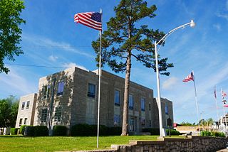
Freeport is a city in Brazoria County, Texas, United States, located on the Gulf of Mexico. According to the 2020 census, the city population was 10,696, down from 12,049 in 2010.

Quintana is a town in Brazoria County, Texas, United States. Its population was 56 at the 2010 census.

Surfside Beach, also known locally as Surfside, is a city in Brazoria County, Texas, United States, that is situated on Follet's Island by the Gulf of Mexico near the city of Freeport. The population was 482 at the 2010 census. The city has claimed the "Cradle of Texas Liberty" title due to the fact that the Treaty of Velasco which ended hostilities between Texas and Mexico was signed at Fort Velasco, which was located near the city's current City Hall.

Brussels is a town in Door County, Wisconsin, United States. The population was 1,136 at the 2010 census. The unincorporated communities of Brussels and Kolberg are located in the town. The unincorporated community of Rosiere is also located partially in the town.
Rock Hill is a high point in Florida. This hill is located in Walton County, Florida. The hill is 193 feet high. Just outside Eglin Air Force Base, Rock Hill is 5 miles (8.0 km) north of Freeport, Florida; and is 7 miles (11 km) south of DeFuniak Springs, Florida, near the intersection of U.S. Route 331 and State Road 20. Its exact location is 30°36'2"N 86°6'22"W.

East Grand Bahama is a district of the Bahamas, situated on the eastern part of the island of Grand Bahama.
Méguet is a town in the Méguet Department in Ganzourgou Province in central Burkina Faso. The population of Méguet is 7,273 and it is the capital of Méguet Department.
Sideling Hill Creek is a 25.2-mile-long (40.6 km) tributary stream of the Potomac River in the U.S. states of Maryland and Pennsylvania. Sideling Hill Creek flows southward along the western flanks of Sideling Hill, from which the stream takes its name. It forms the boundary between Allegany and Washington counties in Maryland.
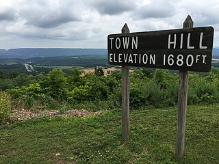
Town Hill is a mountain range located in Allegany County, Maryland and Bedford and Fulton Counties in Pennsylvania. Its southern end is 2.25 miles northwest of Kiefer in Allegany County. It trends northeasterly, and ends about 1.5 miles south of the town of Emmaville in Fulton County. Its highest elevation is 2000 feet.

Altamira is a town and municipality in the Huila Department, Colombia.

Maungdaw is a town in Rakhine State, in the western part of Myanmar (Burma). It is the administrative seat of Maungdaw Township and Maungdaw District. Maungdaw is a town of Myanmar and borders Bangladesh. Maungdaw is 16 miles north of Buthidaung. The two towns are separated by the May Yu Mountains and are connected by two tunnels built in 1918. The district around Maungdaw houses a large Royhingya population.
Curries Woods is a neighborhood in the southern part of Greenville in Jersey City, New Jersey bordering Bayonne. It was named after James Curie, who was on the town Committee for Greenville when it was its own Township in the 19th century. The area remained rural until the later part of the century when the Central Railroad of New Jersey built a line connecting ferries to Elizabeth, New Jersey and New York City. Currie's Woods still remained untouched through the late part of the century and it was valued for its woods, rocky shore and dunes on Newark Bay. A lot of the land was eventually lost, but a tract was set aside in the early part of the 20th century. A small cemetery, the Old Greenville Cemetery, was nearby. This park lost much of its land to the city's largest Housing Authority project in 1959, except a small tract in Bayonne, Mercer Park.
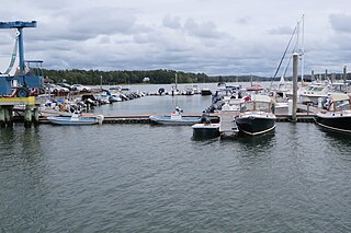
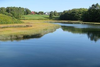
The Harraseeket River is a 3.2-mile-long (5.1 km) tidal river in the town of Freeport within the U.S. state of Maine. It forms a northern arm of Casco Bay.
Little River is a 4.1-mile-long (6.6 km) tributary of Casco Bay in Maine, United States.
The Sabattus River is an 11.4-mile-long (18.3 km) tributary of the Androscoggin River in Maine. It rises at the outlet of Sabattus Pond in the town of Sabattus and flows south into the town of Lisbon, reaching the Androscoggin just southeast of Lisbon Center and about 1.5 miles (2.4 km) upstream (northwest) of Lisbon Falls. Via the Androscoggin River, water from the Sabattus River flows to the Kennebec River at Merrymeeting Bay and ultimately to the Atlantic Ocean.
