Tocobaga was the name of a chiefdom, its chief, and its principal town during the 16th century. The chiefdom was centered around the northern end of Old Tampa Bay, the arm of Tampa Bay that extends between the present-day city of Tampa and northern Pinellas County. The exact location of the principal town is believed to be the archeological Safety Harbor site, which gives its name to the Safety Harbor culture, of which the Tocobaga are the most well-known group.

Spanish Florida was the first major European land claim and attempted settlement in North America during the European Age of Discovery. La Florida formed part of the Captaincy General of Cuba, the Viceroyalty of New Spain, and the Spanish Empire during Spanish colonization of the Americas. While its boundaries were never clearly or formally defined, the territory was initially much larger than the present-day state of Florida, extending over much of what is now the southeastern United States, including all of present-day Florida plus portions of Georgia, Alabama, Mississippi, North Carolina, South Carolina, and Louisiana. Spain's claim to this vast area was based on several wide-ranging expeditions mounted during the 16th century. A number of missions, settlements, and small forts existed in the 16th and to a lesser extent in the 17th century; they were eventually abandoned due to pressure from the expanding English and French colonial settlements, the collapse of the native populations, and the general difficulty in becoming agriculturally or economically self-sufficient. By the 18th century, Spain's control over La Florida did not extend much beyond a handful of forts near St. Augustine, St. Marks, and Pensacola, all within the boundaries of present-day Florida.

Mission San Luis de Apalachee was a Spanish Franciscan mission built in 1656 in the Florida Panhandle, two miles west of the present-day Florida Capitol Building in Tallahassee, Florida. It was located in the descendent settlement of Anhaica capital of Apalachee Province. The mission was part of Spain's effort to colonize the Florida Peninsula and to convert the Timucuan and Apalachee Indians to Christianity. The mission lasted until 1704 when it was evacuated and destroyed to prevent its use by an approaching militia of Creek Indians and South Carolinians.

The Apalachee massacre was a series of raids by English colonists from the Province of Carolina and their Indian allies against a largely peaceful population of Apalachee Indians in northern Spanish Florida that took place in 1704, during Queen Anne's War. Against limited Spanish and Indian resistance, a network of missions was destroyed; most of the population either was killed or captured, fled to larger Spanish and French outposts, or voluntarily joined the English.

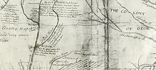
Beginning in the second half of the 16th century, the Kingdom of Spain established a number of missions throughout La Florida in order to convert the Native Americans to Christianity, to facilitate control of the area, and to prevent its colonization by other countries, in particular, England and France. Spanish Florida originally included much of what is now the Southeastern United States, although Spain never exercised long-term effective control over more than the northern part of what is now the State of Florida from present-day St. Augustine to the area around Tallahassee, southeastern Georgia, and some coastal settlements, such as Pensacola, Florida. A few short-lived missions were established in other locations, including Mission Santa Elena in present-day South Carolina, around the Florida peninsula, and in the interior of Georgia and Alabama.
Apalachicola was the name of a Native American tribal town, and of a group of towns associated with it, which the Spanish called Apalachicola Province, located along the lower part of the Chattahoochee River in present-day Alabama and Georgia. It is believed that before the 17th century, the residents of all the Apalachicola towns spoke the Hitchiti language, although other towns whose people spoke the Muscogee language relocated among the Apalachicolas along the Chattahoochee River in the middle- to later- 17th century. All of the Apalachicola towns moved to central Georgia at the end of the 17th century, where the English called them "Ochese Creek Indians". They moved back to the Chattahoochee River after 1715, with the English then calling them "Lower Creeks", while the Spanish called them "Ochese".
Santa Fe de Toloca was a Spanish mission that existed near the Santa Fe River in the northwestern part of what is now Alachua County, Florida, United States during the 17th century. It became an important place on the camino real connecting St. Augustine with Apalachee Province, which was centered on the site of present-day Tallahassee, Florida. The site that the Santa Fe de Toloca mission occupied in the first half of the 17th century was partially excavated in the 1980s.

The Bellamy Road was the first major U.S. federal highway in early territorial Florida.

Antonio Benavides Bazán y Molina was a Lieutenant General in the Spanish Army who held administrative positions in the Americas as Royal Governor of Spanish Florida (1718–1734), Governor of Veracruz (1734–1745), Governor and Captain General of Yucatán province, as well as Governor of Manila in the Philippines. Before his successive appointments to these various positions, he served with distinction in several campaigns of the War of the Spanish Succession in 1710, and perhaps saved the life of Philip V, the first Bourbon King of Spain, at Guadalajara.
Benito Ruíz de Salazar Vallecilla was twice governor of Spanish Florida, from 1645 to 1646 and from 1648 to 1651.
Luis Benedit y Horruytiner was a Spanish colonial administrator who held office as governor of Spanish Florida, and viceroy of Sardinia. He was the uncle of Pedro Benedit Horruytiner, who succeeded him as governor of La Florida.
The Battle of Flint River was a failed attack by Spanish and Apalachee Indian forces against Creek Indians in October 1702 in what is now the state of Georgia. The battle was a major element in ongoing frontier hostilities between English colonists from the Province of Carolina and Spanish Florida, and it was a prelude to more organized military actions of Queen Anne's War.
Spanish West Florida was a province of the Spanish Empire from 1783 until 1821, when both it and East Florida were ceded to the United States.
Tomás Menéndez Márquez y Pedroso (1643–1706) was an official in the government of Spanish Florida, and owner, with his brothers, of the largest ranch in Spanish Florida. He was captured by pirates in 1682 and held for ransom, but was rescued by the Timucua.
Francisco Menéndez Márquez y Posada was a royal treasurer and interim co-governor of Spanish Florida, and the founder of a cattle ranching enterprise that became the largest in Florida.
Juan Fernández de Olivera was the governor of Spanish Florida from 1610 to November 23, 1612. He died in office.
Damián de Vega Castro y Pardo was the governor of the Spanish province of La Florida from November 26, 1638 to April 10, 1645.
Francisco del Moral Sánchez Villegas was the governor of Spanish Florida from mid-1734 to early 1737.
The King's Road was a road built by the British in their colony of East Florida. It stretched from the St. Marys River, the border between East Florida and Georgia, to south of New Smyrna, and was mostly completed by 1773.
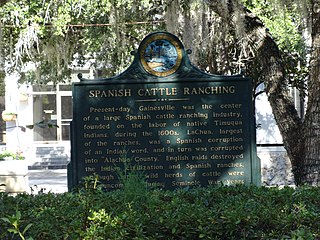
Cattle ranching was an important industry in Spanish Florida in the second half of the seventeenth century. The Spanish were in Florida for almost a century before ranching became widespread in the colony. Late in the seventeenth century, ranches were located along the middle St. Johns River, in Potano Province, and in Apalachee Province. Ranches flourished despite conflicts with the native people of Florida. Attacks by the English colony, the Province of Carolina, and its native allies brought an abrupt end to ranching in Florida at the beginning of the eighteenth century.

