Related Research Articles

The exposed geology of the Capitol Reef area presents a record of mostly Mesozoic-aged sedimentation in an area of North America in and around Capitol Reef National Park, on the Colorado Plateau in southeastern Utah.

The Morrison Formation is a distinctive sequence of Upper Jurassic sedimentary rock found in the western United States which has been the most fertile source of dinosaur fossils in North America. It is composed of mudstone, sandstone, siltstone, and limestone and is light gray, greenish gray, or red. Most of the fossils occur in the green siltstone beds and lower sandstones, relics of the rivers and floodplains of the Jurassic period.

The Cutler Formation or Cutler Group is a rock unit that is exposed across the U.S. states of Arizona, northwest New Mexico, southeast Utah and southwest Colorado. It was laid down in the Early Permian during the Wolfcampian epoch.

The Moenkopi Formation is a geological formation that is spread across the U.S. states of New Mexico, northern Arizona, Nevada, southeastern California, eastern Utah and western Colorado. This unit is considered to be a group in Arizona. Part of the Colorado Plateau and Basin and Range, this red sandstone was laid down in the Lower Triassic and possibly part of the Middle Triassic, around 240 million years ago.

The Chinle Formation is an Upper Triassic continental geological formation of fluvial, lacustrine, and palustrine to eolian deposits spread across the U.S. states of Nevada, Utah, northern Arizona, western New Mexico, and western Colorado. In New Mexico, it is often raised to the status of a geological group, the Chinle Group. Some authors have controversially considered the Chinle to be synonymous to the Dockum Group of eastern Colorado and New Mexico, western Texas, the Oklahoma panhandle, and southwestern Kansas. The Chinle Formation is part of the Colorado Plateau, Basin and Range, and the southern section of the Interior Plains. A probable separate depositional basin within the Chinle is found in northwestern Colorado and northeastern Utah. The southern portion of the Chinle reaches a maximum thickness of a little over 520 meters (1,710 ft). Typically, the Chinle rests unconformably on the Moenkopi Formation.

The Glen Canyon Group is a geologic group of formations that is spread across the U.S. states of Nevada, Utah, northern Arizona, north west New Mexico and western Colorado. It is called the Glen Canyon Sandstone in the Green River Basin of Colorado and Utah.
The Naturita Formation is a classification used in western Colorado and eastern Utah for a Cretaceous Period sedimentary geologic formation. This name was "applied to the upper or carbonaceous part of Dakota Group" by R.G. Young in 1960, naming it for Naturita, Colorado. The name is not used by U.S. Geological Survey authors, but has found growing acceptance by the Utah Geological Survey

The Pennsylvanian Pottsville Formation is a mapped bedrock unit in Pennsylvania, western Maryland, West Virginia, Ohio, and Alabama. It is a major ridge-former in the Ridge-and-Valley Appalachians of the eastern United States. The Pottsville Formation is conspicuous at many sites along the Allegheny Front, the eastern escarpment of the Allegheny or Appalachian Plateau.

The Lower Permian Esplanade Sandstone is a cliff-forming, resistant sandstone, dark red, geologic unit found in the Grand Canyon. The rock unit forms a resistant shelf in the west Grand Canyon, south side of the Colorado River, at the east of the Toroweap Fault, down-dropped to west, southeast of Toroweap Overlook, and west of Havasupai. The red, sandstone shelf, The Esplanade is about 20-mi long. At Toroweap Overlook region, Toroweap Valley with Vulcan's Throne, Uinkaret volcanic field, the resistant Esplanade Sandstone is described in access routes exploring the Toroweap Lake area.

The Surprise Canyon Formation is a geologic formation that consists of clastic and calcareous sedimentary rocks that fill paleovalleys and paleokarst of Late Mississippian (Serpukhovian) age in Grand Canyon. These strata outcrop as isolated, lens-shaped exposures of rocks that fill erosional valleys and locally karsted topography and caves developed in the top of the Redwall Limestone. The Surprise Canyon Formation and associated unconformities represent a significant period of geologic time between the deposition of the Redwall Limestone and the overlying Supai Group.

The Bass Formation, also known as the Bass Limestone, is a Mesoproterozoic rock formation that outcrops in the eastern Grand Canyon, Coconino County, Arizona. The Bass Formation erodes as either cliffs or stair-stepped cliffs. In the case of the stair-stepped topography, resistant dolomite layers form risers and argillite layers form steep treads. In general, the Bass Formation in the Grand Canyon region and associated strata of the Unkar Group-rocks dip northeast (10°–30°) toward normal faults that dip 60+° toward the southwest. This can be seen at the Palisades fault in the eastern part of the main Unkar Group outcrop area. In addition, thick, prominent, and dark-colored basaltic sills intrude across the Bass Formation.
The Shinumo Quartzite also known as the Shinumo Sandstone, is a Mesoproterozoic rock formation, which outcrops in the eastern Grand Canyon, Coconino County, Arizona,. It is the 3rd member of the 5-unit Unkar Group. The Shinumo Quartzite consists of a series of massive, cliff-forming sandstones and sedimentary quartzites. Its cliffs contrast sharply with the stair-stepped topography of typically brightly-colored strata of the underlying slope-forming Hakatai Shale. Overlying the Shinumo, dark green to black, fissile, slope-forming shales of the Dox Formation create a well-defined notch. It and other formations of the Unkar Group occur as isolated fault-bound remnants along the main stem of the Colorado River and its tributaries in Grand Canyon.
Typically, the Shinumo Quartzite and associated strata of the Unkar Group dip northeast (10°–30°) toward normal faults that dip 60+° toward the southwest. This can be seen at the Palisades fault in the eastern part of the main Unkar Group outcrop area.
The Supai Group is a slope-forming section of red bed deposits found in the Colorado Plateau. The group was laid down during the Pennsylvanian to Lower Permian. Cliff-forming interbeds of sandstone are noticeable throughout the group. The Supai Group is especially exposed throughout the Grand Canyon in northwest Arizona, as well as local regions of southwest Utah, such as the Virgin River valley region. It occurs in Arizona at Chino Point, Sycamore Canyon, and famously at Sedona as parts of Oak Creek Canyon. In the Sedona region, it is overlain by the Hermit Formation, and the colorful Schnebly Hill Formation.

The Wasatch Formation (Tw) is an extensive highly fossiliferous geologic formation stretching across several basins in Idaho, Montana Wyoming, Utah and western Colorado. It preserves fossils dating back to the Early Eocene period. The formation defines the Wasatchian or Lostcabinian, a period of time used within the NALMA classification, but the formation ranges in age from the Clarkforkian to Bridgerian.

The Price River Formation is a geologic formation in Utah. It preserves fossils dating back to the Cretaceous period. The Price River Formation is approximately 200 metres (660 ft) thick at its type locality and consists of cliff-forming sandstone and siltstone visible in the Book Cliffs.

The Uinta Formation is a geologic formation in northeastern Utah. The name appears on a geologic map accompanying the Clarence King Fortieth Parallel report for 1876 but not defined until 1878 as the Uinta Group. As defined, it consisted of all Tertiary strata overlying the Green River Formation and was composed of coarse, conglomeratic sandstones, passing up into finer-grained sandstones and calcareous mudstones. Numerous vertebrate fossils were collected and described by Othniel C. Marsh of Yale University. The formation was subsequently subdivided into three informal horizons based on mammalian fossils. Horace Wood proposed the name Wagonhound Member for Uinta A+B and Myton Member for Uinta C. However, these names are not based on lithology, but on mammalian vertebrate faunas. For that reason, they have not been accepted as proper lithostratigraphic names.

The Renton Formation is a geologic formation in Washington (state) within the Puget Group. It preserves fossils dating back to the Paleogene period.
The Briones Formation is a Late/Upper Miocene epoch geologic formation of the East Bay region in the San Francisco Bay Area, California.
The Santa Susana Formation is a Paleogene period geologic formation in the Simi Hills and western Santa Susana Mountains of southern California.
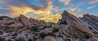
The Vasquez Formation (Tvz) is a geologic formation cropping out at the eponymous Vasquez Rocks in southern California. The formation dates to the Late Oligocene to Early Miocene.
References
- 1 2 3 4 5 Elephant Canyon of Cutler Group, USGS
- 1 2 3 4 Rock Sequence of the Canyonlands Area
- ↑ Doelling, H.H., Kuehne, P.A., Willis, G.C. and Ehler, J.B., 2015. Geologic map of the San Rafael Desert 30'x 60'quadrangle, Emery and Grand Counties, Utah. Utah Geological Survey. Map 267DM, https://ugspub.nr.utah.gov/publications/geologicmaps/30x60quadrangles/m-267.pdf
- Various Contributors to the Paleobiology Database. "Fossilworks: Gateway to the Paleobiology Database" . Retrieved 17 December 2021.
| | This article related to the Permian period is a stub. You can help Wikipedia by expanding it. |
| | This article about a specific stratigraphic formation in Utah is a stub. You can help Wikipedia by expanding it. |