
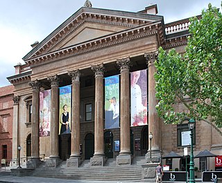
Bendigo is a city in Victoria, Australia, located in the Bendigo Valley near the geographical centre of the state and approximately 150 kilometres (93 mi) north-west of Melbourne, the state capital.
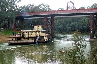
Echuca is a town on the banks of the Murray River and Campaspe River in Victoria, Australia. The border town of Moama is adjacent on the northern side of the Murray River in New South Wales. Echuca is the administrative centre and largest settlement in the Shire of Campaspe. As of the 2021 census, Echuca had a population of 15,056, and the population of the combined Echuca and Moama townships was 22,568.

Mooroopna is a town located 181 kilometres (112 mi) north of Melbourne, Victoria, Australia. It is on the banks of the Goulburn River opposite the larger town of Shepparton. The Midland Highway crosses the river between the two towns. At the 2016 census, Mooroopna had a population of 7,942.

Kyneton is a town in the Macedon Ranges region of West Central Victoria, Australia. The Calder Freeway bypasses Kyneton to the north and east. Kyneton is on Dja Dja Wurrung, Taungurung and Wurundjeri Woi Wurrung country.

Rochester is a town in rural Victoria, Australia. It is located 180 km (110 mi) north of Melbourne with a mixture of rural and semi-rural communities on the northern Campaspe River, between Bendigo and the Murray River port of Echuca. At the 2021 census, Rochester had a population of 3,154.

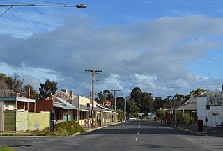
Avenel is a town in Victoria, Australia. It is in the Shire of Strathbogie local government area. At the 2016 census, Avenel had a population of 1,048, up from 728 at the 2006 census and 552 at the 2001 census.
North Central Victoria is a rural region in the Australian state of Victoria. The region lies to the south of the Victorian/New South Wales border as defined by the Murray River, to the southwest of the Hume region, to the west of the Great Dividing Range contained within the Central Highlands and Victorian Alps, to the north of Greater Melbourne, to the northeast of the Wimmera, and to the east of the Mallee region.

Kyabram is a town in north central Victoria, Australia. Kyabram is located in the centre of a rich irrigation district in the Goulburn River Valley, 200 kilometres (120 mi) north of Melbourne. It is the second-largest town in the Shire of Campaspe, situated between the towns of Echuca and Shepparton and is close to the Murray River, Goulburn River, Campaspe River and Waranga Basin. As of the 2016 census the town had a population of 7,331 people and provides services to a district population of around 16,000. Surrounding smaller towns include Merrigum, Lancaster, Undera, Cooma, Wyuna, Kyvalley, Girgarre, Stanhope and Tongala.

Axedale is a town in Victoria, Australia. It is located on the McIvor Highway, in the City of Greater Bendigo, east of Bendigo. It was surveyed and proclaimed in 1861. At the 2021 census, Axedale had a population of 984.

Henty is a town in southwestern New South Wales close to the boundaries of the South West Slopes and the Riverina districts, almost midway between the regional cities of Albury and Wagga Wagga. At the 2006 census, Henty had a population of 863 people.
The Australian Scout Jamboree is a jamboree which is held every three years by Scouts Australia. The Jamboree is traditionally held in early January and typically runs for ten nights.

Romsey is a town in the local government area of the Shire of Macedon Ranges in the state of Victoria, Australia. The town is 61 kilometres (38 mi) north of Melbourne. At the 2011 census, Romsey had a population of 4,412.

Moama is a town in the Riverina district of southern New South Wales, Australia, in the Murray River Council local government area. The town is directly across the Murray River from the larger town of Echuca in the neighbouring state of Victoria, to which it is connected by a bridge. At the 2016 census, Moama had a population of 5,620.

The County of Bendigo is one of the 37 counties of Victoria which are part of the cadastral divisions of Australia, used for land titles. It includes the city of Bendigo. It is bounded by the Campaspe River in the east, and the Loddon River in the west. The county was proclaimed in 1869.

Eaglehawk is a suburb within the City of Greater Bendigo and a former gold-mining town in Victoria, Australia.

Lockington is a town in northern Victoria, Australia in the Shire of Campaspe local government area, 198 kilometres north of the state capital, Melbourne. At the 2016 census, Lockington had a population of 808.

Toolleen is a town in northern Victoria, Australia. The town is on the Northern Highway and is in the Shire of Campaspe and the City of Greater Bendigo local government areas, 142 kilometres (88 mi) north of the state capital, Melbourne. At the 2016 census, Toolleen and the surrounding area had a population of 182.
Bealiba is a town in the Australian state of Victoria. The town is located in the Central Goldfields Shire local government area, 207 kilometres (129 mi) north-west of the state capital, Melbourne, and 74 kilometres (46 mi) from the regional city of Bendigo. At the 2011 census, Bealiba and the surrounding area had a population of 300.

The Campaspe River, an inland intermittent river of the north–central catchment, part of the Murray-Darling basin, is located in the lower Riverina bioregion and Central Highlands and Wimmera regions of the Australian state of Victoria. The headwaters of the Campaspe River rise on the northern slopes of the Great Dividing Range and descend to flow north into the Murray River, Australia's longest river, near Echuca.

Strathallan is a locality in the Goulburn Valley region of Victoria, Australia. The locality is in the Shire of Campaspe, and on the Campaspe River, 198 kilometres (123 mi) north of the state capital, Melbourne.

