
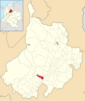
Santander is a department of Colombia. Santander inherited the name of one of the nine original states of the United States of Colombia. It is located in the central northern part of the country, borders the Magdalena River to the east, Boyacá to the south and southeast, the Norte de Santander Department to the northeast, the Cesar Department to the north, and the Bolivar and Antioquia Departments to the west. Its capital is the city of Bucaramanga.

Cúcuta, officially San José de Cúcuta, is a Colombian city, capital of Norte de Santander department. It is located in the northeast of the country, in the eastern branch of the Colombian Andes, on the border with Venezuela. Cúcuta has a population of 711,715 people according to the 2018 census, making it the 6th largest city in the country. Due to its proximity with Venezuela, Cúcuta is an important commercial center, hosting many billion dollar companies. The international border in Cúcuta is said to be the most dynamic of South America. The city has a length of 12 kilometres from north to south and 11 kilometres from east to west. It is divided into 10 communes and it is the political, economic, administrative, industrial, cultural and tourism hub of the Norte de Santander department.

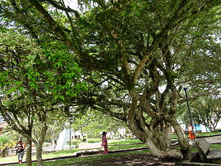
Bucaramanga is the capital and largest city of the department of Santander, Colombia. Bucaramanga has the fifth-largest economy by GDP in Colombia, has the highest GDP per capita in Colombia, has the lowest unemployment rate and has the ninth-largest population in the country, with 581,130 people. Bucaramanga has over 160 parks scattered throughout the city and has been given the nickname "La Ciudad de Los Parques" and "La Ciudad Bonita de Colombia".

The Industrial University of Santander, abbreviated in Spanish with the acronym UIS, is a public university, based in a coeducational, and research model. The university serves the Santander Department, being the main campus located in the city of Bucaramanga, Santander, Colombia. The university also has satellite campuses across the department in the cities of Barrancabermeja, Barbosa, Málaga, Piedecuesta, Socorro.

Villa del Rosario is a Colombian municipality and town located in the eastern part of North Santander department. It is part of the Metropolitan Area of Cúcuta. The municipality is bordered to the north by Venezuela and the municipality of Cúcuta, to the south by the municipalities of Ragonvalia and Chinácota, to the east by Venezuela and to the west by the municipality of Los Patios.

Real San Andrés is a professional Colombian football team based in San Andrés Island, that currently plays in the Categoría Primera B. They play their home games at the Erwin O'Neill stadium.
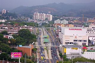
Floridablanca is a municipality in the department of Santander at an altitude of 925 metres (3,035 ft) in the Eastern Ranges of the Colombian Andes. It is part of the metropolitan area of the departmental capital Bucaramanga. Floridablanca is known for its parks and the Piedra del Sol, a large rock with spirals and circles carved by the Guane over 1,000 years ago. This city is home of the tallest statue of Jesus Christ in Colombia, "El Santisimo". The statue is 40 metres (130 ft) high and weighs 40 tonnes (88,000 lb). The city is situated along the Ruta Nacional 45A, a branch of the Pan American Highway, connecting the capital Bogotá with Santa Marta at the Caribbean coast and Cúcuta as a gateway to Venezuela. Together with other neighboring municipalities of Bucaramanga, Girón and Piedecuesta, Floridablanca is one of the growth areas for the capital of Santander with numerous constructions happening in recent years.
Encino is Spanish for oak. Encino may refer to:

Toledo is a Colombian municipality and town located in the department of North Santander. It is on the border with Boyacá Department and has natural gas development in the township of Gibraltar. In August 2011 the Gibraltar to Bucaramanga gas pipeline was completed.

Bolívar is a town and municipality in the Santander Department in northeastern Colombia.
Charalá is a town and municipality in the south of the department of Santander in northeastern Colombia. Its antipode is located within the capital of Indonesia, Jakarta.
El Guacamayo is a town and municipality in the Santander Department in northeastern Colombia.

Puente Nacional is a town and municipality in the Saravita Valley, part of the Santander Department of northeastern Colombia.

Sucre is a town and municipality in the Santander Department in northeastern Colombia.

Vetas is a town and municipality in the Santander Department in northeastern Colombia.
Ramiro Suárez Corzo is a Colombian politician. Former Mayor of the Colombian city of Cúcuta, Norte de Santander and actually is a convicted Murderer.

Cerinza is a town and municipality in the Colombian Department of Boyacá, and part of the Tundama Province subregion. Cerinza borders Belén in the north, Encino, Santander in the west, Santa Rosa de Viterbo in the south and Floresta and Betéitiva in the east.

North Santander is a department of Colombia. It is in the north of the country, bordering Venezuela. Its capital is Cúcuta, one of the country's major cities.

Yariguíes Airport is an airport serving Barrancabermeja, a city in the Santander Department of Colombia. The airport is 6 kilometres (3.7 mi) southeast of the city.

The Chicamocha Canyon is a steep sided canyon carved by the Chicamocha River in Colombia. With a maximum depth of 2,000 metres (6,600 ft), an area of 108,000 hectares and a length of 227 kilometres (141 mi), the canyon is the second-largest worldwide. The canyon is situated in the departments of Boyacá and Santander, stretching from Soatá in the southeast to Girón and Betulia in the northwest.


