
The Missouri River is the longest river in the United States. Rising in the eastern Centennial Mountains of the Bitterroot Range of the Rocky Mountains of southwestern Montana, the Missouri flows east and south for 2,341 miles (3,767 km) before entering the Mississippi River north of St. Louis, Missouri. The river drains semi-arid watershed of more than 500,000 square miles (1,300,000 km2), which includes parts of ten U.S. states and two Canadian provinces. Although a tributary of the Mississippi, the Missouri River is slightly longer and carries a comparable volume of water. When combined with the lower Mississippi River, it forms the world's fourth-longest river system.
Platte County is a county located in the northwestern portion of the U.S. state of Missouri and is part of the Kansas City metropolitan area. As of the 2020 census, the population was 106,718. Its county seat is Platte City. The county was organized December 31, 1838, from the Platte Purchase, named for the Platte River. The Kansas City International Airport is located in the county, approximately one mile west of Interstate 29 between mile markers 12 and 15. The land for the airport was originally in an unincorporated portion of Platte County before being annexed by Platte City, and eventually Kansas City.

Parkville is a city in Platte County, Missouri, United States and is a part of the Kansas City Metropolitan Area. The population was 7,177 at the 2020 census, According to 2022 census estimates, the city is estimated to have a population of 8,541. Parkville is known for its antique shops, art galleries, and historic downtown. The city is home to Park University, English Landing Park, Platte Landing Park, and the National Golf Club of Kansas City. Large neighborhoods in Parkville include: Riss Lake, The National, Thousand Oaks, Creekside, Parkville Heights, River Hills, Riverchase, The Bluffs, Downtown, and Pinecrest.

Manhattan is a city in and the county seat of Riley County, Kansas, U.S., although the city extends into Pottawatomie County. It is located in northeastern Kansas at the junction of the Kansas River and Big Blue River. As of the 2020 Census, the population of the city was 54,100.
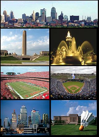
The Kansas City metropolitan area is a bi-state metropolitan area anchored by Kansas City, Missouri. Its 14 counties straddle the border between the U.S. states of Missouri and Kansas. With 8,472 square miles (21,940 km2) and a population of more than 2.2 million people, it is the second-largest metropolitan area centered in Missouri and is the largest metropolitan area in Kansas, though Wichita is the largest metropolitan area centered in Kansas. Alongside Kansas City, Missouri, these are the suburbs with populations above 100,000: Overland Park, Kansas; Kansas City, Kansas; Olathe, Kansas; Independence, Missouri; and Lee's Summit, Missouri.
The Great Flood of 1993 was a flood that occurred in the Midwestern United States, along the Mississippi and Missouri rivers and their tributaries, from April to October 1993.

In mid-July 1951, heavy rains led to a great rise of water in the Kansas River, Missouri River, and other surrounding areas of the Central United States. Flooding occurred in the Kansas, Neosho, Marais Des Cygnes, and Verdigris river basins. The damage in June and July 1951 across eastern Kansas and Missouri exceeded $935 million. The flooding killed 17 people and displaced 518,000.

Tuttle Creek Lake is a reservoir on the Big Blue River 5 miles (8 km) north of Manhattan, in the Flint Hills region of northeast Kansas. It was built and is operated by the Army Corps of Engineers for the primary purpose of flood control. Secondary functions of the project include release of water stores to maintain barge traffic on the Mississippi River during seasons of drought, maintenance of a multi-use conservation pool for fish and wildlife enhancement and recreation, and release of sufficient water in droughts to maintain water quality for downstream communities.

The Anchor Line was a steamboat company that operated a fleet of boats on the Mississippi River between St. Louis, Missouri, and New Orleans, Louisiana, between 1859 and 1898, when it went out of business. It was one of the most well-known, if not successful, pools of steamboats formed on the lower Mississippi River in the decades following the American Civil War.
The Great Flood of 1844 is the biggest flood ever recorded on the Missouri River and Upper Mississippi River in North America in terms of discharge. The adjusted economic impact was not as great as subsequent floods because of the small population in the region at the time. The flood devastation was particularly widespread since the region had few levees at the time, so the waters were able to spread far from the normal banks. Among the hardest hit in terms of mortality were the Wyandot Indians, who lost 100 people in the diseases that occurred after the flood in the vicinity of today's Kansas City, Kansas.
The Park Hill School District encompasses most of southern Platte County, Missouri, in the Northland region of the Kansas City Metropolitan Area. There are eight cities and towns that are partly or entirely within the district boundaries, including Parkville, Riverside, Weatherby Lake, Platte Woods, Lake Waukomis, Houston Lake, Northmoor and Kansas City, Missouri. The district serves almost 12,000 students and has about 73 square miles of area.
George Shepherd Park was a Texas War of Independence hero and founder of Parkville, Missouri, Park University, and Manhattan, Kansas. He helped establish Kansas State University.

The geography of Omaha, Nebraska is characterized by its riverfront position alongside the Missouri River. The city's geography, with its proximity to the river was a factor in making Omaha the "Gateway of the West" from which thousands of settlers traveled into the American West during the 19th century. Environmental issues include more than one hundred years of industrial smelting along the riverfront along with the continuous impact of suburban sprawl on the city's west side. The city's climate is temperate.
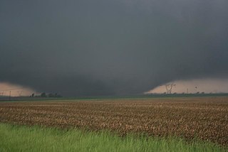
The tornado outbreak sequence of June 3–11, 2008 was a series of tornado outbreaks affecting most of central and eastern North America from June 3–11, 2008. 192 tornadoes were confirmed, along with widespread straight–line wind wind damage. Seven people were killed from a direct result of tornadoes; four in Iowa, two in Kansas, and one in Indiana. Eleven additional people were killed across five states by other weather events including lightning, flash flooding, and straight-line winds. Severe flooding was also reported in much of Indiana, Wisconsin, Minnesota and Iowa as a result of the same thunderstorms, while high heat and humidity affected much of eastern North America; particularly along the eastern seaboard of the United States from New York City to the Carolinas.

From May 3 to May 11, 2003, a prolonged and destructive series of tornado outbreaks affected much of the Great Plains and Eastern United States. Most of the severe activity was concentrated between May 4 and May 10, which saw more tornadoes than any other week-long span in recorded history; 335 tornadoes occurred during this period, concentrated in the Ozarks and central Mississippi River Valley. Additional tornadoes were produced by the same storm systems from May 3 to May 11, producing 363 tornadoes overall, of which 62 were significant. Six of the tornadoes were rated F4, and of these four occurred on May 4, the most prolific day of the tornado outbreak sequence; these were the outbreak's strongest tornadoes. Damage caused by the severe weather and associated flooding amounted to US$4.1 billion, making it the costliest U.S. tornado outbreak of the 2000s. A total of 50 deaths and 713 injuries were caused by the severe weather, with a majority caused by tornadoes; the deadliest tornado was an F4 that struck Madison and Henderson counties in Tennessee, killing 11.

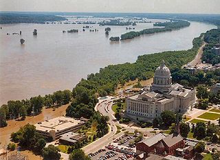
The 2011 flooding event on the Missouri River in the United States was triggered by record snowfall in Rocky Mountains of Montana and Wyoming along with near-record spring rainfall in central and eastern Montana. All six major dams along the Missouri River released record amounts of water to prevent overflow which led to flooding threatening several towns and cities along the river from Montana to Missouri; in particular Bismarck, North Dakota; Pierre, South Dakota; Dakota Dunes, South Dakota; South Sioux City, Nebraska, Sioux City, Iowa; Omaha, Nebraska; Council Bluffs, Iowa; Saint Joseph, Missouri; Kansas City, Missouri; Jefferson City, Missouri, and St. Louis, Missouri. Many smaller towns were also at risk, suffering the same fate as the larger cities if not worse. According to the National Weather Service, in the second half of the month of May 2011, almost a year's worth of rain fell over the upper Missouri River basin. Extremely heavy rainfall in conjunction with an estimated 212 percent of normal snowpack in the Rocky Mountains contributed to this flooding event.

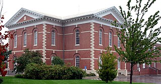
The Waddell "A" Truss Bridge, also known by its original name of Linn Branch Creek Bridge is one of two surviving examples of the "A" Truss Bridge type originated by John Alexander Low Waddell. It was originally completed in 1898 near Trimble, Missouri, and is currently located at English Landing Park in Parkville, Platte County, Missouri. The bridge was relocated in 1987 and listed on the National Register of Historic Places in 1991.

The March 2019 North American blizzard was a powerful Colorado Low that produced up to two feet of snow in the plains and Midwest. Rapid snowmelt following the storm caused historic flooding, and some areas received hurricane-force wind gusts. Comparable to the 1993 Storm of the Century, the storm was labeled a bomb cyclone after barometric pressure readings dropped in excess of 24 mbar (0.71 inHg) over a 24-hour period. After the storm entered Colorado from its origination in Arizona, the pressure dropped more than 30 mbar (0.89 inHg) and rapidly intensified over the western High Plains. The severe storm set new all-time record low barometric pressure readings in Colorado, Kansas and New Mexico. The storm itself killed only one person in Colorado, but flooding caused by the storm killed at least 3, one in Iowa and at least two in Nebraska and left ~140,000 without power in Texas.

The tornado outbreak sequence of May 2019 was a prolonged series of destructive tornadoes and tornado outbreaks affecting the United States over the course of nearly two weeks, producing a total of 402 tornadoes, including 53 significant events (EF2+). Eighteen of these were EF3 tornadoes, spanning over multiple states, including Nebraska, Kansas, Texas, Missouri, Oklahoma, Indiana, Iowa, and Ohio, with additional tornadoes confirmed across a region extending from California to New Jersey. Two EF4 tornadoes occurred, one in Dayton, Ohio, and the other in Linwood, Kansas. Four tornadoes during this outbreak were fatal, causing a total of eight fatalities. The deadliest of these occurred on May 22 near Golden City, Missouri, where an EF3 tornado took three lives, including an elderly couple in their eighties. The damaging series of tornadoes that occurred in Indiana and Ohio on the evening of May 27 during this event is sometimes locally referred to as the Memorial Day tornado outbreak of 2019, which became the 4th costliest weather event in Ohio history. The near continuous stream of systems also produced to widespread flash and river flooding, along with damaging winds and large hail.

A deadly and destructive outbreak sequence of 23 tornadoes struck parts of the Great Plains and the Great Lakes in late-June 1957. At least seven significant tornadoes (F2+) touched down during the outbreak sequence. The most devastating storm was a large, violent, and catastrophic 500-yard-wide F5 tornado family that struck Fargo, North Dakota on Thursday, June 20, 1957, killing 10 people and becoming the deadliest tornado ever recorded in North Dakota. The outbreak caused 11 fatalities, 105 injuries, and $25.883 million in damage.

