This article has multiple issues. Please help improve it or discuss these issues on the talk page . (Learn how and when to remove these template messages)
|
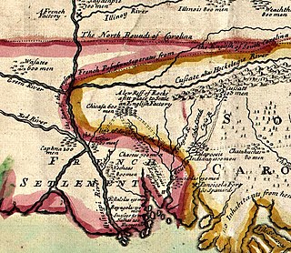
English Turn is a bend in the Mississippi River in New Orleans, Louisiana.
This article has multiple issues. Please help improve it or discuss these issues on the talk page . (Learn how and when to remove these template messages)
|
English Turn is a bend in the Mississippi River in New Orleans, Louisiana.
In 1699, French explorers Sauvolle and Jean-Baptiste Le Moyne de Bienville were exploring the lower Mississippi and encountered English ships. Bienville was successful in ordering the English out of the river, and the event left the name, English Turn, on the bend. [1] [2] [3]

France began colonizing the Americas in the 16th century and continued into the following centuries as it established a colonial empire in the Western Hemisphere. France established colonies in much of eastern North America, on several Caribbean islands, and in South America. Most colonies were developed to export products such as fish, rice, sugar, and furs.
New Sarpy is a census-designated place (CDP) in St. Charles Parish, Louisiana, United States. The population was 1,169 at the 2020 census.
Pierre Le Moyne d'Iberville or Sieur d'Iberville was a French soldier, explorer, colonial administrator, and trader. He is noted for founding the colony of Louisiana in New France. He was born in Montreal to French colonist parents.

Events from the year 1706 in Canada.

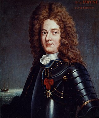
Jean-Baptiste Le Moyne de Bienville, also known as Sieur de Bienville, was a French colonial administrator in New France. Born in Montreal, he was an early governor of French Louisiana, appointed four separate times during 1701–1743. He was the younger brother of explorer Pierre Le Moyne d'Iberville.
Pierre Dugué de Boisbriand was a French Canadian soldier, politician, and aristocrat who commanded several areas in North America colonized by New France in the early 18th Century and who served as the seventh governor of the French colony of Louisiana.
Bienville may refer to:
The Chickasaw Wars were fought in the first half of the 18th century between the Chickasaw allied with the British against the French and their allies the Choctaws and Illinois Confederation. The Province of Louisiana extended from Illinois to New Orleans, and the French fought to secure their communications along the Mississippi River. The Chickasaw, dwelling in northern Mississippi and western Tennessee, lay across the French path. Much to the eventual advantage of the British and the later United States, the Chickasaw successfully held their ground. The wars came to an end only with the French cession of New France to the British in 1763 according to terms of the Treaty of Paris.

Fort Charlotte, Mobile is a partially-reconstructed 18th-century fort in Mobile, Alabama.

Fort Tombecbe, also spelled Tombecbee and Tombeché, was a stockade fort located on the Tombigbee River near the border of French Louisiana, in what is now Sumter County, Alabama. It was constructed under the leadership of Jean-Baptiste Le Moyne, Sieur de Bienville in 1736–1737 as trading post about 270 miles (430 km) upriver from Mobile, on an 80-foot (24 m) limestone bluff. Fort Tombecbe was built in Choctaw lands and would play a major role in colonial France's efforts to stop British intrusions into the area. Bienville claimed that the new fort was to protect the Choctaw from the Chickasaw. In May of 1736, Bienville, along with a force of 600 soldiers combined with a force of 600 Choctaw warriors, set out from Fort Tombecbe and attacked the Chickasaw near present-day Tupelo, Mississippi at the Battle of Ackia. Tombecbe was a major French outpost and trade depot among the Choctaw, the largest Native American group in the colony.

Fort Maurepas, later known as Old Biloxi, was developed in colonial French Louisiana in April 1699 along the Gulf of Mexico . Fort Maurepas was designated temporarily as the capital of Louisiana in 1699. The capital was moved from Biloxi to Mobile in 1710, then to New Orleans in 1723 on the Mississippi River. Government buildings in the latter city were still under construction.
Fort De La Boulaye Site, also known as Fort Mississippi, is the site of a fort built by the French in south Louisiana in 1699–1700, to support their claim of the Mississippi River and valley. Native Americans forced the French to vacate the fort by 1707.
Jean-François-Benjamin Dumont de Montigny, or Dumont de Montigny, was a French colonial officer and farmer in French Louisiana in the 18th century. He was born in Paris, France, on July 31, 1696, and died in 1760 in Pondicherry, India. His writings about French Louisiana include a two-volume history published in 1753, as well as an epic poem and a prose memoir preserved in manuscript and published long after his death.
The Natchez revolt, or the Natchez massacre, was an attack by the Natchez Native American people on French colonists near present-day Natchez, Mississippi, on November 29, 1729. The Natchez and French had lived alongside each other in the Louisiana colony for more than a decade prior to the incident, mostly conducting peaceful trade and occasionally intermarrying. After a period of deteriorating relations and warring, Natchez leaders were provoked to revolt when the French colonial commandant, Sieur de Chépart, demanded land from a Natchez village for his own plantation near Fort Rosalie. The Natchez plotted their attack over several days and managed to conceal their plans from most of the French; colonists who overheard and warned Chépart of an attack were considered untruthful and were punished. In a coordinated attack on the fort and the homesteads, the Natchez killed almost all of the Frenchmen, while sparing most of the women and enslaved Africans. Approximately 230 colonists were killed overall, and the fort and homes were burned to the ground.

Adrien de Pauger was the French engineer and cartographer who designed the streets of the Vieux Carre, today known as the "French Quarter", and drew the original map of the city that became New Orleans, Louisiana. De Pauger was appointed in 1720 by Jean-Baptiste Le Moyne de Bienville to draw up the plans for the new city. De Pauger arrived in the settlement on March 29, 1721. The plan was completed later in 1721, which was a significant step to establishing permanence in the French settlement. De Pauger also selected many of the street names such as Bourbon Street and Royal Street as well as others. This street plan is still in place today. Working with Bienville's chief engineer Pierre Le Blond de La Tour, they impressed slave labor to construct the settlement making use of water-resistant cypress wood for raised cottage construction. Slaves under de Pauger labored under the rules of Code Noir, which defined the conditions of slaves in the French Colonial Empire.

Oysters Bienville is a traditional dish in New Orleans cuisine of baked oysters in a shrimp sauce. It is served at some of the city's renowned restaurants, originating at Arnaud's. Ingredients include shrimp, mushrooms, bell peppers, sherry, a roux with butter, Parmesan cheese and other lighter cheese, and bread crumbs. The oysters are baked in the shell or can be made in a small casserole dish or au gratin dish. The dish was named for Jean-Baptiste Le Moyne de Bienville (1680–1767), French governor of Louisiana and founder of New Orleans.
Events from the year 1698 in France.
Pierre le Blond de la Tour (1673–1723/4) was an engineer in French Louisiana who was largely responsible for the layout of early New Orleans. He is credited with performing the first work to improve navigability on an American inland river, and also the first work on constructing levees on the Lower Mississippi River.
Albert Rieker (1889–1959) was a German-born American sculptor. He designed public sculptures in Louisiana and Mississippi.
Antoine Le Moyne de Châteauguay was a French soldier and colonial administrator who assisted in the foundation of the French colony of Louisiana in 1699–1702. He served in various posts in Mobile, Louisiana and Martinique. He was governor of Cayenne from 1738 to 1743, then governor of Île Royale from 1745.