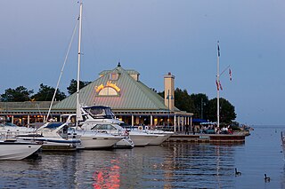
Mississauga, historically known as Toronto Township, is a Canadian city in the province of Ontario, situated on the western shore of Lake Ontario in the Regional Municipality of Peel, adjoining the western border of Toronto. With a population of 717,961 as of 2021, Mississauga is the seventh-most populous municipality in Canada, third-most in Ontario, and second-most in the Greater Toronto Area (GTA) after Toronto itself. However, for the first time in its history, the city's population declined according to the 2021 census, from a 2016 population of 721,599 to 717,961, a 0.5 per cent decrease.

Scarborough Centre is a bus terminal in Toronto, Ontario, Canada, serving multiple bus routes of the Toronto Transit Commission (TTC) and one Durham Regional Transit (DRT) bus route. It was also a rapid transit station serving Line 3 Scarborough of the Toronto subway system until Line 3's closure on July 24, 2023. It is located north of Ellesmere Road between Brimley and McCowan Roads, just south of Highway 401. It was adjacent to the former Scarborough Centre Bus Terminal, which was a station for GO Transit buses and other intercity coach services until the TTC modified the facility for TTC buses.

MiWay, also known as Mississauga Transit and originally as Mississauga Transit Systems, is the municipal public transport agency serving Mississauga, Ontario, Canada, and is responsible to the city's Transportation and Works Department. MiWay services consist of two types of bus routes: MiLocal, local buses that make frequent stops, and MiExpress, express buses between major destinations. MiWay is the primary operator along the Mississauga Transitway, a dedicated east–west bus-only roadway.
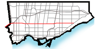
Eglinton Avenue is a major east–west arterial thoroughfare in Toronto and Mississauga in the Canadian province of Ontario. The street begins at Highway 407 at the western limits of Mississauga, as a continuation of Lower Baseline in Milton. It traverses the midsection of both cities and ends at Kingston Road. Eglinton Avenue is the only street to cross all six former cities and boroughs of Metropolitan Toronto.

Credit Valley Hospital is a regional hospital located in Mississauga, Ontario. Officially opened on November 5, 1985, it is now part of the Trillium Health Partners hospital group and primarily serves the communities of north Mississauga: Streetsville, Meadowvale, Erin Mills and the surrounding area. In 2012, it was ranked as the best hospital in the Greater Toronto Area in a study conducted by the Canadian Institute for Health Information.

The Mississauga Transitway is a bus rapid transit (BRT) system in Mississauga, Ontario, Canada. It comprises a series of purpose-constructed bus-only roadways, as well as reserved lanes on existing city streets and portions of Highway 403, that together form a continuous 18 km (11 mi) route spanning most of the city from Winston Churchill Boulevard in the west to the junction of Highways 401 and 427 in the east on the border with Toronto. Service on the Transitway is provided by MiWay and GO Transit, with some stations providing connections to Brampton Transit and Toronto Transit Commission (TTC) bus services.

Transit City was a plan for developing public transport in Toronto, Ontario, Canada. It was first proposed and announced on 16 March 2007 by Toronto mayor David Miller and Toronto Transit Commission (TTC) chair Adam Giambrone. The plan called for the construction of seven new light rail lines along the streets of seven priority transit corridors, which would have eventually been integrated with existing rapid transit, streetcar, and bus routes. Other transit improvements outlined in the plan included upgrading and extending the Scarborough RT line, implementing new bus rapid transit lines, and improving frequency and timing of 21 key bus routes. The plan integrated public transportation objectives outlined in the City of Toronto Official Plan, the TTC Ridership Growth Strategy and Miller's 2006 election platform.

The Hurontario LRT is a light rail line under construction in the cities of Mississauga and Brampton, Ontario, Canada. The line will run along Hurontario Street from Mississauga's Port Credit neighbourhood north to Steeles Avenue in Brampton. The line will be built and operated as a public-private partnership by Mobilinx, a consortium of private European and Japanese companies, with provincial transit agency Metrolinx retaining ownership of the line. It will be the only street railway operating in the Greater Toronto Area outside Toronto proper.

The Meadowvale Town Centre Bus Terminal is the main, inter-regional transit hub for the community of Meadowvale located in northwestern Mississauga, Ontario, Canada. It is the third-largest terminal served by MiWay, the second-largest in Mississauga after City Centre Transit Terminal. It is situated on the eastern side of Meadowvale Town Centre, which is a community mall.

The South Common Centre Bus Terminal is located in western Mississauga, Ontario, Canada. It is situated on the western side of South Common Centre.

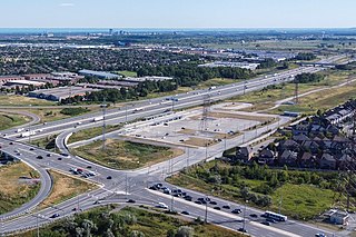
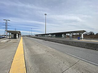
Renforth, referred to during planning as Renforth Gateway, is a bus station on the border of the cities of Mississauga and Toronto, in Ontario, Canada. Located at Eglinton Avenue and Renforth Drive, it is the eastern terminus of the Mississauga Transitway and is close to the interchange between Highway 401 and Highway 427.
Winston Churchill is a bus station in the community of Erin Mills in western Mississauga, Ontario, Canada. It is located northwest of the Winston Churchill Boulevard / Highway 403 interchange and is the western terminus of the Mississauga Transitway.
Erin Mills is a bus station in the community of Erin Mills in western Mississauga, Ontario, Canada. It is located northwest of the Erin Mills Parkway/Highway 403 interchange and is a stop on the Mississauga Transitway.

502 Züm Main is a bus rapid transit route in Brampton, Ontario which leads south into Mississauga, Ontario. The second corridor, which began service on September 6, 2011, runs from Sandalwood Parkway in the city's north end to MiWay's City Centre Transit Terminal near the Square One Shopping Centre in the south. It travels via the Downtown Brampton and Brampton Gateway terminals along Main and Hurontario Streets through Brampton and Mississauga. It covers the route of current route 2, which has frequent rush-hour service. Route 502 extends and replace MiWay's route 102 InterCity Express. It runs every 10 minutes during rush hours and 20 minutes off-peak hours, including weekends. Route 2's rush hour frequency was reduced to 20 minutes to optimize ridership.

The Highway 7 Rapidway in York Region, Ontario, Canada, is a bus rapid transit right-of-way that runs from Bruce Street in Vaughan to Birchmount Road in Markham. There are plans to extend it west to Highway 50 and east to Cornell Terminal. It is served by Viva Purple, Viva Pink, and Viva Orange bus routes.

Burnhamthorpe Road is a major arterial road in the cities of Toronto and Mississauga, Ontario; beginning at Dundas Street, near Islington Avenue, running west and becoming a rural road in the Town of Oakville, where it terminates at Tremaine Road, where it changes name.
The Big Move is a regional transportation plan (RTP) published in 2008 and consisting of 62 rapid transit projects to be implemented across the Greater Toronto and Hamilton Area (GTHA). These rapid transit projects are intended to form a seamlessly integrated regional rapid transit network, which is the first priority action in the regional transportation plan. These projects form two long-term templates with 15 and 25 year horizons. These templates outline broad projects; specific details about technology, alignment, stations and service levels for each project are subsequently determined though a cost–benefit analysis or an environmental assessment process.

The transport infrastructure and services in the Canadian city of Mississauga, Ontario include provincial highways and municipal roads, passenger and freight rail, regional and municipal bus service, and an international airport. It is interconnected with air, road, and rail transportation networks spanning the Greater Toronto Area and beyond.
The Pearson Regional Transit Centre also known as Union Station West is a proposed second intermodal transportation hub to serve the Greater Toronto Area. The transit hub will be located at the site of Viscount station currently serving the Link Train across from Toronto Pearson International Airport in Mississauga, Ontario. The transit hub will be accommodated with a new passenger and processing facility known as Terminal New. It will handle functions such as check-in, security screenings and baggage claim. The transit hub will also be at the centre of a new mixed-used area including office, retail and commercial space. The plan is to bring Line 5 Eglinton, Line 6 Finch West, the Mississauga Transitway, the Kitchener line and the Union Pearson Express together into the transit hub and it will relieve Union Station. The transit centre is planned to open in the early 2030s.