Erwin, South Dakota

Last updated

Erwin, South Dakota
Kingsbury County South Dakota Incorporated and Unincorporated areas Erwin Highlighted.svg
Location in Kingsbury County and the state of South Dakota
Coordinates: 44°29′17″N97°26′27″W / 44.48806°N 97.44083°W / 44.48806; -97.44083
Country United States
State South Dakota
County Kingsbury
Platted1887 [1]
Area
[2]
  Total0.48 sq mi (1.23 km2)
  Land0.48 sq mi (1.23 km2)
  Water0.00 sq mi (0.00 km2)
Elevation
[3]
1,860 ft (570 m)
Population
 (2020) [4]
  Total40
  Density84.03/sq mi (32.44/km2)
Time zone UTC-6 (Central (CST))
  Summer (DST) UTC-5 (CDT)
ZIP code
57233
Area code 605
FIPS code 46-19860 [5]
GNIS feature ID1267381 [3]

Erwin is a town in Kingsbury County, South Dakota, United States. The population was 45 at the 2010 census.

Contents

History

A post office has been in operation at Erwin since 1882. [6] The town site was platted in 1887. [7] James Erwin Hollister, an early postmaster, gave the town his name. [7]

Geography

According to the United States Census Bureau, the town has a total area of 0.48 square miles (1.24 km2), all land. [8]

Demographics

Historical population
CensusPop.Note
1900 131
1910 23075.6%
1920 25711.7%
1930 205−20.2%
1940 182−11.2%
1950 153−15.9%
1960 1572.6%
1970 106−32.5%
1980 66−37.7%
1990 42−36.4%
2000 5838.1%
2010 45−22.4%
2020 40−11.1%
U.S. Decennial Census [9] [4]

2010 census

As of the census [10] of 2010, there were 45 people, 22 households, and 15 families residing in the town. The population density was 93.8 inhabitants per square mile (36.2/km2). There were 29 housing units at an average density of 60.4 per square mile (23.3/km2). The racial makeup of the town was 97.8% White and 2.2% from two or more races. Hispanic or Latino of any race were 6.7% of the population.

There were 22 households, of which 13.6% had children under the age of 18 living with them, 54.5% were married couples living together, 9.1% had a female householder with no husband present, 4.5% had a male householder with no wife present, and 31.8% were non-families. 31.8% of all households were made up of individuals, and 13.6% had someone living alone who was 65 years of age or older. The average household size was 2.05 and the average family size was 2.53.

The median age in the town was 59.5 years. 22.2% of residents were under the age of 18; 2.1% were between the ages of 18 and 24; 6.6% were from 25 to 44; 28.9% were from 45 to 64; and 40% were 65 years of age or older. The gender makeup of the town was 51.1% male and 48.9% female.

2000 census

As of the census [5] of 2000, there were 58 people, 26 households, and 17 families residing in the town. The population density was 123.1 inhabitants per square mile (47.5/km2). There were 34 housing units at an average density of 72.2 per square mile (27.9/km2). The racial makeup of the town was 100.00% White.

There were 26 households, out of which 19.2% had children under the age of 18 living with them, 65.4% were married couples living together, 3.8% had a female householder with no husband present, and 30.8% were non-families. 26.9% of all households were made up of individuals, and 23.1% had someone living alone who was 65 years of age or older. The average household size was 2.23 and the average family size was 2.72.

In the town, the population was spread out, with 22.4% under the age of 18, 1.7% from 18 to 24, 12.1% from 25 to 44, 34.5% from 45 to 64, and 29.3% who were 65 years of age or older. The median age was 52 years. For every 100 females, there were 81.3 males. For every 100 females age 18 and over, there were 87.5 males.

The median income for a household in the town was $33,125, and the median income for a family was $33,125. Males had a median income of $18,750 versus $16,875 for females. The per capita income for the town was $15,661. None of the population or families were below the poverty line.

Related Research Articles

<span class="mw-page-title-main">Sebec, Maine</span> Town in the state of Maine, United States

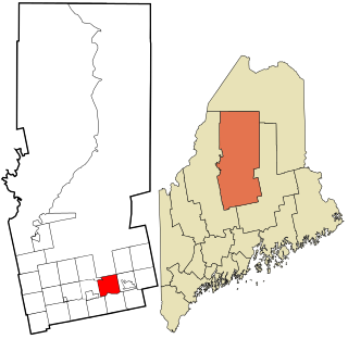
Sebec is a town in Piscataquis County, Maine, United States. The population was 665 at the 2020 census.

Alexander is a town in Washington County, Maine, United States. The population was 525 at the 2020 census. The town is named for Alexander Baring, 1st Baron Ashburton, the British negotiator of the Webster–Ashburton Treaty which ended the Aroostook War in 1838–1839.

<span class="mw-page-title-main">Knox, North Dakota</span> City in North Dakota, United States

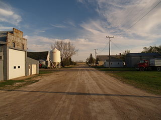
Knox is a city in Benson County, North Dakota, United States. The population was 22 at the 2020 census. Knox was founded in 1887.

<span class="mw-page-title-main">Palermo, North Dakota</span> City in Mountrail County, North Dakota, United States

Palermo is a city in Mountrail County, North Dakota, United States. The population was 125 at the 2020 census.

<span class="mw-page-title-main">Aneta, North Dakota</span> City in North Dakota, United States

Aneta is a city in Nelson County, North Dakota, United States. The population was 234 at the 2020 census. Aneta was first settled in 1882 and incorporated as a city in 1893.

<span class="mw-page-title-main">Forest River, North Dakota</span> City in North Dakota, United States

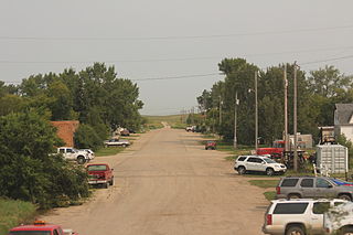
Forest River is a city in Walsh County, North Dakota, United States. The population was 109 at the 2020 census. Forest River was founded on July 13, 1887.

<span class="mw-page-title-main">Epping, North Dakota</span> City in North Dakota, United States

Epping is a city in Williams County, North Dakota, United States. The population was 84 at the 2020 census.

<span class="mw-page-title-main">Moscow, Ohio</span> Village in Ohio, United States

Moscow is a village in Clermont County, Ohio. The population was 155 at the time of the 2020 census. The William H. Zimmer Power Station, a coal-fired power plant that was converted from a planned nuclear power plant during construction, is partially located within village limits. It is located near the Ulysses S. Grant Birthplace.

<span class="mw-page-title-main">Tribbey, Oklahoma</span> Town in Oklahoma, United States

Tribbey is a town in Pottawatomie County, Oklahoma, United States.The community was named for Alpheus M. Tribbey, landowner. The population was 337 by the 2020 United States census.

<span class="mw-page-title-main">Franklin Township, Susquehanna County, Pennsylvania</span> Township in Pennsylvania, United States

Franklin Township is a township in Susquehanna County, Pennsylvania, United States. The population was 833 at the 2020 census. Salt Springs State Park, a Pennsylvania state park, is in Franklin Township.

<span class="mw-page-title-main">Florence, South Dakota</span> Town in South Dakota, United States

Florence is a town in northwestern Codington County, South Dakota, United States. It is part of the Watertown, South Dakota Micropolitan Statistical Area. The population was 337 at the 2020 census.

<span class="mw-page-title-main">Fairburn, South Dakota</span> Town in South Dakota, United States

Fairburn is a town in Custer County, South Dakota, United States. The population was 60 at the 2020 census.

<span class="mw-page-title-main">Ramona, South Dakota</span> Town in South Dakota, United States

Ramona is a town in Lake County, South Dakota, United States. The population was 159 at the 2020 census.

<span class="mw-page-title-main">Leola, South Dakota</span> City in South Dakota, United States

Leola is a small city in, and the county seat of, McPherson County, South Dakota, United States. It was founded on May 1, 1884, and named for Leola Haynes, daughter of one of the town's founders. The population was 434 as of the 2020 census.

<span class="mw-page-title-main">Crooks, South Dakota</span> City in South Dakota, United States

Crooks is a city in Minnehaha County, South Dakota, United States and is a suburb of Sioux Falls. The population was 1,362 at the 2020 census. Crooks was named New Hope until 1904. The town's present name honors W. A. Crooks, a local politician.

<span class="mw-page-title-main">Mabscott, West Virginia</span> Town in West Virginia, United States

Mabscott is a town in Raleigh County, West Virginia, United States. The population was 1,333 at the 2020 census. The town's name is a contraction of the name Mabel Scott, wife of local coal operator Cyrus H. Scott.

<span class="mw-page-title-main">Montrose, West Virginia</span> Town in West Virginia, United States

Montrose is a town in Randolph County, West Virginia, United States. The population was 141 at the 2020 census.

<span class="mw-page-title-main">North Hills, West Virginia</span> Town in West Virginia, United States

North Hills is a town in Wood County, West Virginia, United States. It is a suburb of Parkersburg. The population was 837 at the 2020 census. North Hills was incorporated on February 15, 1979.

<span class="mw-page-title-main">Kingston, Juneau County, Wisconsin</span> Town in Wisconsin, United States

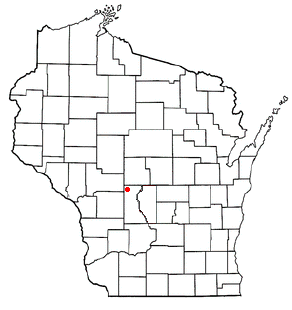
Kingston is a town in Juneau County, Wisconsin, United States. Its population was 58 at the 2000 census. The unincorporated communities of Mather and Meadow Valley are located in the town.

<span class="mw-page-title-main">Casey, Wisconsin</span> Town in Wisconsin, United States

Casey is a town in Washburn County, Wisconsin, United States. The population was 466 at the 2000 census.

References

  1. "SD Towns" (PDF). South Dakota State Historical Society. Archived from the original (PDF) on February 10, 2010. Retrieved February 11, 2010.
  2. "ArcGIS REST Services Directory". United States Census Bureau. Retrieved October 15, 2022.
  3. 1 2 U.S. Geological Survey Geographic Names Information System: Erwin, South Dakota
  4. 1 2 "Census Population API". United States Census Bureau. Retrieved October 15, 2022.
  5. 1 2 "U.S. Census website". United States Census Bureau . Retrieved January 31, 2008.
  6. "Kingsbury County". Jim Forte Postal History. Retrieved January 29, 2015.
  7. 1 2 Federal Writers' Project (1940). South Dakota place-names, v.1-3. University of South Dakota. p. 37.
  8. "US Gazetteer files 2010". United States Census Bureau. Archived from the original on January 25, 2012. Retrieved June 21, 2012.
  9. "Census of Population and Housing". Census.gov. Retrieved June 4, 2015.
  10. "U.S. Census website". United States Census Bureau . Retrieved June 21, 2012.