Essex, Missouri

Last updated

Essex, Missouri
Essex-water-tower-mo.jpg
Water tower
Stoddard County Missouri Incorporated and Unincorporated areas Essex Highlighted.svg
Location of Essex, Missouri
Coordinates: 36°48′43″N89°51′45″W / 36.81194°N 89.86250°W / 36.81194; -89.86250
Country United States
State Missouri
County Stoddard
Area
[1]
  Total0.29 sq mi (0.75 km2)
  Land0.29 sq mi (0.75 km2)
  Water0.00 sq mi (0.00 km2)
Elevation
[2]
299 ft (91 m)
Population
 (2020)
  Total403
  Density1,394.46/sq mi (538.60/km2)
Time zone UTC-6 (Central (CST))
  Summer (DST) UTC-5 (CDT)
ZIP code
63846
Area code 573
FIPS code 29-22600 [3]
GNIS feature ID2394703 [2]

Essex is a city in Stoddard County, Missouri, United States. The population was 472 at the 2010 census.

Contents

History

Essex was platted in 1873 as a stop along the Missouri Pacific Railroad, and named after one Mr. Essex, a railroad official. [4] A post office in Essex has been in operation since 1874. [5]

Geography

Essex is located at 36°48′43″N89°51′45″W / 36.81194°N 89.86250°W / 36.81194; -89.86250 (36.812040, -89.862514). [6] It lies along Missouri Route 114 between Sikeston and Dexter. U.S. Route 60 passes just to the north.

According to the United States Census Bureau, the city has a total area of 0.29 square miles (0.75 km2), all land. [7]

Demographics

Historical population
CensusPop.Note
1880 77
1900 163
1910 548236.2%
1920 5897.5%
1930 578−1.9%
1940 63910.6%
1950 549−14.1%
1960 511−6.9%
1970 493−3.5%
1980 54510.5%
1990 531−2.6%
2000 524−1.3%
2010 472−9.9%
2020 403−14.6%
U.S. Decennial Census [8]

2010 census

As of the census [9] of 2010, there were 472 people, 196 households, and 127 families living in the city. The population density was 1,627.6 inhabitants per square mile (628.4/km2). There were 225 housing units at an average density of 775.9 per square mile (299.6/km2). The racial makeup of the city was 98.1% White, 0.6% African American, 0.2% Native American, and 1.1% from two or more races. Hispanic or Latino of any race were 1.1% of the population.

There were 196 households, of which 31.6% had children under the age of 18 living with them, 45.4% were married couples living together, 14.3% had a female householder with no husband present, 5.1% had a male householder with no wife present, and 35.2% were non-families. 33.7% of all households were made up of individuals, and 14.3% had someone living alone who was 65 years of age or older. The average household size was 2.41 and the average family size was 3.00.

The median age in the city was 39.3 years. 23.1% of residents were under the age of 18; 11.4% were between the ages of 18 and 24; 21.6% were from 25 to 44; 28.6% were from 45 to 64; and 15.3% were 65 years of age or older. The gender makeup of the city was 49.4% male and 50.6% female.

2000 census

As of the census [3] of 2000, there were 524 people, 216 households, and 146 families living in the city. The population density was 1,904.6 inhabitants per square mile (735.4/km2). There were 238 housing units at an average density of 865.1 per square mile (334.0/km2). The racial makeup of the city was 99.05% White, 0.19% Asian, and 0.76% from two or more races. Hispanic or Latino of any race were 0.38% of the population.

There were 216 households, out of which 28.7% had children under the age of 18 living with them, 55.1% were married couples living together, 8.8% had a female householder with no husband present, and 32.4% were non-families. 31.5% of all households were made up of individuals, and 17.1% had someone living alone who was 65 years of age or older. The average household size was 2.43 and the average family size was 3.02.

In the city, the population was spread out, with 24.4% under the age of 18, 9.0% from 18 to 24, 26.1% from 25 to 44, 20.4% from 45 to 64, and 20.0% who were 65 years of age or older. The median age was 37 years. For every 100 females, there were 83.2 males. For every 100 females age 18 and over, there were 85.0 males.

The median income for a household in the city was $28,036, and the median income for a family was $35,673. Males had a median income of $25,000 versus $20,833 for females. The per capita income for the city was $14,345. About 8.2% of families and 12.0% of the population were below the poverty line, including 15.2% of those under age 18 and 14.9% of those age 65 or over.

Education

Public education in Essex is administered by the Richland R-1 School District. [10] Students consistently score above the state averages administered by the Missouri Department of Elementary and Secondary Education. [11] The town has a lending library, the Essex Public Library.

Notable person

Related Research Articles

<span class="mw-page-title-main">Irwinton, Georgia</span> City in Georgia, United States

Irwinton is a city in Wilkinson County, Georgia, United States. The population was 589 at the 2010 census. The city is the county seat of Wilkinson County.

<span class="mw-page-title-main">Dublin, Indiana</span> Town in Indiana, United States

Dublin is a town in Jackson Township, Wayne County, in the U.S. state of Indiana. The population was 679 at the 2020 census.

<span class="mw-page-title-main">Stanley, Iowa</span> City in Iowa, United States

Stanley is a city in Buchanan and Fayette counties in the U.S. state of Iowa. The population was 81 at the time of the 2020 census.

<span class="mw-page-title-main">Vine Grove, Kentucky</span> City in Kentucky, United States

Vine Grove is a home rule-class city in Hardin County, Kentucky, United States. The population was 4,520 at the 2010 census, up from 4,169 at the 2000 census. It is part of the Elizabethtown–Fort Knox Metropolitan Statistical Area.

<span class="mw-page-title-main">Linneus, Missouri</span> City in Missouri, United States

Linneus is a small city in Linn County, Missouri, United States. The population was 281 at the 2020 census. It is the county seat of Linn County.

<span class="mw-page-title-main">Hayti Heights, Missouri</span> City in Missouri, United States

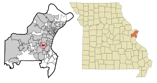
Hayti Heights is a city in eastern Pemiscot County in the bootheel of southeast Missouri, United States. The population was 515 at the 2020 census.

<span class="mw-page-title-main">Bella Villa, Missouri</span> City in Missouri, United States

Bella Villa is a city in St. Louis County, Missouri, in the United States. As of the 2010 census, the city population was 729.

<span class="mw-page-title-main">Country Club Hills, Missouri</span> City in Missouri, United States

Country Club Hills is a city in St. Louis County, Missouri, United States. The population was 1,274 at the 2010 census.

<span class="mw-page-title-main">Crystal Lake Park, Missouri</span> City in Missouri, United States

Crystal Lake Park is a Missouri Class 4 city in St. Louis County, Missouri, United States. The population was 508 at the 2020 census.

<span class="mw-page-title-main">Greendale, Missouri</span> City in Missouri, United States

Greendale is a city in St. Louis County, Missouri, United States. The population was 651 at the 2010 census.

<span class="mw-page-title-main">Northwoods, Missouri</span> City in Missouri, United States

Northwoods is a city in St. Louis County, Missouri, United States. The population was 4,227 at the 2010 census.

<span class="mw-page-title-main">Oakland, Missouri</span> City in Missouri, United States

Oakland is a city in St. Louis County, Missouri, United States. The population was 1,381 at the 2010 census.

<span class="mw-page-title-main">Pasadena Hills, Missouri</span> City in Missouri, United States

Pasadena Hills is a city in St. Louis County, Missouri, United States. The population was 930 at the 2010 census. The entire city is listed on the National Register of Historic Places.

<span class="mw-page-title-main">Velda City, Missouri</span> City in Missouri, United States

Velda City is a city in St. Louis County, Missouri, United States. The population was 1,420 at the 2010 census.

<span class="mw-page-title-main">Winchester, Missouri</span> City in Missouri, United States

Winchester is a city in St. Louis County, Missouri, United States. The population was 1,447 at the 2020 census.

<span class="mw-page-title-main">Henderson, Nebraska</span> City in York County, Nebraska, United States

Henderson is a city in York County, Nebraska, United States. The population was 991 at the 2010 census.

<span class="mw-page-title-main">Warson Woods, Missouri</span> City in Missouri, United States

Warson Woods is a city in St. Louis County, Missouri, United States. The population was 1,962 at the 2010 census.

<span class="mw-page-title-main">Meadow Bridge, West Virginia</span> Town in West Virginia, United States

Meadow Bridge is a town in Fayette County, West Virginia, United States. The population was 379 at the 2010 census. The first settler of the area was John Gwin, closely followed by Dan Griffin.

<span class="mw-page-title-main">Bowler, Wisconsin</span> Village in Wisconsin, United States

Bowler is a village in Shawano County, Wisconsin, United States. The population was 302 at the 2010 census.

<span class="mw-page-title-main">Wilson, Ohio</span> Village in Ohio, United States

Wilson is a village in Belmont and Monroe counties in the U.S. state of Ohio. The population was 129 at the 2020 census. It is part of the Wheeling metropolitan area.

References

  1. "ArcGIS REST Services Directory". United States Census Bureau. Retrieved August 28, 2022.
  2. 1 2 U.S. Geological Survey Geographic Names Information System: Essex, Missouri
  3. 1 2 "U.S. Census website". United States Census Bureau . Retrieved January 31, 2008.
  4. "Stoddard County Place Names, 1928–1945". The State Historical Society of Missouri. Archived from the original on June 24, 2016. Retrieved December 26, 2016.
  5. "Post Offices". Jim Forte Postal History. Retrieved December 26, 2016.
  6. "US Gazetteer files: 2010, 2000, and 1990". United States Census Bureau. February 12, 2011. Retrieved April 23, 2011.
  7. "US Gazetteer files 2010". United States Census Bureau. Archived from the original on January 25, 2012. Retrieved July 8, 2012.
  8. "Census of Population and Housing". Census.gov. Retrieved June 4, 2015.
  9. "U.S. Census website". United States Census Bureau . Retrieved July 8, 2012.
  10. Richland R1 Schools. Accessed 8 June 2020.
  11. State of Missouri District, Charters, and Schools. Accessed 8 June 2020.