Related Research Articles

São Vicente is one of the Barlavento Islands, the northern group within the Cape Verde archipelago in the Atlantic Ocean, off the West African coast. It is located between the islands of Santo Antão and Santa Luzia, with the Canal de São Vicente separating it from Santo Antão.

Caldas da Rainha is a medium-sized Portuguese city in the Oeste region, in the historical province of Estremadura, and in the district of Leiria. The city serves as the seat of the larger municipality of the same name and of the Comunidade Intermunicipal do Oeste. At the 2011 census, the municipality had a population of 51,729 in an area of 255.69 square kilometres (98.72 sq mi), with 30,343 residing in the city. Although the city itself lies about 10.5 kilometres (6.5 mi) inland, three of the municipality's civil parishes lie on the Atlantic Ocean. Caldas da Rainha is best known for its sulphurous hot springs and ceramic pottery.
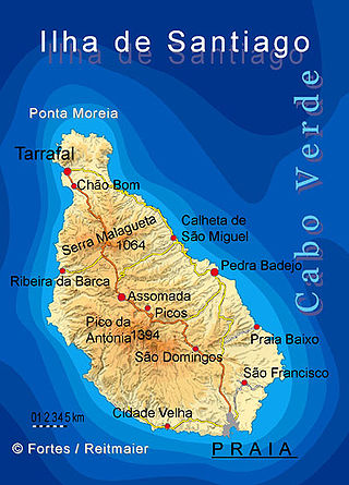
Santiago is the largest island of Cape Verde, its most important agricultural centre and home to half the nation's population. Part of the Sotavento Islands, it lies between the islands of Maio and Fogo. It was the first of the islands to be settled: the town of Ribeira Grande was founded in 1462. Santiago is home to the nation's capital city of Praia.

Espargos is the capital and main commercial centre of the island and municipality of Sal, Cape Verde. The city is situated in the heart of the island.

São Domingos de Benfica is a freguesia and district of Lisbon, the capital of Portugal. Located in northern Lisbon, São Domingos de Benfica is east of Benfica, south of Carnide, west of Alvalade, and north of Campolide. The population in 2011 was 33,043,

Brisa – Auto-estradas de Portugal, S.A. is a Portugal-based international transportation company. The group's largest business area is highway management, in which it is the largest concessionaire in its home country. Founded in 1972 by Jorge de Brito, Brisa also has operations in countries including the United States and the Netherlands. Since 2000 Brisa's largest shareholder has been the investment company Grupo José de Mello, which owns over 30% of its stock through subsidiaries. The Spanish infrastructure company Abertis holds around 15% of the firm. The company is listed on the Lisbon Stock Exchange and is a constituent of the benchmark PSI-20 and Euronext 100 indices. Its current CEO is António Pires de Lima.

Roads in Portugal are defined by the Plano Rodoviário Nacional, which describes the existing and planned network of Portuguese roads. The present plan in force is the 2000 National Road Plan (PRN 2000), approved in 1998. It replaced PRN 1985, which itself had replaced PRN 1945.
This article is related to roads in Cape Verde. There are three categories of national roads, rural roads (ER) and municipal roads (EM). Municipal roads are managed by the municipalities, the national and rural roads are managed by the Instituto de Estradas. The total length of the national road network is 1,113 km; the total length of the municipal road networks is 537 km. Of the national roads, 36% is asphalted. EN1 are first class national roads, EN2 are second class national roads and EN3 are third class national roads. Next is the first two letters which represent the island abbreviation, then the number. Only national roads are listed below.
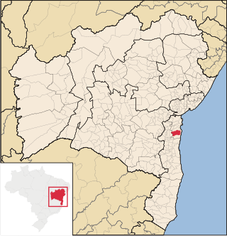
Coronel João Sá is a municipality in the state of Bahia in the North-East region of Brazil.
Camamu is a municipality in the state of Bahia, Brazil. Politically, it is in the Valença subregion of the Sul Baiano region. It is located on the southern coast of Bahia state, the Costa do Dendê, along the BA-001 highway. The municipality covers an area of 885.20 km², and, in a 2020 estimate, it had 35,382 inhabitants.
Duas Estradas is a municipality in the state of Paraíba in the Northeast Region of Brazil.

Cabedelo is a municipality of the Metropolitan Region of João Pessoa, in the state of Paraíba in the Northeast Region of Brazil.

Senador Sá is a municipality in the state of Ceará in the Northeast region of Brazil.

Jacareacanga is a municipality in the state of Pará in the Northern region of Brazil. It is at the very centre of South America.

Ewbank da Câmara is a municipality in the state of Minas Gerais, Brazil. Belonging to the mesoregion of the Zona da Mata and the microregion of Juiz de Fora, the municipality is located some 241 km to the southeast of the state capital, Belo Horizonte. In 2020, its population was 3,923, according to the Brazilian Institute of Geography and Statistics. It occupies an area of 103.834 km2. The urban area of the municipality constitutes a small part of the total. The rural area, predominantly in the municipality, has Atlantic rainforest vegetation.
The Road-rail bridge of Pocinho, commonly known as Pocinho Bridge, is a road-rail bridge in Vila Nova de Foz Côa, Portugal. The structure was part of the now defunct rail network Sabor line, and is now closed to both types of transit.

The National Historic and Artistic Heritage Institute is a heritage register of the federal government of Brazil. It is responsible for the preservation of buildings, monuments, structures, objects and sites, as well as the register and safeguard of intangible cultural heritage deemed of historic or cultural importance to the country.

Comunidade Intermunicipal do Oeste is an administrative division of Portugal, located on the country's western central coast. The population in 2011 was 362,540, in an area of 2,220.16 square kilometres (857.21 sq mi). Caldas da Rainha serves as the seat of Oeste.
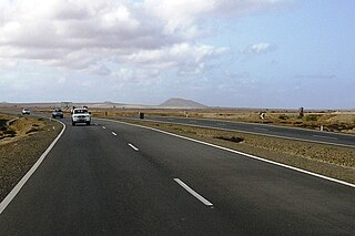
EN1-SL01 is a first class national road on the island of Sal, Cape Verde. It runs from Espargos to Santa Maria. It is Sal's only dual carriageway. In Espargos it is connected with EN1-SL-02 to Palmeira and EN3-SL-02 to Pedra de Lume. In Santa Maria it is connected with EN3-SL-01 to Ponta do Sinó.
References
- ↑ "Estradas de Portugal - Histórico". Archived from the original on 2007-02-26. Retrieved 2007-01-17.