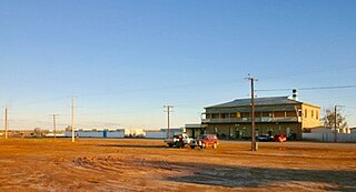
Marree is a small town located in the north of South Australia. It lies 589 kilometres (366 mi) North of Adelaide at the junction of the Oodnadatta Track and the Birdsville Track, 49 metres (161 ft) above sea level. Marree is an important service centre for the large sheep and cattle stations in northeast South Australia as well as a stopover destination for tourists traveling along the Birdsville or Oodnadatta Tracks.
Strzelecki Regional Reserve is a protected area located in the Australian state of South Australia in the gazetted localities of Lindon and Strzelecki Desert about 493 kilometres north-east of Port Augusta. It includes the Strzelecki Desert and the dry Strzelecki Creek bed. The regional reserve can only accessed via the historic Strzelecki Track. It is partly located on land that was included on the List of Wetlands of International Importance under the Ramsar Convention under the name Coongie Lakes in 1987. The regional reserve is classified as an IUCN Category VI protected area.

Coorong is a locality in the Australian state of South Australia which is associated with the lagoon known as the Coorong in the south-east of the state and which overlooks the continental coastline from the mouth of the Murray River about 80 kilometres south-east of the state capital of Adelaide to the immediate north of the town of Kingston SE extending for a distance of at least 140 kilometres (87 mi).

The Tirari Desert is a 15,250 square kilometres (5,888 sq mi) desert in the eastern part of the Far North region of South Australia. It stretches 212 km from north to south and 153 km from east to west.
Innamincka Regional Reserve is a protected area located in the north-east of South Australia which includes the town of Innamincka. The regional reserve was proclaimed on 22 December 1988 under National Parks and Wildlife Act 1972 over a parcel of land previously part of the Innamincka Pastoral Lease to recognise it as "a place of major conservation importance" whilst permitting ongoing mining and agricultural activity. It was the first "multiple use reserve to be administered by a nature conservation agency" to be declared in South Australia under the category of regional reserve provided for in the National Parks and Wildlife Act 1972. It is partly located on land that was included on the List of Wetlands of International Importance under the Ramsar Convention under the name Coongie Lakes in 1987. In 2005, a parcel of land was excised from the regional reserve to create the national park now known as Malkumba-Coongie Lakes National Park. It also includes the Innamincka/Cooper Creek state heritage area. The regional reserve is classified as an IUCN Category VI protected area.
The Lake Ngapakaldi to Lake Palankarinna Fossil Area is a group of fossil sites located in the Australian state of South Australia within the Tirari Desert in the north-eastern part of the state's Far North region. The group has an overall area of 35 square kilometres (14 sq mi) and is located about 70 kilometres (43 mi) east of Lake Eyre and about 100 kilometres (62 mi) north-north-east of Marree, off the Birdsville Track near Etadunna Station.

The Coongie Lakes is a freshwater wetland system located in the Far North region of South Australia. The 21,790-square-kilometre (8,410 sq mi) lakes system is located approximately 1,046 kilometres north of the Adelaide city centre. The wetlands includes lakes, channels, billabongs, shallow floodplains, deltas, and interdune swamps. It lies on the floodplain of Cooper Creek, an ephemeral river flowing through a desert landscape in the Lake Eyre Basin which rarely, after occasional large floods, empties into Lake Eyre. The wetland system has been recognised both as being of international importance by designation under the Ramsar Convention with a listing on 15 June 1987 and being nationally important within Australia with a listing in A Directory of Important Wetlands in Australia (DIWA). Its extent includes the regional town of Innamincka, the Malkumba-Coongie Lakes National Park, the Innamincka Regional Reserve, the Strzelecki Regional Reserve and the Coongie Lakes Important Bird Area.
Lake Hope is an ephemeral salt lake in the far north of South Australia.
Muloorina is both a pastoral lease that operates as a cattle station and a formal bounded locality in South Australia. The name and boundaries of the locality were created on 26 April 2013 after the long-established local name.

Chrome Downs is a pastoral lease that once operated as a sheep station but now operates as a cattle station in outback South Australia.
Elliot Price Conservation Park, formerly the Elliot Price Wilderness National Park, is a protected area in the Australian state of South Australia located in the gazetted locality of Lake Eyre with its southern boundary being located about 90 kilometres north west of Marree.
False Bay is a locality in South Australia on the north east corner of Eyre Peninsula located north of the city of Whyalla overlooking the bay in Spencer Gulf known as False Bay.
Secret Rocks is a locality in the Australian state of South Australia located on the Eyre Peninsula about 36 kilometres to the east of the town of Kimba and about 227 kilometres north west of the state capital of Adelaide.
Emeroo is a locality in the Australian state of South Australia about 295 kilometres north of the state capital of Adelaide and about 18 kilometres northeast of Port Augusta in the state’s Far North region.

Lake Gilles is a locality in the Australian state of South Australia located on the Eyre Peninsula about 278 kilometres north west of the state capital of Adelaide and about 35 kilometres to the north-east of the town of Kimba.

Flinders Ranges is a locality in the Australian state of South Australia located in the mountain range of the same name, about 380 km (240 mi) north of the state capital of Adelaide, about 86 km (53 mi) north-east of the municipal seat of Quorn and about 131 km (81 mi) north-east of the centre of Port Augusta in the state's Far North region.

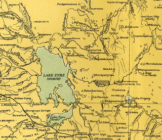
Lake Eyre is a locality in the Australian state of South Australia located about 718 kilometres north of the state capital of Adelaide and 134 kilometres north of the town of Marree and which is associated with the occasional body of water known as Lake Eyre.
Gidgealpa is a locality in the Australian state of South Australia located about 780 kilometres north-east of the capital city of Adelaide and about 58 kilometres south-west of the town of Innamincka.
Wallerberdina is a locality in the Australian state of South Australia located about 345 kilometres (214 mi) north of the state capital of Adelaide and about 40 kilometres (25 mi) west of the town of Hawker.
Allandale Station is a locality in the Australian state of South Australia located about 848 kilometres (527 mi) north of the state capital of Adelaide and about 20 kilometres (12 mi) south-east of the town of Oodnadatta.
