Ethel Kennedy Bridge

Last updated

Ethel Kennedy Bridge
Benning Bridge 2018.jpg
The Ethel Kennedy Bridge from the south in October 2018, with the Metro bridge visible behind and above it
Coordinates 38°53′50″N76°57′49″W / 38.897195°N 76.963649°W / 38.897195; -76.963649
CarriesMotor vehicles, pedestrians
Crosses Anacostia River, Kingman Island
Locale Washington, D.C., U.S.
Other name(s)Benning Road Bridge
Named for Ethel Kennedy
Owner District Department of Transportation
Preceded byWashington Metro bridge
Followed by Whitney Young Memorial Bridge
Characteristics
Design Plate girder bridge
Total length548 feet (167 m) [1]
No. of spans5
History
Construction start2002
Construction end2004
Statistics
Daily traffic 68,400 vehicles per day (1990) [2]
TollFree both ways
Location
Ethel Kennedy Bridge

The Ethel Kennedy Bridge is a beam bridge built in 2004 that carries Benning Road over the Anacostia River in Washington, D.C. It is an eight-lane bridge with pedestrian lanes on both sides. A separate Washington Metro bridge carrying the Blue, Orange and Silver lines crosses over the bridge near its western terminus, and parallels the bridge on the north. A third bridge in the area carries Benning Road over Kingman Lake. [3]

Contents

History

Stoddert's Bridge

In 1797, the state of Maryland (which then controlled the area which would later become the District of Columbia) issued a charter to Benjamin Stoddert, Thomas Law, and John Templeman to build a bridge across the Anacostia River. [4] [5] Stoddert owned land (known as "Long Meadows") on the eastern shore of the Anacostia River, and a bridge would have helped him develop him land. [4] The right to build a bridge was not exercised until 1805, when Chain Bridge was swept away during floods. [4] [5] Stoddert then formed the Anacostia Bridge Co., and that same year erected a $20,000 wooden bridge known as Stoddert's Bridge in this location. [4] [5] In the 1790s, "Captain" William Benning came from Virginia and purchased 330 acres (1.3 km2) of land on the western end of Stoddert's Bridge. [6] The site was one of the first crossings over the Anacostia River. [7] The bridge and "Benning's Road" were important eastern routes in and out of the District. [7] [8] [9]

By 1814, the bridge—now also known as "Upper Bridge"—was in disrepair. [10] During the War of 1812, the U.S. military commander of the Military District of Washington burned Stoddert's Bridge in an attempt to stop the British from invading the city of Washington. [11] [12] [13] On March 3, 1815, the United States Congress passed legislation reimbursing the Anacostia Bridge Co. for the destruction of its bridge. [14]

Ewell's Bridge

The Bridge across the Eastern Branch (Anacostia River) in April 1865 Bridge across Eastern branch of Potomac River 34794v.jpg
The Bridge across the Eastern Branch (Anacostia River) in April 1865

The bridge was rebuilt in 1815 by Dr. Thomas Ewell, who renamed it Ewell's Bridge (although it was also known as the "Anacostia Bridge"). [15] In 1825, Ewell sold the bridge to Benning, who renamed it Benning's Bridge. [15]

Benning's Bridge

Benning built a new bridge at the site in the 1830s (although not all sources agree on the exact date). [16]

After a major flood in 1840, the bridge was repaired. [13] It was purchased in August 1848 by the federal government and the toll removed. [17] In disrepair due to the large amount of traffic over the span, it was almost completely rebuilt in 1868. [18]

1892 Bridge

Ewell's Bridge was replaced with a steel bridge in 1892. [19] [20]

Benning Road Bridge

Photo of the Benning Road Bridge constructed in 1934 1934 Benning Road Bridge.jpg
Photo of the Benning Road Bridge constructed in 1934

Work on a replacement to that bridge began in January 1933 and cost $450,000 at the time. The 8-span bridge made of steel beams encased in concrete on simple spans opened on December 18, 1934. It was 586 feet long, 106 feet wide with 8' sidewalks on each side. [13] [21] In 1975, the west bound deck was replaced. [22]

Ethel Kennedy Bridge

The Metro and road bridges side-by-side Benning Bridge underside 2018.jpg
The Metro and road bridges side-by-side

In the late 1990s an analysis of the existing bridge showed that the bridge was unsuitable for rehabilitation and that it needed to be replaced. The replacement was broken into two bridges, with one over Kingman Lake and the other over the Anacostia. The bridge over Kingman Lake was built in 2000.

In 2002-2003, the Benning Road Reconstruction Project replaced the 586-foot bridge built in 1934 with a 548-foot, 8-lane, 5-span, continuous, multi-girder bridge with steel elements masked by concrete panels to closely resemble the 1934 span. [23] [1] [24] [25] The new bridge, like the one it replaced, carries water, gas, electricity and phone lines. It also included wide sidewalks, a new pedestrian gateway to Kingman Island and connections to the RiverParks on both sides of the river. [26] [27]

In 2008, the District Council voted to rename the Benning Road Bridge after Ethel Kennedy, the widow of the late Robert F. Kennedy, for whom a nearby stadium was named. In a May 20, 2014, ceremony, the bridge was officially renamed the Ethel Kennedy Bridge to honor her for her devotion to many social and environmental causes during her later years, especially in the neighborhoods along and near the Anacostia River. [28]

The Bridge was inspected by the District of Columbia Department of Transportation (DDOT) in 2014, and found to be structurally sound. [29]

Related Research Articles

<span class="mw-page-title-main">Northeast (Washington, D.C.)</span> Place in the United States

Northeast is the northeastern quadrant of Washington, D.C., the capital of the United States. It encompasses the area located north of East Capitol Street and east of North Capitol Street.

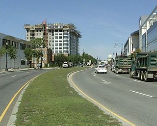
Benning Road is a major traveled street in Washington, D.C., and Prince George's County, Maryland.

<span class="mw-page-title-main">Interstate 695 (District of Columbia)</span> Interstate Highway in the DC area

Interstate 695 (I-695) is a two-mile-long (3.2 km) auxiliary Interstate Highway in Washington DC. It is also known as the Southeast Freeway. It travels from an interchange with I-395 south of the US Capitol building east then south across the 11th Street Bridges to an intersection with I-295 and District of Columbia Route 295 (DC 295) in Anacostia.

<span class="mw-page-title-main">Whitney Young Memorial Bridge</span> Bridge in D.C., U.S.

The Whitney Young Memorial Bridge is a bridge that carries East Capitol Street across the Anacostia River in Washington, D.C. in the United States. Finished in 1955, it was originally called the East Capitol Street Bridge. It was renamed for civil rights activist Whitney Young in early 1974. The bridge is 1,800 feet (550 m) long, its six lanes are 82 feet (25 m) wide, and it has 15 spans resting on 14 piers.

<span class="mw-page-title-main">John Philip Sousa Bridge</span> Bridge in Washington, D.C., United States

The John Philip Sousa Bridge, also known as the Sousa Bridge and the Pennsylvania Avenue Bridge, is a continuous steel plate girder bridge that carries Pennsylvania Avenue SE across the Anacostia River in Washington, D.C., in the United States. The bridge is named for famous United States Marine Band conductor and composer John Philip Sousa, who grew up near the bridge's northwestern terminus.

<span class="mw-page-title-main">South Capitol Street</span>

South Capitol Street is a major street dividing the southeast and southwest quadrants of Washington, D.C., in the United States. It runs south from the United States Capitol to the D.C.–Maryland line, intersecting with Southern Avenue. After it enters Maryland, the street becomes Indian Head Highway at the Eastover Shopping Center, a terminal or transfer point of many bus routes.

<span class="mw-page-title-main">11th Street Bridges</span> Complex of three bridges across the Anacostia River in Washington, D.C.

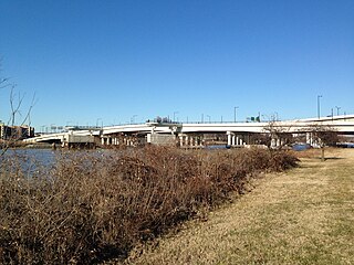
The 11th Street Bridges are a complex of three bridges across the Anacostia River in Washington, D.C., United States. The bridges convey Interstate 695 across the Anacostia to its southern terminus at Interstate 295 and DC 295. The bridges also connect the neighborhood of Anacostia with the rest of the city of Washington.

<span class="mw-page-title-main">Kingman Park</span> Place in the United States

Kingman Park is a residential neighborhood in the Northeast quadrant of Washington, D.C., the United States capital city. Kingman Park's boundaries are 15th Street NE to the west; C Street SE to the south; Benning Road to the north; and Anacostia Park to the east. The neighborhood is composed primarily of two-story brick rowhouses. Kingman Park is named after Brigadier General Dan Christie Kingman, the former head of the United States Army Corps of Engineers.

<span class="mw-page-title-main">Barney Circle</span> Neighborhood in the United States

Barney Circle is a small residential neighborhood located between the west bank of the Anacostia River and the eastern edge of Capitol Hill in southeast Washington, D.C., in the United States. The neighborhood is characterized by its sense of community, activism, walkability, and historic feel. The neighborhood's name derives from the eponymous former traffic circle Pennsylvania Avenue SE just before it crosses the John Philip Sousa Bridge over the Anacostia. The traffic circle is named for Commodore Joshua Barney, Commander of the Chesapeake Bay Flotilla in the War of 1812.

<span class="mw-page-title-main">Kingman Island</span>

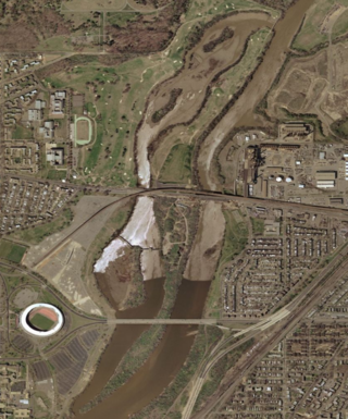
Kingman Island and Heritage Island are islands in Northeast and Southeast Washington, D.C., in the Anacostia River. Both islands are man-made, built from material dredged from the Anacostia River and completed in 1916. Kingman Island is bordered on the east by the Anacostia River, and on the west by 110-acre (45 ha) Kingman Lake. Heritage Island is surrounded by Kingman Lake. Both islands were federally owned property managed by the National Park Service until 1995. They are currently owned by the D.C. government, and managed by Living Classrooms National Capital Region. Kingman Island is bisected by Benning Road and the Ethel Kennedy Bridge, with the southern half of the island bisected again by East Capitol Street and the Whitney Young Memorial Bridge. As of 2010, Langston Golf Course occupied the northern half of Kingman Island, while the southern half of Kingman Island and all of Heritage Island remained largely undeveloped. Kingman Island, Kingman Lake and nearby Kingman Park are named after Brigadier General Dan Christie Kingman, the former head of the United States Army Corps of Engineers.

<span class="mw-page-title-main">Kingman Lake</span>

Kingman Lake is a 110-acre (0.45 km2) artificial lake located in the Anacostia River in Washington, D.C., in the United States. The lake was created in 1920 when the United States Army Corps of Engineers used material dredged from the Anacostia River to create Kingman Island. The Corps of Engineers largely blocked the flow of the Anacostia River to the west of Kingman Island, creating the lake. Kingman Lake is currently managed by the National Park Service.

<span class="mw-page-title-main">Greenway (Washington, D.C.)</span> Neighborhood in Ward 7, United States

Greenway is a residential neighborhood in Southeast Washington, D.C., in the United States. The neighborhood is bounded by East Capitol Street to the north, Pennsylvania Avenue SE to the south, Interstate 295 to the west, and Minnesota Avenue to the east.

Eastern Avenue is one of three boundary streets between Washington, D.C., and the state of Maryland. It follows a northwest-to-southeast line, beginning at the intersection of 16th Street NW and Colesville Road. It intersects with Blair Road NW, and ceases to exist for about 1,000 feet (300 m). Another interruption occurs at Cedar Street NW. A 3,000-foot (910 m) interruption occurs again at Galloway Street NE, where the park land of the North Michigan Park Recreation Center exists. It continues without interruption until it reaches Bladensburg Road NE. There is a 1.8-mile (2.9 km) interruption in the avenue along Fort Lincoln Cemetery. The avenue has no crossing over New York Avenue NE or the Anacostia River, or through Anacostia Park. It resumes at Kenilworth Avenue NE, with its terminus at its junction with Southern Avenue.

<span class="mw-page-title-main">DC Streetcar</span> Streetcar system in Washington, D.C.

The DC Streetcar is a surface streetcar network in Washington, D.C. As of 2017, it consists of only one line: a 2.2-mile (3.5 km) segment running in mixed traffic along H Street and Benning Road in the city's Northeast quadrant.

<span class="mw-page-title-main">District Department of Transportation</span> United States agency

The District Department of Transportation is an agency of the government of the District of Columbia, in the United States, which manages and maintains publicly owned transportation infrastructure in the District of Columbia. DDOT is the lead agency with authority over the planning, design, construction, and maintenance of alleys, bridges, sidewalks, streets, street lights, and traffic signals in the District of Columbia.

<span class="mw-page-title-main">Martin Luther King Jr. Avenue</span> Street in District of Columbia, USA

Martin Luther King Jr. Avenue is a major street in the District of Columbia traversing through both the Southwest and Southeast quadrants.

<span class="mw-page-title-main">New York Avenue Bridge (Anacostia River)</span> Bridge in D.C., U.S.

The New York Avenue Bridge is a bridge carrying U.S. Route 50 and New York Avenue NE over the Anacostia River in Washington, D.C., in the United States. It was completed in 1954 as part of the Baltimore–Washington Parkway project.

<span class="mw-page-title-main">H Street/Benning Road Line</span> DC Streetcar line

The H Street/Benning Road Line is a currently operating line of DC Streetcar. It has eight stations and began operation on February 27, 2016. The 2.4-mile (3.9 km) line runs along H Street NE and Benning Road NE in Washington, D.C. In September 2016 service was increased from six days a week to seven, and with shorter 12-minute headways.

<span class="mw-page-title-main">Anacostia Line</span>

The Anacostia Line is a partially constructed line of the DC Streetcar, never put into service, intended to connect the Anacostia neighborhood with Joint Base Anacostia–Bolling. Construction occurred in 2009 and 2010, but was terminated before the line was complete.

<span class="mw-page-title-main">Anacostia Riverwalk Trail</span> 25 mile multi-use trail system in Washington D.C.

The Anacostia Riverwalk Trail is a multi-use trail system in Washington, DC, which, when complete, will be ~25 miles long, spanning both sides of the Anacostia River, the Washington Channel waterfront, and projecting into neighborhoods away from the Anacostia. It has more recently been branded as part of a larger Anacostia Riverwalk Trail Network which includes an additional 8 segments and 15 miles of trail. On the north end it connects to the Anacostia Tributary Trail System; on the south end it will connect to the Oxon Hill Farm Trail and on the west it connects to the Rock Creek Park Trail and the 14th Street Bridge. Of the 19 planned segments, 14 are complete for a combined total of 16 miles.

References

  1. 1 2 "Benning Road Bridge Replacement over the Anacostia River". volkertengineering.com. Volkert Engineering, P.C. Retrieved October 11, 2018.
  2. "2009 Data. National Bridge Inventory". Federal Highway Administration . United States Department of Transportation. 2009. Retrieved July 5, 2010.
  3. "Benning Road Bridges" (PDF). DDOT. September 2019.
  4. 1 2 3 4 Bryan, Wilhelmus Bogart (1914). A History of the National Capital From Its Foundation Through the Period of the Adoption of the Organic Act. Vol. 1. New York: The Macmillan Company. p.  492 via Internet Archive.
  5. 1 2 3 Croggon, James (August 17, 1906). "When City Was Young". The Washington Evening Star via Bytes of History.
  6. Deanwood History Committee (2008). Washington, D.C.'s Deanwood. Charleston, S.C.: Arcadia Publishing. p. 7. ISBN   9780738553504.
  7. 1 2 Lapp, Joe (February 2006). "Kenilworth: A D.C. Neighborhood by the Anacostia River" (PDF). Humanities Council of Washington D.C. Archived from the original (PDF) on May 27, 2010. Retrieved May 7, 2010.
  8. Lapp, Joe (November 2005). "Kenilworth: A Northeast Neighborhood by the Anacostia River" (PDF). East of the River. Capital Community News, Inc. Retrieved May 7, 2010.
  9. Upper Marlboro-East Washington, DC Quadrangle, Northwest Quadrant, USGS (1886)("Benning's Road" appears on 1886 USGS Map) Archived July 16, 2011, at the Wayback Machine
  10. Lord, Walter (1994). The Dawn's Early Light. Baltimore, Maryland: Johns Hopkins University Press. p. 93. ISBN   9781421405476.
  11. Lord, The Dawn's Early Light, 1994, p. 96
  12. Muller, Charles Geoffrey. The Darkest Day—1814: The Washington-Baltimore Campaign. Philadelphia: University of Pennsylvania Press, 2003, p. 111.
  13. 1 2 3 Wheeler, Linda (October 25, 1997). "Benning Heights' Twists and Turns". The Washington Post .
  14. Maggie Houston. Report No. 587. Committee on War Claims. U.S. House of Representatives. 52d Cong., 2d Sess. March 14, 1894, p. 6.
  15. 1 2 Bryan, Wilhelmus Bogart. A History of the National Capital From Its Foundation Through the Period of the Adoption of the Organic Act. Vol. 2. New York: The Macmillan Company, 1916, p. 98-99.
  16. "Local roads scholars give streets'history". The Washington Times . June 25, 1992. Retrieved May 7, 2010.
  17. Turnpike Roads in District of Columbia. Minority Report. Committee on the District of Columbia. U.S. House of Representatives. Report No. 410. 35th Cong., 1st Sess. May 24, 1858, p. 2.
  18. Letter of the Secretary of War, March 22, 1869. Exec. Doc. No. 100. United States Senate. 41st Cong., 1st Sess. June 20, 1870, p. 2.
  19. Wasserman, Paul & Hausrath, Don. Washington, D.C. From A to Z, p.33 (2003) ( ISBN   978-1931868075)
  20. Scott, Pamela. Capital Engineers: The U.S. Army Corps of Engineers in the Development of Washington, D.C., 1790–2004. Washington, D.C.: U.S. Army Corps of Engineers, 2007, p. 124.
  21. "New Benning Bridge Complete". The Evening Star. December 18, 1934.
  22. Feaver, Douglas B. (September 15, 1975). "Four Bridges to Be Restored: Resurfacing Set For Four Bridges". The Washington Post.
  23. Ramstack, Tom (May 8, 2002). "Bridge work - D.C. spans ranked most deficient". The Washington Times.
  24. "Benning Road Bridge Replacement | Volkert". volkert.com. Volkert, Inc. Retrieved October 11, 2018.
  25. District of Columbia Appropriations for 2005: Justifications. U.S. Government Printing Office. 2004. p. 1579.
  26. District of Columbia Appropriations for Fiscal Year 2003. U.S. Government Printing Office. 2003. p. 278. Retrieved November 27, 2019.
  27. The Anacostia Waterfront Framework Plan. District of Columbia, Office of Planning. 2003. p. 55. Retrieved November 27, 2019.
  28. DeBonis, Mike (May 21, 2014). "Ethel Kennedy Bridge is dedicated, at long last". The Washington Post. Retrieved April 11, 2016.
  29. Dildine, Dave (June 25, 2015). "DDOT details area's structurally deficient bridges". WTOP. Retrieved September 1, 2015.