A trail, also known as a path or track, is an unpaved lane or a small paved road not intended for usage by motorized vehicles, usually passing through a natural area. In the United Kingdom and Ireland, a path or footpath is the preferred term for a pedestrian or hiking trail. The term is also applied in North America to accompanying routes along rivers, and sometimes to highways. In the US, the term was historically used for a route into or through wild territory used by explorers and migrants. In the United States, "trace" is a synonym for trail, as in Natchez Trace.

Hiking is a long, vigorous walk, usually on trails or footpaths in the countryside. Walking for pleasure developed in Europe during the eighteenth century. Religious pilgrimages have existed much longer but they involve walking long distances for a spiritual purpose associated with specific religions.

A footpath is a type of thoroughfare that is intended for use only by pedestrians and not other forms of traffic such as motorized vehicles, bicycles and horses. They can be found in a wide variety of places, from the centre of cities, to farmland, to mountain ridges. Urban footpaths are usually paved, may have steps, and can be called alleys, lanes, steps, etc.

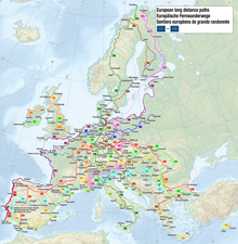
The GR footpaths are a network of long-distance walking trails in Europe, mostly in France, Belgium, the Netherlands, and Spain. They go by the following names: French: sentier de grande randonnée, West Flemish: Groteroutepad, Dutch: Langeafstandwandelpad, Spanish: sendero de gran recorrido, Portuguese: percurso pedestre de grande rota – generally meaning "long trail" or more literally "great route". The trails in France alone cover approximately 60,000 kilometres (37,000 mi). Trails are blazed with characteristic marks consisting of a white stripe above a red stripe. These appear regularly along the route, especially at places such as forks or crossroads.

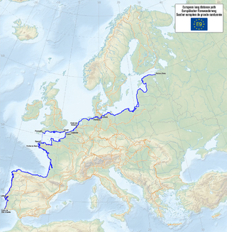
The E2 European long distance path or E2 path is a 4850 km (3010-mile) series of long-distance footpaths that is intended to run from Galway in Ireland to France's Mediterranean coast and currently runs through Northern Ireland, Scotland, England, Belgium, Luxembourg and France, with an alternative midsection equally designated via the Netherlands and east coast of England. It is one of the network of European long-distance paths.

The Southern Upland Way is a 344-kilometre (214 mi) coast-to-coast long-distance footpath in southern Scotland. The route links Portpatrick in the west and Cockburnspath in the east via the hills of the Southern Uplands. The Way is designated as one of Scotland's Great Trails by NatureScot and is the longest of the 29 Great Trails. The Southern Upland Way meets with seven of the other Great Trails: the Annandale Way, the Berwickshire Coastal Path, the Borders Abbeys Way, the Cross Borders Drove Road, the Mull of Galloway Trail, the Romans and Reivers Route and St Cuthbert's Way.

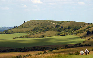
The Icknield Way Path or Icknield Way Trail is a long distance footpath and riding route in East Anglia, England. The ancient Icknield Way itself is unique among long-distance trails because it can claim to be ‘the oldest road in Britain’. It consists of prehistoric pathways, ancient when the Romans came; the route is dotted with archaeological remains. It survives today in splendid tracks and green lanes along the ‘chalk spine’ of southern England.
The E9 European long distance path, E9 path or European Coastal Path is one of more European long-distance paths, running for 9880 km from Tarifa, Spain to Narva-Jõesuu in Estonia. In 2019, the southern terminus was extended from Cabo de São Vicente in Portugal to Tarifa in Spain, the southern-most point of continental Europe, and also the starting point of E4 and E12.
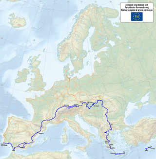
The E4 European long distance path or E4 path is one of the European long-distance paths. Starting at Tarifa Andalusia, located at the southernmost end of the Iberian Peninsula, across the Strait of Gibraltar facing Morocco, it continues through Spain, France, Switzerland, Germany, Austria, Hungary, Romania, Bulgaria and Greece to end in Cyprus. It also visits the Greek island of Crete.
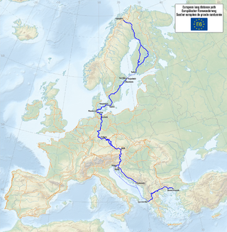
The E6 European long distance path or E6 path is one of the European long-distance paths from the northwest tip of Finland through Sweden, Denmark, Germany and Austria to the Adriatic coast in Slovenia. A second section starts again in Greece to finish in Turkey.
Walking is one of the most popular outdoor recreational activities in the United Kingdom, and within England and Wales there is a comprehensive network of rights of way that permits access to the countryside. Furthermore, access to much uncultivated and unenclosed land has opened up since the enactment of the Countryside and Rights of Way Act 2000. In Scotland the ancient tradition of universal access to land was formally codified under the Land Reform (Scotland) Act 2003. In Northern Ireland, however, there are few rights of way, or other access to land.
Ramblers is the trading name of the Ramblers Association Great Britain's walking charity. The Ramblers is also a membership organisation with around 100,000 members and a network of volunteers who maintain and protect the path network. The organisation was founded in 1935 and campaigns to keep the British countryside open to all.

A long-distance trail is a longer recreational trail mainly through rural areas used for hiking, backpacking, cycling, horse riding or cross-country skiing. They exist on all continents except Antarctica.

The GR 7 is a long-distance footpath in Spain, Andorra and France. It is part of both the Spanish network of Senderos de Gran Recorrido and the French network of Sentiers de Grandes Randonnées. Part of GR 7 forms the south-westernmost part of the European walking route E4 in Spain. GR 7 runs from Tarifa, near Gibraltar, across Spain, through France into Andorra, and back into France to Mont Aigoual and Aire-de-Côte in the Cevennes. GR 7 continues north from the Cevennes mountains and the final 250 km end on the top of the Ballon d'Alsace, Alsace, northern France; here it meets E5.
The European Ramblers Association is a network organisation working for promotion of walking, hiking, creating trails, exchange of the know-how over the borders and secure the rights of free access to nature for the walkers. Through this work, ERA also cares for protecting and developing of European cultural heritage and for strengthening of mutual understanding between European citizens.
The GR 128 is a long-distance hiking trail in northern France, Belgium, and the Netherlands, in an east–west direction ending in Germany.

The GR 14 is a Percurso pedestre de grande rota in Portugal, which connects with a corresponding path into Spain. In Portugal, it is known as the Rota dos Vinhos da Europa, and Portuguese tourist maps mark it as continuing through wine-growing areas of Spain and France to terminate at Strasbourg. As of 2015 it is not included in the list of "E-paths" published by the European Ramblers' Association; however, a long-distance route of the same number (GR 14, known as the Senda del Duero does continue the route into Spain from the border at Salto de Saucelle

The Transcaucasian Trail (TCT) is a long-distance hiking trail under development in the Caucasus through Georgia, Azerbaijan and Armenia. It has been called one of the world's greatest places by Time in 2019.

The sentier de Grande Randonnée 8, or GR 8 for short, is a long distance hiking trail on the French Atlantic coast. It is part of the Grande Randonnée network and runs from Saint-Brevin-les-Pins on the south of the Loire estuary, opposite the large port city of Saint-Nazaire and currently terminates at Sare in the Atlantic Pyrenees.