The Little Kanawha River is a tributary of the Ohio River, 169 mi (269 km) long, in western West Virginia in the United States. Via the Ohio, it is part of the watershed of the Mississippi River, draining an area of 2,320 mi² (6,009 km²) on the unglaciated portion of the Allegheny Plateau. It served as an important commercial water route in the early history of West Virginia, particularly in the logging and petroleum industries.

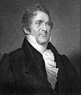
William Wirt was an American author and statesman who is credited with turning the position of United States Attorney General into one of influence. He was the longest serving Attorney General in U.S. history. He was also the Anti-Masonic nominee for president in the 1832 election.
The Parkersburg–Marietta–Vienna Metropolitan Statistical Area, as defined by the United States Census Bureau, is an area consisting of three counties in West Virginia and one in Ohio, anchored by the cities of Parkersburg, West Virginia, Marietta, Ohio, and Vienna, West Virginia. As of the 2000 census, the MSA had a population of 164,264.

Munday is an unincorporated community in eastern Wirt County, West Virginia, United States. It lies along local roads southeast of the town of Elizabeth, the county seat of Wirt County. Its elevation is 717 feet (217 m). Munday had a post office, which closed on October 26, 2002.

Creston is an unincorporated community in southeastern Wirt County, West Virginia, United States. It lies at the confluence of the Little Kanawha River and the West Fork Little Kanawha River on West Virginia Route 5, southeast of the town of Elizabeth, the county seat of Wirt County. Its elevation is 653 feet (199 m). Creston had a post office, which closed on June 25, 2011. The community was named for a drainage divide near the town site.

Peewee is an unincorporated community in southwestern Wirt County, West Virginia, United States. It lies along local roads southwest of the town of Elizabeth, the county seat of Wirt County. Its elevation is 679 feet (207 m). Right Reedy Creek is formed at Peewee by the confluence of Enoch Fork and Fulls Fork.

Hughes River Wildlife Management Area is located in Wirt County and Ritchie County near Parkersburg, West Virginia. Located on 10,000 acres (4,000 ha) that border both the Little Kanawha River and the Hughes River. The WMA terrain varies from river bottom to steep hillsides covered with second growth oak-hickory hardwood stands and younger pine-hardwood woodlots.
West Virginia's 4th congressional district is an obsolete district existing from 1883 to 1993. While the district's bounds were changed many times over the years, from the 1940 redistricting to the 1970 redistricting, the district was focused on Huntington and the industrial mill towns north of that city. In the 1970 redistricting, the district focused on Huntington and the rural coal producing areas of southwestern West Virginia. Today most of the last version of the old 4th District is the western half of the current 3rd District.
Palestine, West Virginia may refer to:

This is a list of the National Register of Historic Places listings in Wirt County, West Virginia.

Lucile is an unincorporated community in Wirt County, West Virginia, United States. Lucile is located on West Virginia Route 14 and Reedy Creek 4 miles (6.4 km) northeast of Reedy.

Sanoma is an unincorporated community in Wirt County, West Virginia, United States. Sanoma lies at the confluence of the Little Kanawha River and Spring Creek, 8 miles (13 km) southeast of Elizabeth; County Route 36 passes through the community.

The 1992 United States presidential election in West Virginia took place on November 3, 1992, as part of the 1992 United States presidential election. Voters chose five representatives, or electors to the Electoral College, who voted for president and vice president.

Standingstone was an unincorporated community in Wirt County, West Virginia.

Enterprise is an unincorporated community in Wirt County, West Virginia.

Two Run is an unincorporated community in Wirt County, West Virginia.

Morristown is an unincorporated community in Wirt County, West Virginia.

Wirt County High School (WCHS) is a secondary school located in Elizabeth, West Virginia, United States, that serves grades nine through twelve. It is in Wirt County, West Virginia.


