
Oman is a country on the southeast coast of the Arabian Peninsula, situated in Southwest Asia, bordering the Arabian Sea, Gulf of Oman, and Persian Gulf, between Yemen and the United Arab Emirates (UAE). The coast of Oman was an important part in the Omani empire and sultanate.
The economy of Oman is mainly centered around its oil sector, with fishing and trading activities located around its coastal regions. When oil was discovered in 1964, the production and export increased significantly. The government has made plans to diversify away from oil under its privatization and Omanization policies. This has helped raise Oman's GDP per capita continuously in the past 50 years. It grew 339% in the 1960s, reaching a peak growth of 1,370% in the 1970s. Similar to the pricing of all other commodities, the price of oil is subject to significant fluctuations over time, especially those associated with the business cycle. A commodity's price will rise sharply when demand, like that for oil, outpaces supply; meanwhile, when supply outpaces demand, prices will fall.

The United Arab Emirates is situated in the Middle East and southwest Asia, bordering the Gulf of Oman and the Persian Gulf, between Oman and Saudi Arabia; it is at a strategic location along the northern approaches to the Strait of Hormuz, a vital transit point for world crude oil. The UAE lies between 22°50′ and 26° north latitude and between 51° and 56°25′ east longitude. It shares a 19 km (12 mi) border with Qatar on the northwest, a 530 km (330 mi) border with Saudi Arabia on the west, south, and southeast, and a 450 km (280 mi) border with Oman on the southeast and northeast.
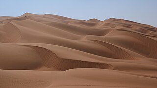
The Rub' al Khali, the "Empty Quarter") is the sand desert (erg) encompassing most of the southern third of the Arabian Peninsula. The desert covers some 650,000 km2 (250,000 sq mi) including parts of Saudi Arabia, Oman, the United Arab Emirates, and Yemen. It is part of the larger Arabian Desert.

Sir Wilfred Patrick Thesiger, also known as Mubarak bin Landan was a British military officer, explorer, and writer.
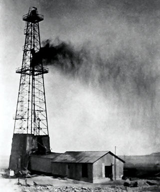
Petroleum Development Oman (PDO) is the leading exploration and production company in the Sultanate of Oman. The Company delivers the majority of the country's crude oil production and natural gas supply. The company is owned by the Government of Oman, Royal Dutch Shell (34%), TotalEnergies (4%) and Partex (2%). The first economic oil find was made in 1962, and the first oil consignment was exported in 1967.
The Sultan of Oman's Armed Forces are the Royal Army of Oman, Royal Navy of Oman, Royal Air Force of Oman, Sultan's Special Force and other defense forces of the Sultanate of Oman. Since their formal establishment in the early 1950s, with British assistance SAF has twice overcome insurgencies which have threatened the integrity or social structure of the state, and more recently have contributed contingents or facilities to coalitions formed to protect Arab states of the Persian Gulf.

Ghalib bin Ali bin Hilal al-Hinai was the last elected Imam (ruler) of the Imamate of Oman.

The Musandam Peninsula, locally known as Ruus Al Jibal, is a peninsula that forms the northeastern point of the Arabian Peninsula. It is located to the south of the Strait of Hormuz between the Persian Gulf and Gulf of Oman. It is inhabited by the Shihuh tribe and is mainly governed by Oman as the Musandam Governorate with certain parts governed by the United Arab Emirates, including Ras Al Khaimah and parts of Dibba.
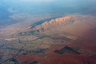
Jabal Hafeet is a mountain in the region of Tawam, on the border of the United Arab Emirates and Oman, which may be considered an outlier of Al Hajar Mountains in Eastern Arabia. Due to its proximity to the main Hajar range, the mountain may be considered as being part of the Hajar range. To the north is the UAE city of Al Ain, in the Eastern Region of the Emirate of Abu Dhabi, and the adjacent Omani town of Al-Buraimi.

The Dhofar Rebellion, also known as the Dhofar War or the Omani Civil War, was waged from 1963 to 1976 in the province of Dhofar against the Sultanate of Muscat and Oman. The war began with the formation of the Dhofar Liberation Front, a group which aimed to create an independent state in Dhofar, free from the rule of the Omani Sultan Said bin Taimur. The rebels also held the broader goals of Arab nationalism which included ending British influence in the Persian Gulf region.
Duqm is a port town on the Arabian Sea in central-eastern Oman. As of 2010, the population was 11,200.

The Arabian leopard is a leopard subspecies native to the Arabian Peninsula. It has been listed as Critically Endangered on the IUCN Red List since 1996 as fewer than 200 wild individuals were estimated to be alive in 2006. The population is severely fragmented. Subpopulations are isolated and not larger than 50 mature individuals. The population is thought to decline continuously.
Saudi Arabian oil was first discovered by the Americans in commercial quantities at Dammam oil well No. 7 in 1938 in what is now modern day Dhahran.

The Hajar Mountains in northeastern Oman and also the eastern United Arab Emirates are the highest mountain range in the eastern Arabian peninsula. Also known as "Oman Mountains", they separate the low coastal plain of Oman from the high desert plateau, and lie 50–100 km (31–62 mi) inland from the Gulf of Oman.

Douglas Michael "Mike" Morton was a British petroleum geologist and an authority on the geology of the Middle East.
Solar thermal enhanced oil recovery is a form of thermal enhanced oil recovery (EOR), a technique applied by oil producers to extract more oil from maturing oil fields. Solar EOR uses solar thermal arrays to concentrate the sun's energy to heat water and generate steam. The steam is injected into an oil reservoir to reduce the viscosity, or thin, heavy crude thus facilitating its flow to the surface. Thermal recovery processes, also known as steam injection, have traditionally burned natural gas to produce steam. Solar EOR is proving to be a viable alternative to gas-fired steam production for the oil industry. Solar EOR can generate the same quality steam as natural gas, reaching temperatures up to 750 °F (400 °C) and 2,500 PSI.

The Jebel Akhdar War or the Oman War, also known as Jebel Akhdar rebellion, broke out in 1954 and again in 1957 in Oman, as an effort by the local Omanis in the interior of Oman led by their elected Imam, Ghalib al-Hinai, to protect the Imamate of Oman from the occupation plans of sultan Said bin Taimur, backed by the British government, who were eager to gain access to the oil wells in the interior lands of Oman. Sultan Said received direct financing to raise an armed force to occupy the Imamate of Oman from Iraq Petroleum Company (IPC), a consortium of oil companies that was majorly owned by what is known today as Royal Dutch Shell, Total, ExxonMobil and British Petroleum (BP); the latter was majority-owned by the British government.

The wildlife of Oman is the flora and fauna of this country in the southeastern corner of the Arabian Peninsula, with coasts on the Gulf of Oman and the Arabian Sea. The climate is hot and dry, apart from the southeastern coast, and the country offers a variety of habitats for wildlife including mountains, valleys, deserts, coastal plains and sea coasts.