
Mesa Verde National Park is an American national park and UNESCO World Heritage Site located in Montezuma County, Colorado, and the only World Heritage Site in Colorado. The park protects some of the best-preserved Ancestral Puebloan ancestral sites in the United States.
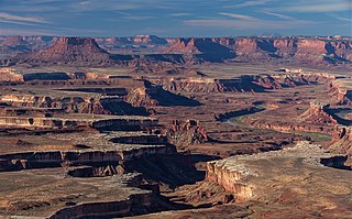
Canyonlands National Park is an American national park located in southeastern Utah near the town of Moab. The park preserves a colorful landscape eroded into numerous canyons, mesas, and buttes by the Colorado River, the Green River, and their respective tributaries. Legislation creating the park was signed into law by President Lyndon B. Johnson on September 12, 1964.

Capitol Reef National Park is an American national park in south-central Utah. The park is approximately 60 miles (100 km) long on its north–south axis and just 6 miles (10 km) wide on average. The park was established in 1971 to preserve 241,904 acres of desert landscape and is open all year, with May through September being the highest visitation months.

Hovenweep National Monument is located on land in southwestern Colorado and southeastern Utah, between Cortez, Colorado and Blanding, Utah on the Cajon Mesa of the Great Sage Plain. Shallow tributaries run through the wide and deep canyons into the San Juan River.
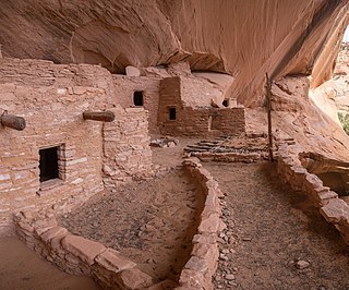
Navajo National Monument is a National Monument located within the northwest portion of the Navajo Nation territory in northern Arizona, which was established to preserve three well-preserved cliff dwellings of the Ancestral Puebloan people: Keet Seel, Betatakin, and Inscription House. The monument is high on the Shonto plateau, overlooking the Tsegi Canyon system, west of Kayenta, Arizona. It features a visitor center with a museum, three short self-guided trails, two small campgrounds, and a picnic area.
Yucca House National Monument is a United States National Monument located in Montezuma County, Colorado between the towns of Towaoc and Cortez, Colorado. Yucca House is a large, unexcavated Ancestral Puebloan archaeological site.

The Utah State Capitol is the house of government for the U.S. state of Utah. The building houses the chambers and offices of the Utah State Legislature, the offices of the Governor, Lieutenant Governor, Attorney General, the State Auditor and their staffs. The capitol is the main building of the Utah State Capitol Complex, which is located on Capitol Hill, overlooking downtown Salt Lake City.

Desert View Watchtower, also known as the Indian Watchtower at Desert View, is a 70-foot (21 m)-high stone building located on the South Rim of the Grand Canyon within Grand Canyon National Park in Arizona, United States. The tower is located at Desert View, more than 20 miles (32 km) to the east of the main developed area at Grand Canyon Village, toward the east entrance to the park. The four-story structure, completed in 1932, was designed by American architect Mary Colter, an employee of the Fred Harvey Company who also created and designed many other buildings in the Grand Canyon vicinity including Hermit's Rest and the Lookout Studio. The interior contains murals by Fred Kabotie.

Chetro Ketl is an Ancestral Puebloan great house and archeological site located in Chaco Culture National Historical Park, New Mexico, United States. Construction on Chetro Ketl began c. 990 and was largely complete by 1075, with significant remodeling occurring in the early and mid-1110s. Following the onset of a severe drought, most Chacoans emigrated from the canyon by 1140; by 1250 Chetro Ketl's last inhabitants had vacated the structure.

Horseshoe Canyon, formerly known as Barrier Canyon, is in a remote area west of the Green River and north of the Canyonlands National Park Maze District in Utah, United States. It is known for its collection of Barrier Canyon Style (BCS) rock art, including both pictographs and petroglyphs, which was first recognized as a unique style here. A portion of Horseshoe Canyon containing The Great Gallery is part of a detached unit of Canyonlands National Park. The Horseshoe Canyon Unit was added to the park in 1971 in an attempt to preserve and protect the rock art found along much of its length.
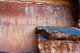
Barrier Canyon Style (BCS) describes a distinctive style of rock art which appears mostly in Utah, with the largest concentration of sites in and around the San Rafael Swell and Canyonlands National Park, but the full range extends into much of the state and western Colorado. The term was first applied by Polly Schaafsma to describe a handful of similar sites known at the time, including several along Barrier Creek in Horseshoe Canyon. Barrier Canyon Style rock art panels are mostly pictographs (painted) but there are also several petroglyphs (pecked) in the style. These panels are believed to have been created during the archaic period and are estimated to be somewhere in the range of 1500 to 4000 years old, possibly older -- clay figurines of a similar style found in Cowboy Cave have been dated to over 7000 years old.
The World At Night (TWAN) is an international project to produce and present a collection of high-quality photos, videos, and virtual reality (VR) images of the night sky taken at various natural, cultural, and historic locations worldwide.
This is a list of the National Register of Historic Places listings in Canyonlands National Park.

The Canyons of the Ancients Visitor Center and Museum located in Dolores, Colorado, is an archaeological museum of Native American pueblo and hunter-gatherer cultures. Two 12th-century archaeological sites, the Escalante and Dominguez Pueblos, at the center were once home to Ancient Pueblo peoples. The museum's permanent and special exhibits display some of the 3 million mostly Ancestral Puebloan artifacts curated at the facility. The center also houses a public research library, educational resources and a museum shop. Wheelchair-accessible facilities include a picnic area and an interpreted nature and cultural trail.

The Pueblo I Period was the first period in which Ancestral Puebloans began living in pueblo structures and realized an evolution in architecture, artistic expression, and water conservation.

The Lagomarsino Petroglyph Site (26ST1) is a 65-acre (26 ha) archeological site of petroglyphs, located in Storey County, Nevada near Virginia City. It was listed for its potential to yield information in the future and includes one contributing site with approximately 2000 items.

The Ancestral Puebloans, also known as the Anasazi, were an ancient Native American culture that spanned the present-day Four Corners region of the United States, comprising southeastern Utah, northeastern Arizona, northwestern New Mexico, and southwestern Colorado. They are believed to have developed, at least in part, from the Oshara tradition, which developed from the Picosa culture. The people and their archaeological culture are often referred to as Anasazi, meaning "ancient enemies", as they were called by Navajo. Contemporary Puebloans object to the use of this term, with some viewing it as derogatory.
Bluff Great House is an Ancestral Puebloan great house and archeological site located in southeastern Utah, United States. The site lies near the north bank of the San Juan River, approximately 130 miles (210 km) northwest of Chaco Culture National Historical Park. It contained between fifty and sixty rooms, with four kivas and a great kiva nearby. Two ancient road segments were found in the area, and several berms were leveled to create a terrace, which is rare in Chacoan sites. The great house was partially excavated from 1996 to 2004, and archeologists believe the site was constructed, in at least two stages, between 1075 and 1150 CE by Chacoans who interacted with the Puebloan residents of both Mesa Verde and Kayenta, Arizona. Bluff Great House was abandoned c. 1250.
East Community is an Ancestral Puebloan great house community and archeological site located 12 miles (19 km) east of Pueblo Bonito, at the eastern end of Chaco Culture National Historical Park, New Mexico, United States. Archeological evidence uncovered during the 1980s suggests the site was occupied by both Chacoans and Mesa Verdeans. Eighty-two structures have been identified in the area, including a great house that contains twenty-five rooms and several small house sites. At least one kiva has been uncovered there, but no great kivas. A partial road segment is visible there, but archeologists are unsure if it connects with a longer segment thought to originate near Pueblo Pintado. The great house at East Community was constructed in the 10th century, with significant additions completed during the 11th century. The associated small house sites were occupied by Chacoans from 875 to 1300, and thirty-nine of them by Mesa Verdeans, from 1175 to 1300. Archeologist Thomas Windes believes the site was linked to Chaco Canyon through a system of signaling stations atop the area's mesas.

