
Pointe Coupee Parish is a parish located in the U.S. state of Louisiana. As of the 2020 census, the population was 20,758. The parish seat is New Roads.

Morganza is an incorporated village near the Mississippi River in Pointe Coupee Parish, Louisiana, United States. The population was 610 at the 2010 census, down from 659 in 2000. It is part of the Baton Rouge Metropolitan Statistical Area. The village's zip code is 70759. The Morganza Spillway, a flood control structure between the Mississippi River and the Atchafalaya Basin, is located nearby.
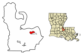
New Roads is a city in and the parish seat of Pointe Coupee Parish, Louisiana, United States. The center of population of Louisiana was located in New Roads in 2000. The population was 4,831 at the 2010 census, down from 4,966 in 2000. The city's ZIP code is 70760. It is part of the Baton Rouge Metropolitan Statistical Area.
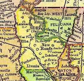
Waterloo is the name of a former town at the upriver juncture of the False River oxbow on the west bank of the Mississippi River in Pointe Coupee Parish, Louisiana, United States. Founded circa 1820, the community grew as a bustling export center for cotton and sugar cane produced in Pointe Coupee Parish.

The Baton Rouge metropolitan statistical area, as defined by the United States Office of Management and Budget, or simply the Baton Rouge metropolitan area or Greater Baton Rouge, is a sprawling metropolitan statistical area surrounding the city of Baton Rouge. Its principal city Baton Rouge is unusual because it has no major incorporated satellite cities, a rarity for a metropolitan area of its size. Including the western edge of the Florida Parishes regions, it is known as "Plantation Country", the "Capital Region", and "The 225". At the 2010 U.S. census, the metropolitan area had a population of 802,484, up from 705,973 in 2000. At the 2020 census, its population increased to 870,569, up from 2020 estimates at 858,571.
Ventress is a census-designated place located in Pointe Coupee Parish, Louisiana, United States, along the northeastern end of the False River. The population of the area is approximately 1,100. It is home to the Hunter Fabre Post 248 American Legion Hall on Legion Road. The zip code is 70783.
Jarreau is an unincorporated community in the 7th Ward of Pointe Coupee Parish, Louisiana, United States. Jarreau is located approximately 30 miles northwest of Baton Rouge, and is a part of the Baton Rouge metropolitan area. The community is located on the banks of False River. It is situated on the southern end of this ox-bow lake, in an area known as "The Island". The community is served by Louisiana Highway 413, known locally as Island Road. The Jarreau Post Office is located on Boulevard D' Isle. Several local businesses were featured in scenes in the Billy Bob Thornton film "The Badge" (2002). The area is also known for fishing and boating with the main publicly accessible boat launch on the southern end of False River being located here.
East Krotz Springs is a ghost town that was located in Pointe Coupee Parish's 1st Ward, approximately 12 miles west of Livonia, Louisiana, United States. The site of the town itself is located at coordinates 30°32'12.87"N, 91°44'24.59"W, and is abandoned. United States Geological Survey maps from 1948 show the town to be located on the east bank of the Atchafalaya River at the mouth of Bayou Sherman, directly across from Krotz Springs, south of the railroad bridge.
Torras is the name of a former town in the extreme northeastern corner of Pointe Coupee Parish, Louisiana, United States. The town was located along either side of the Texas & Pacific Railroad at its juncture with Lower Old River. The Mississippi River is located just to the east and the juncture of the Red and Atchafalaya Rivers just to the west.

Rougon High School was a school located at 13258 Louisiana Highway 416 in the town of Rougon, Louisiana. The school's mascot was the Devils. The school was built in 1940 on land donated by the Rougon family. It was originally called Rougon Graded School, and was partly formed from the students of the old Bueche School located in Jarreau, Louisiana. It was a high school in the Pointe Coupee Parish Public School system until after the 1990–91 school year, when the high school was closed down as part of a plan to combine all parish public schools into the newly formed Pointe Coupee Central High School. The school had been somewhat of a powerhouse in track & field in the 1970s and 1980s. The school won LHSAA state championships in track and field in Class C in 1975, 1976, and 1977. It won Class B state championships in 1985, 1986, 1987, and 1988. The old Rougon High School building, which was built in 1940, is currently the home to Rougon Elementary School.

False River Academy is a nonsectarian private school located in New Roads, Louisiana, in Pointe Coupee Parish. It serves grades Pre-K through 12. The school is independent, and has its own school board. Its enrollment is drawn from Pointe Coupee and surrounding parishes. It is one of two private schools and one of three high schools in the parish.
Dupont is an unincorporated community in southeastern Pointe Coupee Parish, Louisiana, United States. The community is located along Louisiana Highway 413, north of the community of Jarreau. The area falls under the service of the nearby Jarreau Post Office.
False River was an unincorporated community located in southern Pointe Coupee Parish, Louisiana, United States. It was situated near present-day New Roads and the current lake of False River.
Red River Landing was the name of a community located in northern Pointe Coupee Parish, Louisiana, United States. The community was located near the Red River and the Mississippi River, adjacent to the current location of Louisiana State Penitentiary.
Parlange is the name of a community located in southern Pointe Coupee Parish, Louisiana, United States. The community was along Louisiana Highway 1, on the banks of False River.
Point Coupee is the name of an unincorporated community located in Pointe Coupée Parish, Louisiana, United States. It is the home of St. Francis Chapel and is located along Louisiana Highway 420, north of New Roads.
Istrouma Area Council serves Scouts in both Louisiana and Mississippi, primarily in the Greater Baton Rouge Area and Florida Parishes. Specifically, the council includes Scouts from the following parishes: Ascension, East Baton Rouge, West Baton Rouge, East Feliciana, West Feliciana, Iberville, Pointe Coupee, St. Helena, St. James, St. Tammany, Washington, and Tangipahoa. Wilkinson County is the sole Mississippi county in the council.
Raccourci Old River, also called Old River, is a 12-mile (19 km) long ox-bow lake located in northern Pointe Coupee Parish and western West Feliciana Parish in Louisiana, USA. It is also sometimes called Old River creating some confusion with the other Old River. It encompasses approximately 4,000 acres (16 km2).
