
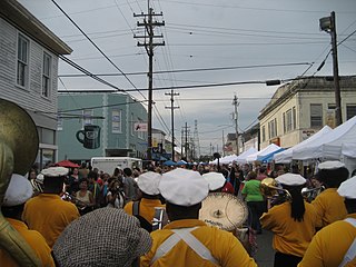
Carrollton is a historic neighborhood of Uptown New Orleans, Louisiana, USA, which includes the Carrollton Historic District, recognized by the Historic District Landmark Commission. It is the part of Uptown New Orleans farthest upriver while still being easily accessible to the French Quarter. It was historically a separate town, laid out in 1833 and incorporated on March 10, 1845. Carrollton was annexed by New Orleans in 1874, but it has long retained some elements of distinct identity.

Tremé is a neighborhood in New Orleans, Louisiana. "Tremé" is often rendered as Treme, and the neighborhood is sometimes called by its more formal French name, the Faubourg Tremé; it is listed in the New Orleans City Planning Districts as Tremé / Lafitte when including the Lafitte Projects.

The Faubourg Marigny is a neighborhood of the city of New Orleans, Louisiana, United States.

The Garden District is a neighborhood of the city of New Orleans, Louisiana, United States. A subdistrict of the Central City/Garden District Area, its boundaries as defined by the New Orleans City Planning Commission are: St. Charles Avenue to the north, 1st Street to the east, Magazine Street to the south, and Toledano Street to the west. The National Historic Landmark district extends a little farther.

Bywater is a neighborhood of the city of New Orleans. A subdistrict of the Bywater District Area, its boundaries as defined by the City Planning Commission are: Florida Avenue to the north, the Industrial Canal to the east, the Mississippi River to the south, and the railroad tracks along Homer Plessy Way to the west. Bywater is part of the Ninth Ward of New Orleans. It includes part or all of Bywater Historic District, which is listed on the National Register of Historic Places.

In New Orleans, Louisiana, United States, downtown has historically referred to neighborhoods along the Mississippi River, downriver from Canal Street – including the French Quarter, Tremé, Faubourg Marigny, Bywater, the 9th Ward, and other neighborhoods. Contrary to the common usage of the term downtown in other cities, this historic application of the term excluded the New Orleans Central Business District. The term continues to be employed as it has been historically, although many younger people and migrants from other parts of the country will use "downtown" as it is used elsewhere; that is, to mean the Central Business District/Warehouse District area.

Uptown is a section of New Orleans, Louisiana, United States, on the east bank of the Mississippi River, encompassing a number of neighborhoods between the French Quarter and the Jefferson Parish line. It remains an area of mixed residential and small commercial properties, with a wealth of 19th-century architecture. It includes part or all of Uptown New Orleans Historic District, which is listed on the National Register of Historic Places.

Central City is a neighborhood of the city of New Orleans. It is located in the 11th Ward of New Orleans in Uptown, just above the Garden District, on the "lakeside" of St. Charles Avenue. A subdistrict of the Central City/Garden District Area, its boundaries as defined by the City Planning Commission are: MLK Boulevard, South Claiborne Avenue and the Pontchartrain Expressway to the north, Magazine, Thalia, Prytania and Felicity Streets and St. Charles Avenue to the south and Toledano Street, Louisiana Avenue and Washington Avenue to the west. This old predominantly African-American neighborhood has been important in the city's brass band and Mardi Gras Indian traditions.

The 16th Ward or Sixteenth Ward is a division of the city of New Orleans, Louisiana, one of the 17 Wards of New Orleans. It is an Uptown ward, along with the adjacent 17th Ward, formerly part of the city of Carrollton, Louisiana which was annexed by New Orleans in the 1870s.

The 10th Ward is a division of the city of New Orleans, Louisiana. The 10th Ward is one of the 17 wards of New Orleans. The ward is one of the city's Uptown wards, formerly the old Faubourg Lafayette annexed by New Orleans in the 1850s.
The city planning commission for New Orleans divided the city into 13 planning districts and 73 distinct neighborhoods in 1980. Although initially in the study 68 neighborhoods were designated, and later increased by the City Planning Commission to 76 in October 2001 based in census data, most planners, neighborhood associations, researchers, and journalists have since widely adopted the 73 as the number and can even trace the number back to the early 1900s. While most of these assigned boundaries match with traditional local designations, some others differ from common traditional use. This is a result of the city planning commission's wish to divide the city into sections for governmental planning and zoning purposes without crossing United States census tract boundaries. While most of the listed names have been in common use by New Orleanians for generations, some designated names are rarely heard outside the planning commission's usage.
The Sliver by the River is a nickname for the area of New Orleans, Louisiana, closest to the Mississippi River, which escaped major flooding after Hurricane Katrina hit the city on August 29, 2005. It exists on higher ground, the natural levee built up by centuries of flooding before there was human settlement. It generally corresponds to the mid-19th-century Crescent City nickname for the city.
Royal Street is a street in the French Quarter of New Orleans, Louisiana, U.S. It is one of the original streets of the city, dating from the early 18th century, and is known today for its antique shops, art galleries, and hotels.

Jean-Bernard Xavier Philippe de Marigny de Mandeville (1785–1868), known as Bernard de Marigny, was a French-Creole American nobleman, playboy, planter, politician, duelist, writer, horse breeder, land developer, and President of the Louisiana State Senate between 1822 and 1823.

Frenchmen Street is in the 7th Ward of New Orleans, Louisiana. It is best known for the three-block section in the Faubourg Marigny neighborhood which since the 1980s has developed as the center of many popular live-music venues, including Cafe Negril, Favela Chic, Vaso, Apple Barrel, Blue Nile, Snug Harbor, the Spotted Cat, and the Maison. In addition the street has numerous restaurants, bars, a premier bicycle shop, a record store, a book shop, and other local businesses.
Leonidas is a neighborhood designation in the city of New Orleans. A subdistrict of the Uptown/Carrollton Area, its boundaries as defined by the New Orleans City Planning Commission are: South Claiborne Avenue, Leonidas and Fig Streets to the north, South Carrollton Avenue to the east, the Mississippi River and Jefferson Parish to the west. Although an official city planning district name, the name "Leonidas" is not widely used nor has it any historical usage and the area is usually referred to by the larger neighborhood "Uptown, or "Carrollton".

St. Roch is a neighborhood of the U.S. city of New Orleans. A subdistrict of the Bywater District Area, its boundaries as defined by the City Planning Commission are: Lafreniere Street, Paris Avenue, I-610, Benefit Street, and Dahlia Walk to the north; People's and Almonaster Avenues to the east; St. Claude Avenue to the south; Elysian Fields Avenue, Hope, Frenchmen, Duels, St. Anthony, Industry, Allen, & Agriculture Streets, A.P. Tureaud Avenue, Abundance, Republic, Treasure, & Dugue Streets, and Florida & St. Bernard Avenues to the west.

Lafayette Square is the second-oldest public park in New Orleans, Louisiana, located in the present-day Central Business District. During the late 18th century, this was part of a residential area called Faubourg Sainte Marie.
The neighborhood of the Faubourg Lafayette is a division in the city of New Orleans, Louisiana. It is a portion of the 10th Ward of New Orleans, and part of Central City, New Orleans. The boundaries are the lake side of St. Charles Avenue from Jackson Avenue to the Pontchartrain Expressway, back to Simon Bolivar Avenue.


