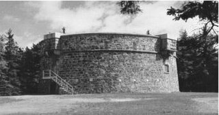
Martello towers, sometimes known simply as Martellos, are small defensive forts that were built across the British Empire during the 19th century, from the time of the French Revolutionary Wars onwards. Most were coastal forts.

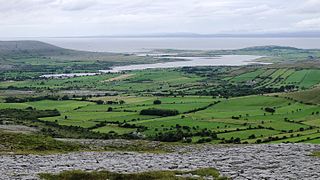
Aughinish is a small island and townland located in Oughtmama Parish of the Barony of Burren in north County Clare, in Ireland on the south shore of Galway Bay. By road it is 10.9 kilometres (6.8 mi) northwest of Kinvarra. The island is approximately two miles (3 km) wide and a mile (1.6 km) from the northernmost tip to the southernmost point and has approximately fifty inhabitants.

Eastbourne Redoubt is a circular coastal defence fort at Eastbourne, East Sussex, on the south coast of England. It was built in 1805 as part of the British anti-invasion preparations during the Napoleonic Wars. The building is now owned by the local authority and is open to the public.

Magilligan is a peninsula that lies in the northwest of County Londonderry, Northern Ireland, at the entrance to Lough Foyle, within Causeway Coast and Glens district. It is an extensive 79,000-acre (32,000-hectare) coastal site, part British army firing range, part nature reserve and is home to the HM Prison Magilligan. The settlement of Magilligan Point on the lough is noted for its ferry crossing to Greencastle, County Donegal.

Fort Grey, colloquially known as the "cup and saucer", is a Martello tower located on a tidal rock in Rocquaine Bay in Saint Peter, Guernsey on the west coast of the island.
Fort Belan is a coastal fortress in North Wales. It is located opposite Abermenai Point, at the south-western end of the Menai Strait, on the coast of Gwynedd, in the parish of Llanwnda. Situated at the tip of the Dinlle Peninsula, the windblown, north-westernmost point of the Welsh mainland, the fort is cut off twice a day by the incoming tide.
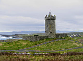
Doonagore Castle is a round 16th-century tower house with a small walled enclosure located about 1 km south of the coastal village of Doolin in County Clare, Ireland. Its name may be derived from Dún na Gabhair, meaning "the fort of the rounded hills" or the "fort of the goats". Doonagore Castle is at present a private holiday home, inaccessible to the public.
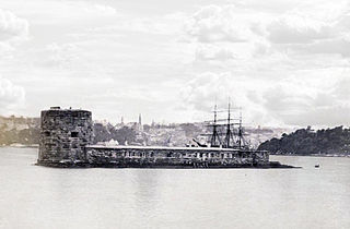
Fort Denison, part of the Sydney Harbour National Park, is a protected national park that is a heritage-listed former penal site and defensive facility occupying a small island located north-east of the Royal Botanic Garden and approximately 1 kilometre (0.62 mi) east of the Opera House in Sydney Harbour, New South Wales, Australia. The island is also known as Mattewanye or Muddawahnyuh in the Eora language, and as Pinchgut Island.
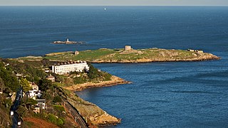
Dalkey Island is an island for which the nearby village of Dalkey is named. It is an uninhabited island located in the Barony of Uppercross, about 16 km (9.9 mi) south of Dublin and 3 km (1.9 mi) south of Dún Laoghaire harbour. An important site of pilgrimage for centuries, it has been known as "St Begnet's Isle" since records began. The earliest reference to 'Dalkey Island' is from c. 1782. The island had a population of 8 in 1841.
Ogonnelloe is a civil parish in east County Clare, Ireland, situated on the R463 regional road between Scariff and Killaloe and in the surrounding hills. It forms part of the Catholic parish of the same name.
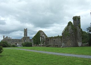
Quin is a village in southeast County Clare, Ireland. It also refers to a civil parish in the barony of Bunratty Upper and to an ecclesiastical parish of the same name in the Catholic Church. The main attraction in the vicinity - Quin Abbey - is open to the public. Although it is mostly ruined, much of the structure remains. The abbey was built on the foundations of an earlier Norman castle; the foundations of three corner towers can still be seen. The village is located in a district sometimes known as Plassey.
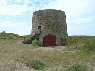
Aughinish Tower is a Martello tower at Aughinish, County Clare, Ireland. It was built as a signal and gun tower to defend Ireland against invasion by the French during the Napoleonic Wars.

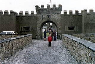
Belvelly is a small village on the northern end of the Great Island of Cork Harbour, about four miles north of the town of Cobh, County Cork, Ireland. Belvelly is situated at the shortest crossing point between Great Island and the neighbouring Fota Island. Belvelly Bridge connects Great Island to Fota Island, which is in turn connected to the mainland near Carrigtwohill.

The Bréhon Tower is accessible only by boat and sits on Bréhon Rock, an island in the Little Russell channel about 1.5 km northeast of St Peter Port, Guernsey, between the port and the islands of Herm and Jethou. Thomas Charles de Putron (1806–1869) built the oval tower of granite from Herm, completing the work in 1857.

Fort Hommet is a fortification on Vazon Bay headland in Castel, Guernsey. It is built on the site of fortifications that date back to 1680, and consists of a Martello tower from 1804, later additions during the Victorian Era, and bunkers and casemates that the Germans constructed during World War II.
Lewis Tower, Jersey, is a Martello tower that the British erected in 1835 in St Ouen's Bay. The tower was named after Colonel Griffith Lewis, who commanded the Royal Engineers in Jersey from December 1830 to January 1836.

Rathborney, sometimes Rathbourney, is a civil parish in the Barony of Burren in County Clare, Ireland.

Dysart and Ruan is a Catholic parish in County Clare, Ireland. It covers the civil parishes of Ruan and Dysert, and includes the village of Ruan, which holds the parish office. The parish contains the ruins of the 12th century St. Tola's Church, part of Dysert O'Dea Monastery.

St. Munchin's Parish is a civil parish that lies partly in County Clare and partly in County Limerick in Ireland, including the center of the city of Limerick. It takes its name from Saint Munchin, the first Bishop of Limerick. According to tradition its church was the first cathedral of the diocese of Limerick, built in 561 AD.
Oughtmama is a civil parish in County Clare. It lies in the Burren, a region in the northwest of the county. It contains many antiquities, including three early-medieval Christian churches, ruined castles, prehistoric cairns and ring forts and two Martello Towers built in the early 19th century.

