Fitzcarrald District

Last updated
Fitzcarrald
District
CountryFlag of Peru.svg  Peru
Region Madre de Dios
Province Manú
Founded December 26, 1912
Capital Boca Manú
Government
   Mayor Walter Misael Mancilla Huaman
Area
  Total 10,955.3 km2 (4,229.9 sq mi)
Elevation 330 m (1,080 ft)
Population (2005 census)
  Total 1,062
  Density 0.097/km2 (0.25/sq mi)
Time zone PET (UTC-5)
UBIGEO 170202

Fitzcarrald District is one of four districts of Manú Province in Peru. [1]

Districts of Peru third level administrative subdivision of Peru

The districts of Peru are the third-level country subdivisions of Peru. They are subdivisions of the provinces, which in turn are subdivisions of the larger regions or departments. There are 1,838 districts in total.

Manú Province Province in Madre de Dios, Peru

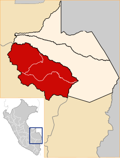
Manú Province is one of three provinces in the Madre de Dios Region of Peru. The capital of Manú province is the city of Salvación.

Peru republic in South America

Peru, officially the Republic of Peru, is a country in western South America. It is bordered in the north by Ecuador and Colombia, in the east by Brazil, in the southeast by Bolivia, in the south by Chile, and in the west by the Pacific Ocean. Peru is a megadiverse country with habitats ranging from the arid plains of the Pacific coastal region in the west to the peaks of the Andes mountains vertically extending from the north to the southeast of the country to the tropical Amazon Basin rainforest in the east with the Amazon river.

Related Research Articles

Edgbaston Waterworks

Edgbaston Waterworks lies to the east of Edgbaston Reservoir, two miles west of the centre of Birmingham, England.

A498 road

The A498 is a 16-mile road between Pen-y-Gwryd and Porthmadog in North Wales.

Moto Kasadera Station railway station in Nagoya, Aichi prefecture, Japan

Moto Kasadera Station is a railway station on the Meitetsu Nagoya Main Line located in Minami-ku, Nagoya, Japan. It is located 58.2 kilometers from the junction of the Nagoya Main Line at Toyohashi.

Moquegua District is one of six districts of the province Mariscal Nieto in Peru.

Tarata District District in Tacna, Peru

Tarata District is one of eight districts of the province Tarata in Peru.

Caminaca District is one of fifteen districts of the province Azángaro in Peru.

Coata District District in Puno, Peru

Coata District is one of fifteen districts of the province Puno in Peru.

Cabanilla District District in Puno, Peru

Cabanilla District is one of ten districts of the province Lampa in Peru.

Pucará District is one of ten districts of the province Lampa in Peru.

Santa Lucía District, Lampa District in Puno, Peru

Santa Lucía District is one of ten districts of the province Lampa in Peru.

Llalli District is one of nine districts of the province Melgar in Peru.

Cuenca District is one of thirty-two districts of the province Huarochirí in Peru.

Huangascar District is one of thirty-three districts of the province Yauyos in Peru.

Madean District is one of thirty-three districts of the province Yauyos in Peru.

Putinza District is one of thirty-three districts of Yauyos Province, Lima Department, Peru. Its capital is San Lorenzo de Putinza and it is the prime apple producer in the Province. Common surnames in this district are: Sandoval, Samaniego, Alcala, Jesusi and Huapaya.

Tauripampa District is one of thirty-three districts of the province Yauyos in Peru.

Toshibetsu Station railway station in Ikeda, Nakagawa district, Hokkaido, Japan

Toshibetsu Station is a train station in Ikeda, Nakagawa District, Hokkaidō, Japan.

The Sécure River is a river of Bolivia.

Bear Creek Township is an inactive township in Montgomery County, in the U.S. state of Missouri.

Speedwell Township is an inactive township in St. Clair County, in the U.S. state of Missouri.

References

Coordinates: 12°56′04″S70°56′01″W / 12.9344°S 70.9336°W / -12.9344; -70.9336

Geographic coordinate system Coordinate system

A geographic coordinate system is a coordinate system that enables every location on Earth to be specified by a set of numbers, letters or symbols. The coordinates are often chosen such that one of the numbers represents a vertical position and two or three of the numbers represent a horizontal position; alternatively, a geographic position may be expressed in a combined three-dimensional Cartesian vector. A common choice of coordinates is latitude, longitude and elevation. To specify a location on a plane requires a map projection.