Sermermiut was an Inuit settlement in the Disko Bay, Greenland. The location is now part of the Ilulissat Icefjord World Heritage Site.

The Madre de Dios River ,is a river shared by Bolivia and Peru which is homonymous to the Peruvian region it runs through. On Bolivian territory it is an affluent to Beni River, close to the town of Riberalta, which later joins with the Mamore River to become the Madeira River after the confluence. The Madeira is a tributary to the Amazon River.
Tambopata can refer to any of the following entities:
Puerto Maldonado is a city in southeastern Peru in the Amazon rainforest 55 kilometres (34 mi) west of the Bolivian border; located at the confluence of the Tambopata and Madre de Dios rivers, the latter of which joins the Madeira River as a tributary of the Amazon. It is the capital of the Madre de Dios Region.

Abel Iturralde is one of the twenty provinces of the Bolivian La Paz Department. It is situated in its northern part. Its name honors Abel Iturralde Palacios, a Bolivian politician. Madidi National Park is partially in this province.

Pisco is a province of the Ica Region in Peru. Its capital is the town of Pisco, where the popular liquor of the same name originated.

Bahuaja-Sonene National Park is a protected area located in the regions of Puno and Madre de Dios, in Peru.

Tambopata National Reserve is a Peruvian nature reserve located in the southeastern region of Madre de Dios. It was established on September 4, 2000, by decree of President Alberto Fujimori. The reserve protects several ecosystems of the tropical rainforest for the preservation of such forest and the sustainable use of forest resources by the peoples around the reserve.
Cañada Rosal is a city located in the province of Seville, Spain. According to the 2005 census (INE), the city has a population of 3085 inhabitants.

Chucuito Province is a province of the Puno Region in Peru. The capital of the province is the city of Juli.

El Collao Province is a province of the Puno Region in Peru, created in 1992. The capital of the province is the city of Ilave.
Zephyr Glacier 1 is a glacier, about 8 miles (13 km) long, flowing westward from the southwest side of Mount Edgell into George VI Sound to the south of Cape Jeremy. The feature was surveyed by Falkland Islands Dependencies Survey (FIDS), 1948, and British Antarctic Survey (BAS), 1971–72; photographed from the air by U.S. Navy, 1966. Named by United Kingdom Antarctic Place-Names Committee (UK-APC) in 1977 after Zephyrus, the west wind. One of several features in this area named after winds.

Juli District is one of seven districts of the Chucuito Province in Puno Region, Peru.
Inambari District is one of four districts of the province Tambopata in Peru.
Laberinto District is one of four districts of the province Tambopata in Peru.
Las Piedras District is one of four districts of the province Tambopata in Peru.
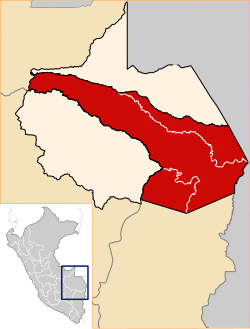
Tambopata District is one of four districts of the Tambopata Province in the Madre de Dios Region in Peru.
Trench Glacier is a deeply entrenched glacier extending along the east coast of Alexander Island, Antarctica, 6 nautical miles (11 km) long and 2 nautical miles (3.7 km) wide, which flows east into the George VI Ice Shelf that occupies George VI Sound immediately south of Mount Athelstan. The mouth of this glacier was first photographed from the air on November 23, 1935, by Lincoln Ellsworth, and it was mapped from these photos by W.L.G. Joerg. Trench Glacier was surveyed in 1948 and 1949 by the Falkland Islands Dependencies Survey, who applied this descriptive name.
Lake Sachavacayoc is a lake in Tambopata National Reserve in Peru. It is located in the Madre de Dios Region, Tambopata Province, Tambopata District. The lake lies in a remote area near the Tambopata River.
This page is based on this
Wikipedia article Text is available under the
CC BY-SA 4.0 license; additional terms may apply.
Images, videos and audio are available under their respective licenses.