Related Research Articles

McClurg is an unincorporated community in extreme northeastern Taney County, Missouri, United States. It is located on Missouri Supplemental Route W, approximately three miles east of Brownbranch or twenty miles (32 km) northeast of Forsyth. McClurg is part of the Branson, Missouri Micropolitan Statistical Area.

Rueter is an extinct town in southeastern Taney County, Missouri. The GNIS classifies it as a populated place. The town site is located at western intersection of U.S. Route 160 and Route 125. Rueter is part of the Branson, Missouri Micropolitan Statistical Area.
Powersite is an unincorporated community in Taney County, Missouri, United States. It is located across Lake Taneycomo from Forsyth on the southeast end of Powersite Dam. The community is part of the Branson, Missouri Micropolitan Statistical Area.

Walnut Shade is an unincorporated community in Taney County, Missouri, United States. It is located approximately six miles northwest of Forsyth on U.S. Route 160. The town sits at the confluence of Bull and Bear Creeks. Walnut Shade is part of the Branson, Missouri Micropolitan Statistical Area.

Kissee Mills is a census-designated place in Taney County, Missouri, United States. It is located on U.S. Route 160, approximately five miles east of Forsyth. Kissee Mills is part of the Branson, Missouri Micropolitan Statistical Area.
Jenkins is an unincorporated community in Barry County, Missouri, United States. It is located on Route 39, just north of Route 248, approximately fourteen miles northeast of Cassville. Mail is delivered via Aurora.
Cedar Creek or Cedarcreek is an unincorporated community in Taney County, Missouri, United States. It is located approximately fifteen miles southeast of Branson at the intersection of Missouri Supplemental Routes M and KK. The stream Cedar Creek lies about three miles north on route M. The community is part of the Branson, Missouri Micropolitan Statistical Area.
Fruitville is an unincorporated community in southeast Howell County, in the U.S. state of Missouri.
Cedar Valley is an extinct town in Taney County, in the U.S. state of Missouri. The townsite was on Long Creek and Big Cedar Hollow just north of the current Missouri Route 86 bridge. The location is currently submerged under the waters of Table Rock Lake.
Day is an unincorporated community in Taney County, in the Ozarks of southern Missouri. Day is located in the northwest part of the county, just south of the Taney-Christian county line on Missouri Route 176 and approximately one mile west of U.S. Route 65.
Dickens is an unincorporated community in north central Taney County, in the U.S. state of Missouri. The community is located on Missouri Route 76, approximately one mile southwest of Taneyville and 4.5 miles northeast of Forsyth.
Eastview is an extinct town in northeastern Taney County, in the Ozarks of southwest Missouri. The location is along a ridge occupied by Farm Road 147 which is a portion of the scenic Glade Top Trail within the Mark Twain National Forest.
Garber is an unincorporated community in western Taney County in the Ozarks of southern Missouri. Garber is located along the Missouri Pacific Railroad line and Roark Creek, approximately four miles northwest of Branson.
McFarland is an extinct town in Taney County, in the U.S. state of Missouri. The community was on Swan Creek approximately two miles north of Forsyth.
Melva is an extinct town in southern Taney County, in the Ozarks of southwest Missouri. The GNIS classifies it as a populated place. The site was located south of Hollister on the east bank of Turkey Creek along the Missouri Pacific Railroad On March, 10 1920, the town was destroyed by a deadly tornado That killed 11 people, many of those only children, Some of the remains of the town still stay there today, However most of it has been cleared out for construction purposes.
Mildred is an unincorporated community in Taney County, in the Ozarks of southern Missouri. Mildred is located on Missouri Route 76, south of Forsyth and east of Kirbyville.
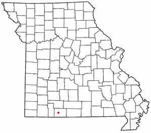
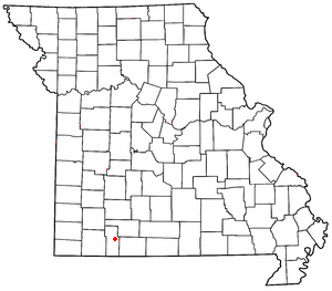
Mincy is an unincorporated community in south-central Taney County, in the Ozarks of southern Missouri, United States. Mincy is located approximately four miles north of the Missouri-Arkansas border and near the upper end of Bull Shoals Lake of the White River. Mincy is the namesake for the Drury-Mincy Conservation Area to the south and east.
Nance is an extinct town in eastern Taney County, in the Ozarks of southwest Missouri. The GNIS classifies it as a populated place. The townsite sits above the east bank of the west fork of Big Creek about one mile north of U.S. Route 160 and about 1.7 miles west of the Taney - Ozark county line. The site is at an elevation of 876 feet.
Ozark Beach is an unincorporated community in Taney County, in the Ozarks of southern Missouri. The site is on the shoreline of Lake Taneycomo, approximately one mile west (upstream) of Powersite Dam.
Swan is an unincorporated community in north central Taney County, in the U.S. state of Missouri. Swan is located on Missouri Route AA, along Blue Creek and approximately 3.5 miles northwest of Taneyville.
References
- ↑ U.S. Geological Survey Geographic Names Information System: Flag (historical)
- ↑ Taney County Post Offices, White River Valley Historical Society, Retrieved 28 September 2020
- ↑ "Post Offices". Jim Forte Postal History. Retrieved 27 December 2016.
- ↑ (16 May 1907). The Kingdom of Taney (Flag entry), Taney County Republican, p. 8, col. 3 ("The school board of the Flag school have engaged Miss Gertie Oliver to teach.")
- ↑ Flag Chapel, Taney County Republican, p. 2 col. 3 (about conversion of old Flag school to a chapel, and moving of school to another location)
- ↑ U.S. Geological Survey Geographic Names Information System: Flag School (historical)
- ↑ "Taney County Place Names, 1928–1945". The State Historical Society of Missouri. Archived from the original on June 24, 2016. Retrieved December 27, 2016.
Municipalities and communities of Taney County, Missouri, United States | ||
|---|---|---|
| Cities |  | |
| Villages | ||
| Townships | ||
| CDP | ||
| Other unincorporated communities | ||
| Ghost towns | ||
| Footnotes | ‡This populated place also has portions in an adjacent county or counties | |
Coordinates: 36°37′26″N93°18′00″W / 36.62389°N 93.30000°W
| This Taney County, Missouri state location article is a stub. You can help Wikipedia by expanding it. |