Flaming Gorge, Utah

Last updated
Flaming Gorge
CDP
Daggett County Utah incorporated and unincorporated areas Flaming Gorge highlighted.svg
Location within Daggett County and the State of Utah
Map of USA UT.svg
Location of Utah in the United States
Coordinates: 40°53′21″N109°28′33″W / 40.88917°N 109.47583°W / 40.88917; -109.47583 Coordinates: 40°53′21″N109°28′33″W / 40.88917°N 109.47583°W / 40.88917; -109.47583
CountryUnited States
State Utah
County Daggett
Named for Flaming Gorge National Recreation Area
Area
[1]
  Total2.289 sq mi (5.93 km2)
  Land2.281 sq mi (5.91 km2)
  Water0.008 sq mi (0.02 km2)
Elevation
[2]
6,919 ft (2,109 m)
Population
 (2010) [3]
  Total83
  Density36/sq mi (14/km2)
Time zone UTC−7 (Mountain (MST))
  Summer (DST) UTC−6 (MDT)
Area code 435
GNIS feature ID2584767 [2]

Flaming Gorge is a census-designated place in Daggett County, Utah, United States. The population was 83 at the 2010 census.

Contents

Demographics

As of the census [3] of 2010, there were 83 people living in the CDP. There were 109 housing units. The racial makeup of the CDP was 97.6% White, 1.2% from some other race, and 1.2% from two or more races. Hispanic or Latino of any race were 4.8% of the population.

Geography

The CDP is located in the Flaming Gorge National Recreation Area, south of Flaming Gorge Reservoir and north of Greendale Junction.

Climate

According to the Köppen Climate Classification system, Flaming Gorge has a warm-summer humid continental climate, abbreviated "Dfb" on climate maps. The hottest temperature recorded in Flaming Gorge was 102 °F (38.9 °C) on July 14, 2002, while the coldest temperature recorded was −38 °F (−38.9 °C) on January 12, 1963. [4]

Climate data for Flaming Gorge, Utah, 1991–2020 normals, extremes 1957–present
MonthJanFebMarAprMayJunJulAugSepOctNovDecYear
Record high °F (°C)60
(16)
66
(19)
76
(24)
82
(28)
93
(34)
100
(38)
102
(39)
99
(37)
99
(37)
84
(29)
75
(24)
64
(18)
102
(39)
Mean maximum °F (°C)50.0
(10.0)
54.3
(12.4)
65.3
(18.5)
73.1
(22.8)
82.3
(27.9)
91.4
(33.0)
95.7
(35.4)
93.8
(34.3)
87.6
(30.9)
77.4
(25.2)
62.6
(17.0)
52.9
(11.6)
96.2
(35.7)
Average high °F (°C)36.6
(2.6)
39.8
(4.3)
49.6
(9.8)
56.7
(13.7)
67.1
(19.5)
79.2
(26.2)
86.8
(30.4)
84.4
(29.1)
75.4
(24.1)
61.5
(16.4)
46.4
(8.0)
36.4
(2.4)
60.0
(15.5)
Daily mean °F (°C)24.8
(−4.0)
27.5
(−2.5)
36.8
(2.7)
43.6
(6.4)
52.6
(11.4)
62.3
(16.8)
69.6
(20.9)
68.0
(20.0)
59.0
(15.0)
46.7
(8.2)
34.3
(1.3)
24.9
(−3.9)
45.8
(7.7)
Average low °F (°C)13.0
(−10.6)
15.1
(−9.4)
24.0
(−4.4)
30.4
(−0.9)
38.1
(3.4)
45.5
(7.5)
52.4
(11.3)
51.7
(10.9)
42.6
(5.9)
32.0
(0.0)
22.1
(−5.5)
13.4
(−10.3)
31.7
(−0.2)
Mean minimum °F (°C)−7.4
(−21.9)
−8.3
(−22.4)
4.3
(−15.4)
14.1
(−9.9)
23.5
(−4.7)
32.2
(0.1)
41.3
(5.2)
39.8
(4.3)
27.6
(−2.4)
14.6
(−9.7)
1.1
(−17.2)
−7.2
(−21.8)
−14.3
(−25.7)
Record low °F (°C)−38
(−39)
−31
(−35)
−14
(−26)
−1
(−18)
14
(−10)
22
(−6)
30
(−1)
26
(−3)
11
(−12)
−4
(−20)
−17
(−27)
−36
(−38)
−38
(−39)
Average precipitation inches (mm)0.49
(12)
0.66
(17)
0.89
(23)
1.10
(28)
1.35
(34)
0.94
(24)
1.04
(26)
1.19
(30)
1.67
(42)
1.37
(35)
0.52
(13)
0.54
(14)
11.76
(298)
Average snowfall inches (cm)8.1
(21)
8.6
(22)
6.6
(17)
3.6
(9.1)
0.6
(1.5)
0.0
(0.0)
0.0
(0.0)
0.0
(0.0)
0.1
(0.25)
2.4
(6.1)
6.3
(16)
7.4
(19)
43.7
(111.95)
Average extreme snow depth inches (mm)6.1
(15)
7.3
(19)
4.2
(11)
1.7
(4.3)
0.5
(1.3)
0.0
(0.0)
0.0
(0.0)
0.0
(0.0)
0.0
(0.0)
1.8
(4.6)
3.1
(7.9)
4.7
(12)
9.7
(25)
Average precipitation days (≥ 0.01 in)4.04.25.76.26.65.35.36.45.65.34.04.262.8
Average snowy days (≥ 0.1 in)3.63.32.91.60.20.00.00.00.11.02.73.418.8
Source 1: NOAA [5]
Source 2: National Weather Service [4]

See also

Related Research Articles

<span class="mw-page-title-main">College, Alaska</span> CDP in Alaska, United States

College is a census-designated place (CDP) in Fairbanks North Star Borough, Alaska, United States. It is part of the Fairbanks, Alaska Metropolitan Statistical Area. As of the 2020 census, the population was 11,332, down from 12,964 in 2010. College is the third-most populated CDP in Alaska.

<span class="mw-page-title-main">Chisana, Alaska</span> CDP in Alaska, United States

Chisana is a census-designated place (CDP) in the Copper River Census Area in the U.S. state of Alaska. As of the 2010 Census, the population of the CDP was 0. The English name Chisana derives from the Ahtna Athabascan name Tsetsaan' Na, meaning literally 'copper river'. The Chisana River joins the Nabesna River just north of Northway Junction, Alaska, to form the Tanana River, a major tributary of the Yukon River. The Chisana Airport consists of a turf and gravel runway which is largely serviced by flights from Tok, Alaska.

<span class="mw-page-title-main">Teec Nos Pos, Arizona</span> Census-designated place in Arizona, United States

Teec Nos Pos is a census-designated place (CDP) in Apache County, Arizona, United States. The population was 507 at the 2020 census. It is the western terminus of U.S. Route 64.

<span class="mw-page-title-main">Stearns, Kentucky</span> CDP in Kentucky, United States

Stearns is a census-designated place (CDP) in McCreary County, Kentucky, United States. The population was 1,586 at the 2000 census. It was founded by Justus Smith Stearns.

<span class="mw-page-title-main">Kingsbury, Nevada</span> CDP in Nevada, United States

Kingsbury is a census-designated place (CDP) in Douglas County, Nevada, United States. The population was 2,152 at the 2010 census.

<span class="mw-page-title-main">Lake Sumner, New Mexico</span> Census-designated place in De Baca County, New Mexico, United States

Lake Sumner is a census-designated place (CDP) in De Baca County, New Mexico, United States. The population was 143 at the 2010 census, up from the figure of 86 recorded in 2000.

<span class="mw-page-title-main">Manila, Utah</span> Town in the state of Utah, United States

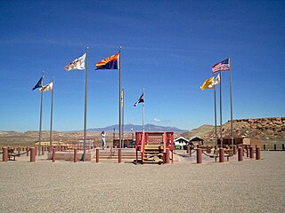
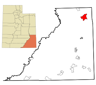
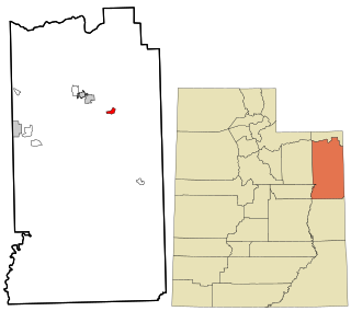
Manila is a small city located on the northern edge of Daggett County, Utah, United States, just south of the Wyoming border. The town is at the junction of State Route 43 and State Route 44, and is the county seat of Daggett County. Nearby sites include the Flaming Gorge National Recreation Area and the Flaming Gorge Reservoir just east of town, and to the south is Ashley National Forest, which includes Kings Peak (13,528 ft), the highest point in Utah.

<span class="mw-page-title-main">Neola, Utah</span> Census-designated place in Utah, United States

Neola is a census-designated place (CDP) in Duchesne County, Utah, United States. The population was 461 at the 2010 census. Neola was established in 1912.

<span class="mw-page-title-main">La Sal, Utah</span> CDP in Utah, United States

La Sal is a census-designated place (CDP) in northeastern San Juan County, Utah, United States. The population was 339 at the 2000 census. The name comes from the La Sal Mountains which means in Spanish "The Salt". The area is known for its uranium resources.

<span class="mw-page-title-main">Bedford, Wyoming</span> Census-designated place in Wyoming, United States

Bedford is a census-designated place (CDP) in Lincoln County, Wyoming, United States. The population was 201 at the 2010 census.

<span class="mw-page-title-main">Fontenelle, Wyoming</span> Census-designated place in Wyoming, United States

Fontenelle is a census-designated place (CDP) in Lincoln County, Wyoming, United States. The population was 13 at the 2010 census.

<span class="mw-page-title-main">Cora, Wyoming</span> CDP in Wyoming, United States

Cora is a census-designated place (CDP) in Sublette County, Wyoming. The population was 114 at the 2020 census.

<span class="mw-page-title-main">Farson, Wyoming</span> CDP in Wyoming, United States

Farson is a census-designated place (CDP) in Sweetwater County, Wyoming, United States. The population was 313 at the 2010 census.

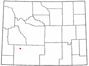
Alta is a census-designated place (CDP) in Teton County, Wyoming, United States. The population was 394 at the 2010 census. It is part of the Jackson, WY–ID Micropolitan Statistical Area, and it is located between Driggs, Idaho and the Grand Targhee ski resort.

<span class="mw-page-title-main">Echo, Utah</span> CDP in Utah, United States

Echo is a census-designated place located in northwestern Summit County, Utah, United States. The population was 56 at the 2010 census.

<span class="mw-page-title-main">Maybell, Colorado</span> Census-designated place in Moffat County, Colorado, United States

Maybell is an unincorporated community and census-designated place (CDP) in and governed by Moffat County, Colorado, United States. The CDP is a part of the Craig, CO Micropolitan Statistical Area.

<span class="mw-page-title-main">Dutch John, Utah</span> Town in the state of Utah, United States

Dutch John is a town located in eastern Daggett County, Utah, United States, approximately 4 miles (6 km) northeast of the Flaming Gorge Dam on U.S. Route 191. The population was 145 at the 2010 census.

<span class="mw-page-title-main">Shell, Wyoming</span> CDP in Wyoming, United States

Shell is a census-designated place (CDP) in Big Horn County, Wyoming, United States. The population was 83 at the 2010 Census.

University is a census-designated place (CDP) and the official name for an area covering a portion of the University of Mississippi campus, in Lafayette County, Mississippi, United States. The CDP is surrounded by the city of Oxford. Its official United States Postal Service designation is "University, Mississippi", with a ZIP Code of 38677.

<span class="mw-page-title-main">Jensen, Utah</span> CDP in Utah, United States

Jensen is a census-designated place in eastern Uintah County, Utah, United States. The population was 412 at the 2010 census. It lies along the Green River and U.S. Route 40, southeast of the city of Vernal, the county seat of Uintah County, and about 17 miles west of the Colorado border. Although Jensen is unincorporated, it has a post office, with the ZIP code of 84035.

References

  1. "2010 Census U.S. Gazetteer File for Places: Utah". Archived from the original on December 13, 2012. Retrieved March 4, 2013.
  2. 1 2 U.S. Geological Survey Geographic Names Information System: Flaming Gorge
  3. 1 2 "American FactFinder". United States Census Bureau. Archived from the original on February 12, 2020. Retrieved July 20, 2012.
  4. 1 2 "NOAA Online Weather Data – NWS Grand Junction". National Weather Service. Retrieved November 5, 2022.
  5. "U.S. Climate Normals Quick Access – Station: Flaming Gorge, UT". National Oceanic and Atmospheric Administration. Retrieved November 5, 2022.

Commons-logo.svg Media related to Flaming Gorge, Utah at Wikimedia Commons