
A levee, dike, dyke, embankment, floodbank or stopbank is an elongated naturally occurring ridge or artificially constructed fill or wall that regulates water levels. It is usually earthen and often parallel to the course of a river in its floodplain or along low-lying coastlines.

A flood is an overflow of water that submerges land that is usually dry. In the sense of "flowing water", the word may also be applied to the inflow of the tide. Floods are an area of study of the discipline hydrology and are of significant concern in agriculture, civil engineering and public health. Human changes to the environment often increase the intensity and frequency of flooding, for example land use changes such as deforestation and removal of wetlands, changes in waterway course or flood controls such as with levees, and larger environmental issues such as climate change and sea level rise.

A floodplain or flood plain or flood-plain is an area of land adjacent to a river which stretches from the banks of its channel to the base of the enclosing valley walls, and which experiences flooding during periods of high discharge. The soils usually consist of clays, silts, sands, and gravels deposited during floods.

Barrier islands are coastal landforms and a type of dune system that are exceptionally flat or lumpy areas of sand that form by wave and tidal action parallel to the mainland coast. They usually occur in chains, consisting of anything from a few islands to more than a dozen. They are subject to change during storms and other action, but absorb energy and protect the coastlines and create areas of protected waters where wetlands may flourish. A barrier chain may extend uninterrupted for over a hundred kilometers, excepting the tidal inlets that separate the islands, the longest and widest being Padre Island of Texas. Sometimes an important inlet may close permanently, transforming an island into a peninsula, thus creating a barrier peninsula. The length and width of barriers and overall morphology of barrier coasts are related to parameters including tidal range, wave energy, sediment supply, sea-level trends, and basement controls. The amount of vegetation on the barrier has a large impact on the height and evolution of the island.

The littoral zone or nearshore is the part of a sea, lake, or river that is close to the shore. In coastal environments, the littoral zone extends from the high water mark, which is rarely inundated, to shoreline areas that are permanently submerged. The littoral zone always includes this intertidal zone, and the terms are often used interchangeably. However, the meaning of littoral zone can extend well beyond the intertidal zone.
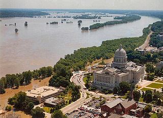
The Great Flood of 1993 was a flood that occurred in the Midwestern United States, along the Mississippi and Missouri rivers and their tributaries, from April to October 1993. The flood was among the most costly and devastating to ever occur in the United States, with $15 billion in damages. The hydrographic basin affected an area approximately 745 miles (1,199 km) in length and 435 miles (700 km) in width, totaling about 320,000 square miles (830,000 km2). Within this zone, the flooded area totaled around 30,000 square miles (78,000 km2) and was the worst such U.S. disaster since the Great Mississippi Flood of 1927, as measured by duration, area inundated, persons displaced, crop and property damage, and number of record river levels. In some categories, the 1993 flood even surpassed the 1927 flood, at the time the largest flood ever recorded on the Mississippi.

Noonday Creek is a 20.2-mile-long (32.5 km) stream in Cobb and Cherokee counties in the U.S. state of Georgia. The stream begins near Kennesaw Mountain and ends at Lake Allatoona.

This article describes severe weather terminology used by the National Weather Service (NWS) in the United States. The NWS, a government agency operating as an arm of the National Oceanic and Atmospheric Administration (NOAA) branch of the United States Department of Commerce (DoC), defines precise meanings for nearly all of its weather terms.
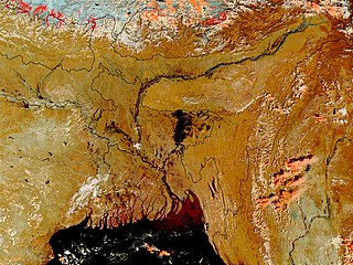
Bangladesh is a land of many rivers. It is very prone to flooding due to being situated on the Brahmaputra River Delta and the many distributaries flowing into the Bay of Bengal. Due to being part of such a basin and being less than 5 metres above mean sea level, Bangladesh faces the cumulative effects of floods due to water flashing from nearby hills, the accumulation of the inflow of water from upstream catchments, and locally heavy rainfall enhanced by drainage congestion. Bangladesh faces this problem almost every year. Coastal flooding, combined with the bursting of river banks is common, and severely affects the landscape and society of Bangladesh. 80% of Bangladesh is [floodplain], and it has an extensive sea coastline, rendering the nation very much at risk of periodic widespread damage. Whilst more permanent defenses, strengthened with reinforced concrete, are being built, many embankments are composed purely of soil and turf and made by local farmers. Flooding normally occurs during the monsoon season from June to September. The convectional rainfall of the monsoon is added to by relief rainfall caused by the Himalayas. Meltwater from the Himalayas is also a significant input.
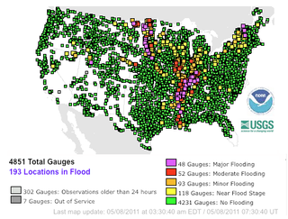
Streamflow, or channel runoff, is the flow of water in streams, rivers, and other channels, and is a major element of the water cycle. It is one component of the runoff of water from the land to waterbodies, the other component being surface runoff. Water flowing in channels comes from surface runoff from adjacent hillslopes, from groundwater flow out of the ground, and from water discharged from pipes. The discharge of water flowing in a channel is measured using stream gauges or can be estimated by the Manning equation. The record of flow over time is called a hydrograph. Flooding occurs when the volume of water exceeds the capacity of the channel.

Johnson Creek is a 25-mile (40 km) tributary of the Willamette River in the Portland metropolitan area of the U.S. state of Oregon. Part of the drainage basin of the Columbia River, its catchment consists of 54 square miles (140 km2) of mostly urban land occupied by about 180,000 people as of 2012. Passing through the cities of Gresham, Portland, and Milwaukie, the creek flows generally west from the foothills of the Cascade Range through sediments deposited by glacial floods on a substrate of basalt. Though polluted, it is free-flowing along its main stem and provides habitat for salmon and other migrating fish.
A flood warning is closely linked to the task of flood forecasting. The distinction between the two is that the outcome of flood forecasting is a set of forecast time-profiles of channel flows or river levels at various locations, while "flood warning" is the task of making use of these forecasts to make decisions about whether warnings of floods should be issued to the general public or whether previous warnings should be rescinded or retracted.

Urban runoff is surface runoff of rainwater created by urbanization. This runoff is a major source of flooding and water pollution in urban communities worldwide.

The Surface Water and Ocean Topography (SWOT) mission is a future satellite altimeter jointly developed by NASA and CNES, the French space agency, in partnership with the Canadian Space Agency (CSA) and UK Space Agency (UKSA). The objectives of the mission are to make the first global survey of the Earth's surface water, to observe the fine details of the ocean surface topography, and to measure how terrestrial surface water bodies change over time. While past satellite missions like the Jason series altimeters have provided variation in river and lake water surface elevations at select locations, SWOT will provide the first truly global observations of changing water levels, slopes, and inundation extents in rivers, lakes, and floodplains. In the world's oceans, SWOT will observe ocean circulation at unprecedented scales of 15-25 km, approximately an order of magnitude finer than current satellites. Because it uses wide-swath altimetry technology, SWOT will almost completely observe the world's oceans and freshwater bodies with repeated high-resolution elevation measurements, allowing observations of variations.
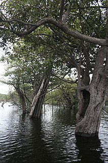
Igapó is a word used in Brazil for blackwater-flooded forests in the Amazon biome. These forests and similar swamp forests are seasonally inundated with freshwater. They typically occur along the lower reaches of rivers and around freshwater lakes. Freshwater swamp forests are found in a range of climate zones, from boreal through temperate and subtropical to tropical. In the Amazon Basin of Brazil, a seasonally whitewater-flooded forest is known as a várzea, which is similar to igapó in many regards; the key difference between the two habitats is in the type of water that floods the forest.
The Mississippi River floods in April and May 2011 were among the largest and most damaging recorded along the U.S. waterway in the past century, comparable in extent to the major floods of 1927 and 1993. In April 2011, two major storm systems deposited record levels of rainfall on the Mississippi River watershed. When that additional water combined with the springtime snowmelt, the river and many of its tributaries began to swell to record levels by the beginning of May. Areas along the Mississippi itself experiencing flooding included Illinois, Missouri, Kentucky, Tennessee, Arkansas, Mississippi, and Louisiana.
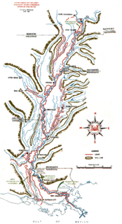
The Mississippi River and its tributaries have flooded on numerous occasions. This is a list of major floods.
A river flood warning is issued by the National Weather Service of the United States when forecast points with formal river gaging sites and established flood stages along rivers, where flooding has already been forecast, is imminent or occurring. The National Weather Service defines river flooding as "the inundation of normally dry areas as a result of increased water levels in an established water course."

Flooding in the Mississippi River Basin during the winter, spring, and summer of 2019 caused at least 12 deaths and economic losses in 19 states totaling in excess of $20 billion. Estimated damages in the Midwestern United States alone had reached $12.5 billion by April 2019. Flood damages totaling $6.2 billion were reported in the 11 states bordering the Mississippi River. In addition to property and crop losses and infrastructure damages, commercial navigation on the Mississippi River was interrupted repeatedly by high currents, low bridge clearances, and closed locks. This delayed shipments of agricultural commodities, adding to the economic stress of crop losses caused by flooding. As of late April 2019, shipments of corn to export terminals in Louisiana were 31% lower than in same period in 2018.

Between May and June 2019, an extended sequence of heavy rainfall events over the South Central United States caused historic flooding along the Arkansas River and its tributaries. Major and record river flooding occurred primarily in northeastern Oklahoma, and the elevated flows continued downstream into Arkansas where the caused additional inundation. Antecedent soil moisture levels and water levels in lakes and streams were already high from previous rains, priming the region for significant runoff and flooding. The prolonged combination of high atmospheric moisture and a sustained weather pattern extending across the continental United States led to frequent high-yield rainfall over the Arkansas River watershed. The overarching weather pattern allowed moisture levels to quickly rebound after each sequential rainfall episode. With soils already saturated, the excess precipitation became surface runoff and flowed into the already elevated lakes and streams. Most rainfall occurred in connection with a series of repeated thunderstorms between May 19–21, which was then followed by additional rains that kept streams within flood stage.
