
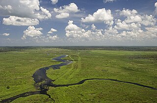
The Everglades is a natural region of tropical wetlands in the southern portion of the U.S. state of Florida, comprising the southern half of a large drainage basin and part of the neotropic ecozone. The system begins near Orlando with the Kissimmee River, which discharges into the vast but shallow Lake Okeechobee. Water leaving the lake in the wet season forms a slow-moving river 60 miles (97 km) wide and over 100 miles (160 km) long, flowing southward across a limestone shelf to Florida Bay at the southern end of the state. The Everglades experience a wide range of weather patterns, from frequent flooding in the wet season to drought in the dry season. The Seminole Tribe gave the large body of water the name Okeechobee meaning "River of Grass" to describe the sawgrass marshes, part of a complex system of interdependent ecosystems that include cypress swamps, the estuarine mangrove forests of the Ten Thousand Islands, tropical hardwood hammocks, pine rockland, and the marine environment of Florida Bay.

The Okefenokee Swamp is a shallow, 438,000-acre (177,000 ha), peat-filled wetland straddling the Georgia–Florida line in the United States. A majority of the swamp is protected by the Okefenokee National Wildlife Refuge and the Okefenokee Wilderness. The Okefenokee Swamp is considered to be one of the Seven Natural Wonders of Georgia. The Okefenokee is the largest "blackwater" swamp in North America.

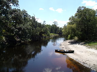
The St. Marys River is a 126-mile-long (203 km) river in the southeastern United States. From near its source in the Okefenokee Swamp, to its mouth at the Atlantic Ocean, it forms a portion of the border between the U.S. states of Georgia and Florida. The river also serves as the southernmost point in the state of Georgia.

Picayune Strand State Forest is one of 37 state forests in Florida managed by the Florida Forest Service. The 78,000-acre forest consists primarily of cypress swamps, wet pine flatwoods and wet prairies. It also features a grid of closed roads over part of it, left over from its previous land development schemes.

The Apalachicola National Forest is the largest U.S. National Forest in the state of Florida. It encompasses 632,890 acres and is the only national forest located in the Florida Panhandle. The National Forest provides water and land-based outdoors activities such as off-road biking, hiking, swimming, boating, hunting, fishing, horse-back riding, and off-road ATV usage.

Tate's Hell State Forest is 202,000 acres (819 km²) of land in Franklin and Liberty counties in Florida. The forest is located near Carrabelle off US 98 along the gulf coast. At one time, Tate's Hell supported at least 12 major habitats including: wet flatwoods, wet prairie, seepage slope, baygall, floodplain forest, floodplain swamp, basin swamp, upland hardwood forest, sandhill, pine ridges, dense titi swamp thickets and scrub. Tate's Hell State Forest is an important hydrologic area and includes a section of the New River. The park's watershed provides fresh water into the Apalachicola Bay, the Carrabelle River and the Ochlockonee River.

Fakahatchee Strand State Preserve is a Florida State Park just west of Copeland, Florida. It is located in the Fakahatchee Strand, a thread of forested strand (swamp) in Big Cypress, a section of the Florida Everglades off SR 29.

The Florida Panther National Wildlife Refuge is part of the United States National Wildlife Refuge System, located in southwestern Florida, twenty miles east of Naples, in the upper segment of the Fakahatchee Strand of the Big Cypress Swamp. It is north of I-75 and west of SR 29.
The Econlockhatchee River is an 87.7-kilometer-long (54.5 mi) north-flowing blackwater tributary of the St. Johns River, the longest river in the U.S. state of Florida. The Econ River flows through Osceola, Orange, and Seminole counties in Central Florida, just east of the Orlando Metropolitan Area. It is a designated Outstanding Florida Waters.

The Wacissa River is a large, spring-fed stream located in south-central Jefferson County, Florida. Its headwaters are located about a mile south of the town of Wacissa, where the river emerges crystal clear from a group of large limestone springs. From its headsprings, the river flows approximately 12 miles (19 km) south through a broad cypress swamp before breaking into numerous braided channels which join the Aucilla River a few miles further south. The river is managed by the Florida Fish & Wildlife Conservation Commission as part of the Aucilla Wildlife Management Area, and has been declared an Outstanding Florida Waterway by the Florida Department of Environmental Protection.

The Asian swamp eel, swamp eel, rice eel, or white ricefield eel is a commercially important, air-breathing species of fish in the family Synbranchidae. Originating in the waters of East and Southeast Asia, it has been identified as an invasive species in the North American Everglades.

Colt Creek State Park is a State Park in Central Florida, 16 miles (26 km) north of Lakeland off of State Road 471. It became open to the public in January 2007. Colt Creek was purchased from the Overstreet family in May 2006. This 5,067 acre park nestled within the Green Swamp Wilderness Area and named after one of the tributaries that flows through the property was opened to the public on January 20, 2007. For over 60 years this property was managed as a cattle ranch by the Overstreet family. Past activities on the land included lime rock mining, timber harvesting, citrus production and turpentining. Composed mainly of pine flatwoods, cypress domes and open pasture land, this piece of pristine wilderness is home to many animal species including the American bald eagle, Sherman's fox squirrel, gopher tortoise, white-tailed deer, wild turkey and bobcat.

The geography and ecology of the Everglades involve the complex elements affecting the natural environment throughout the southern region of the U.S. state of Florida. Before drainage, the Everglades were an interwoven mesh of marshes and prairies covering 4,000 square miles (10,000 km2). The Everglades is simultaneously a vast watershed that has historically extended from Lake Okeechobee 100 miles (160 km) south to Florida Bay, and many interconnected ecosystems within a geographic boundary. It is such a unique meeting of water, land, and climate that the use of either singular or plural to refer to the Everglades is appropriate. When Marjory Stoneman Douglas wrote her definitive description of the region in 1947, she used the metaphor "River of Grass" to explain the blending of water and plant life.
Fisheating Creek is a stream that flows into Lake Okeechobee in Florida. It is the only remaining free-flowing water course feeding into the lake, and the second-largest natural source for the lake. Most of the land surrounding the stream is either publicly owned or under conservation easements restricting development. The lower part of the stream remains in a largely natural state, and efforts are underway to restore the upper part of the stream to a more natural state.
A cypress dome is a type of freshwater forested wetland, or a swamp. They are dominated by the taxodium spp., either the bald cypress, or pond cypress. The name comes from the dome-like shape of treetops, formed by smaller trees growing on the edge where the water is shallow while taller trees grow at the center in deeper water. They usually appear as circular, but if the center is too deep, they can form a “doughnut” shape when viewed from above. Cypress domes are characteristically small compared to other swamps, however they can occur at a range of sizes, dependent on the depth.
A strand swamp or strand is a type of swamp in Florida that forms a linear drainage channel on flatlands. A forested wetland ecological habitat, strands occur on land areas with high water tables where the lack of slope prevents stream formation. Strands are more linear than the cypress dome swamps that form in more rounded depressions and are fairly similar to floodplain swamps that form further north along streams and rivers.

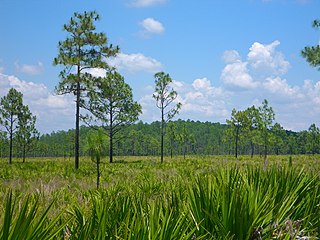
Florida swamps include a variety of wetland habitats. Because of its high water table, substantial rainfall, and often flat geography, the U.S. state of Florida has a proliferation of swamp areas, some of them unique to the state.


