
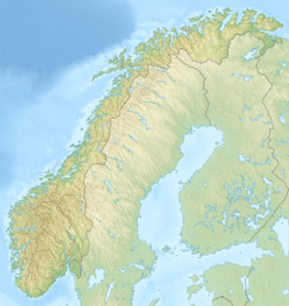
Norway is a country located in Northern Europe in the northern and western parts of the Scandinavian Peninsula. The majority of the country borders water, including the Skagerrak inlet to the south, the North Sea to the southwest, the North Atlantic Ocean to the west, and the Barents Sea to the north. It has a land border with Sweden to the east; to the northeast it has a shorter border with Finland and an even shorter border with Russia.

Kvinnherad is a municipality in Vestland county, Norway. It is located in the traditional district of Sunnhordland, along the Hardangerfjorden. The municipality was the 5th in size in former Hordaland county.

Jondal is a former municipality in the old Hordaland county, Norway. The 247-square-kilometre (95 sq mi) municipality existed from 1863 until its dissolution in 2020 when it became part of Ullensvang Municipality in Vestland county. It was located on the Folgefonna peninsula in the Hardanger district, on the eastern shore of the Hardangerfjorden. The administrative centre of the municipality was the village of Jondal. Other villages in Jondal include Herand, Kysnesstranda, and Torsnes.

Odda is a former municipality in the old Hordaland county, Norway. The municipality existed from 1913 until its dissolution in 2020 when it was merged into Ullensvang Municipality in Vestland county. It was located in southeastern Hordaland county, surrounding the southern end of the Sørfjorden. The administrative centre was the town of Odda, which was also the main commercial and economic centre of the entire Hardanger region. Other villages in the municipality included Botnen, Eitrheim, Håra, Røldal, Seljestad, Skare, and Tyssedal.

The Aletsch Glacier or Great Aletsch Glacier is the largest glacier in the Alps. It has a length of about 23 km (14 mi) (2014), a volume of 15.4 km3 (3.7 cu mi) (2011), and covers about 81.7 km2 (2011) in the eastern Bernese Alps in the Swiss canton of Valais. The Aletsch Glacier is composed of four smaller glaciers converging at Konkordiaplatz, where its thickness was measured by the ETH to be still near 1 km (3,300 ft). It then continues towards the Rhône valley before giving birth to the Massa. The Aletsch Glacier is – like most glaciers in the world today – a retreating glacier. As of 2016, since 1980 it lost 1.3 kilometres (0.81 mi) of its length, since 1870 3.2 kilometres (2.0 mi), and lost also more than 300 metres (980 ft) of its thickness.

The Hardangerfjord is the fifth longest fjord in the world, and the second longest fjord in Norway. It is located in Vestland county in the Hardanger region. The fjord stretches 179 kilometres (111 mi) from the Atlantic Ocean into the mountainous interior of Norway along the Hardangervidda plateau. The innermost point of the fjord reaches the town of Odda.

Rosendal is the administrative centre of the municipality of Kvinnherad in Vestland county, Norway. The village is located on the southern shore of the Hardangerfjorden, about 4 kilometres (2.5 mi) north of the village of Dimmelsvik and about 10 kilometres (6.2 mi) straight west of the vast Folgefonna glacier which sits inside the nearby Folgefonna National Park. The village is especially known for the Barony Rosendal, a historic estate located in the village. Kvinnherad Church is also located in this village.
Svartisen is a collective term for two glaciers located in Nordland county in northern Norway. It is part of Saltfjellet-Svartisen National Park, located in the Saltfjell mountain range. The glaciers are located in the municipalities of Beiarn, Meløy, Rana, and Rødøy. Svartisen consists of two separate glaciers that are separated by the 1-kilometre (0.62 mi) long Vesterdalen valley. The two glaciers are:

Nordre Folgefonna is one of the largest glaciers in mainland Norway. It is the northernmost of the three glaciers that make up Folgefonna. The glacier is located on the Folgefonna peninsula in the Hardanger and Sunnhordland regions of Vestland county. The 26-square-kilometre (10 sq mi) glacier lies in the municipalities of Kvinnherad and Ullensvang. Its highest point is 1,640 m (5,381 ft) above sea level, and its lowest point is 990 m (3,248 ft) above sea level. The glacier lies almost entirely inside Folgefonna National Park.

Folgefonna National Park is a 545.2-square-kilometre (210.5 sq mi) national park in Vestland county, Norway. The park is located on the Folgefonna peninsula, and it spans the municipalities of Kvinnherad, Etne, and Ullensvang. The national park was opened by Queen Sonja on 14 May 2005.

The retreat of glaciers since 1850 is well documented and is one of the effects of climate change. The retreat of mountain glaciers provide evidence for the rise in global temperatures since the late 19th century. Examples include mountain glaciers in western North America, Asia, the Alps in central Europe and tropical and subtropical regions of South America and Africa. Since glacial mass is affected by long-term climatic changes, e.g., precipitation, mean temperature, and cloud cover, glacial mass changes are one of the most sensitive indicators of climate change. Retreat of glaciers is also a major reason for sea level rise. Excluding peripheral glaciers of ice sheets, the total cumulated global glacial losses over the 26-year period from 1993 to 2018 were likely 5500 gigatons, or 210 gigatons per yr.
Blådalsvatnet is a glacial lake in the municipality of Kvinnherad in Vestland county, Norway. The 2.89-square-kilometre (1.12 sq mi) lake lies just outside the Folgefonna National Park, about 10 kilometres (6.2 mi) north of the village of Indre Matre. The lake is formed by the glacial runoff from the large Folgefonna glacier located just north of the lake. The lake is part of the water system used to power the Blåfalli kraftverk hydroelectric power station.
Juklavatnet is a lake on the border of the municipalities of Kvinnherad and Ullensvang in Vestland county, Norway. The 3.61-square-kilometre (1.39 sq mi) lake lies just outside Folgefonna National Park and immediately to the west of the Nordre Folgefonna glacier. The only road access comes from the small village of Nordrepollen in the Mauranger area of Kvinnherad municipality, about 10 kilometres (6.2 mi) south of the lake. There is a dam on the western end of the lake which regulates the depth of the water so that it can be used for hydroelectric power generation. The lake is the largest reservoir that feeds into the Mauranger power station.

Sandvinvatnet is a lake in Ullensvang Municipality in Vestland county, Norway. The 4.3-square-kilometre (1.7 sq mi) lake lies on the southern edge of the town of Odda. The Buardalen valley and Buarbreen glacier lie to the west of the lake. The Norwegian National Road 13 runs along the east side of the lake. The lake water flows north into the short river Opo, before entering the Sørfjorden.

Himachal Pradesh provides water to both the Indus and Ganges basins. The drainage systems of the region are the Chenab, the Ravi, the Beas, the Satluj and the Yamuna. These rivers are perennial and are fed by snow and rainfall. They are protected by an extensive cover of natural vegetation.
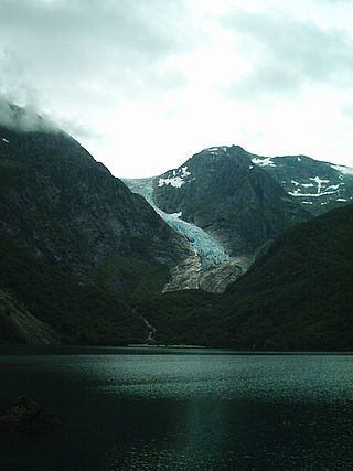
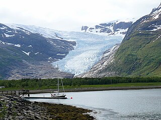
The Bondhusbreen is a glacier in Kvinnherad Municipality in Vestland county, Norway. The glacier is an offshoot of the vast Folgefonna glacier, and it lies inside the Folgefonna National Park. The glacier has a length of around 4 kilometres (2.5 mi) and a height difference of about 1,100 metres (3,600 ft) from its highest to its lowest points.
Midtre Folgefonna is a glacier located in the Hardanger region of Vestland county, Norway. It is one of the three glaciers that make up the large Folgefonna glacier. It is located on the border of Ullensvang and Kvinnherad municipalities between the Nordre Folgefonna and Søndre Folgefonna glaciers on the Folgefonna peninsula. In 1969, the glacier was listed at 13 square kilometres (5.0 sq mi). In a book by glaciologist Olav Orheim from 2009 the area is listed as only 9 square kilometres (3.5 sq mi). The glacier drains partly to the Maurangerfjord to the west, and partly to the Sørfjorden to the east.
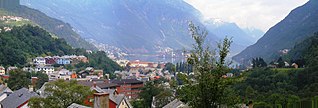
is a town in Ullensvang Municipality in Vestland county, Norway. The town is the administrative centre of the municipality and the largest urban area in the whole Hardanger district. The town is located at the southern end of the Sørfjorden, in a narrow valley between towering mountains and the lake Sandvinvatnet to the south. The large Folgefonna glacier lies just west of Odda, high up in the mountains. The village of Odda was declared a "town" in 2004.
Jondal is a village in Ullensvang Municipality in Vestland county, Norway. It was the administrative centre of the former Jondal municipality prior to its dissolution in 2020. The village is located on the southern shore of the Hardangerfjorden, about 55 kilometres (34 mi) southeast of the city of Bergen. It is located on the Folgefonna peninsula, about 12 kilometres (7.5 mi) northwest of the Folgefonna glacier in Folgefonna National Park. The village of Kysnesstranda lies about 15 kilometres (9.3 mi) to the south.

The Arctic desert ecoregion is a terrestrial ecoregion that covers the island groups of Svalbard, Franz Josef Land, Severny Island and Severnaya Zemlya in the Arctic Ocean, above 75 degrees north latitude. The region is covered with glaciers, snow, and bare rock in a harshly cold environment. The temperature does rise above freezing for short periods in the summer, so some ice melt occurs, and the area supports colonies of sea birds and mammals. It has an area of 161,400 square kilometres (62,300 sq mi).

 Bondhusbreen - an offshoot of Folgefonna
 Looking down from the glacier
 Aerial view of the glaciers
 A closer view of the glacier


