
Sevier County is a county of the U.S. state of Tennessee. As of the 2020 census, the population was 98,380. Its county seat and largest city is Sevierville. Sevier County comprises the Sevierville, TN Micropolitan Statistical Area, which is included in the Knoxville-Morristown-Sevierville, TN Combined Statistical Area.

Blount County is a county located in the East Tennessee Grand Division of the U.S. state of Tennessee. As of the 2020 census, its population was 135,280. The county seat is Maryville, which is also the county's largest city. Blount County is included in the Knoxville metropolitan area.

Gatlinburg is a mountain resort city in Sevier County, Tennessee. It is located 39 miles (63 km) southeast of Knoxville and had a population of 3,944 at the 2010 Census and a U.S. Census population of 3,577 in 2020. It is a popular vacation resort, as it rests on the border of Great Smoky Mountains National Park along U.S. Route 441, which connects to Cherokee, North Carolina, on the southeast side of the national park. Prior to incorporation, the town was known as White Oak Flats, or simply White Oak.
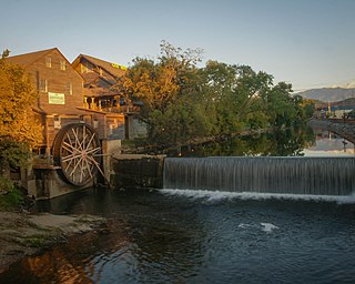
Pigeon Forge is a mountain resort city in Sevier County, Tennessee, United States. As of the 2020 census, the city had a total population of 6,343. Situated just 5 miles (8 km) north of Great Smoky Mountains National Park, Pigeon Forge is a tourist destination that caters primarily to Southern culture and country music fans. The city's attractions include Dollywood and Dollywood's Splash Country, WonderWorks, Alcatraz East Crime Museum, as well as numerous gift shops, outlet malls, amusement rides, and musical theaters.

Great Smoky Mountains National Park is an American national park in the southeastern United States, with parts in North Carolina and Tennessee. The park straddles the ridgeline of the Great Smoky Mountains, part of the Blue Ridge Mountains, which are a division of the larger Appalachian Mountain chain. The park contains some of the highest mountains in eastern North America, including Clingmans Dome, Mount Guyot, and Mount Le Conte. The border between the two states runs northeast to southwest through the center of the park. The Appalachian Trail passes through the center of the park on its route from Georgia to Maine. With 13 million visitors in 2023, the Great Smoky Mountains National Park is the most visited national park in the United States.

The Great Smoky Mountains are a mountain range rising along the Tennessee–North Carolina border in the southeastern United States. They are a subrange of the Appalachian Mountains and form part of the Blue Ridge Physiographic Province. The range is sometimes called the Smoky Mountains, and the name is commonly shortened to the Smokies. The Smokies are best known as the home of the Great Smoky Mountains National Park, which protects most of the range. The park was established in 1934 and, with over 11 million visits per year, is the most visited national park in the United States.
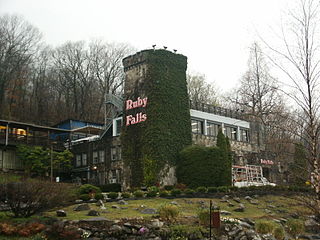
Ruby Falls is a series of underground cascading waterfalls totaling 145 feet (44 m) in Lookout Mountain, near Chattanooga, Tennessee, in the United States.

The Foothills Parkway is a national parkway which traverses the foothills of the northern Great Smoky Mountains in East Tennessee, located in the southeastern United States. The 72.1-mile (114 km) parkway will connect U.S. Route 129 along the Little Tennessee River in the west with Interstate 40 (I-40) along the Pigeon River in the east.
The Great Smoky Mountains Parkway is a highway that travels 23.4 miles (37.7 km) between the Great Smoky Mountains National Park and Interstate 40 (I-40) in Kodak, Tennessee, in East Tennessee. It serves as the main thoroughfare for Gatlinburg, Pigeon Forge, and Sevierville, and includes a 4.3-mile (6.9 km) spur of the Foothills Parkway. It is composed of sections of a number of numbered highways, including U.S. Route 441 (US 441) and US 321 and State Route 66 (SR 66) and SR 448.

The Alum Cave Trail, also known as Alum Cave Bluff Trail, is a hiking trail in the Great Smoky Mountains National Park, in Sevier County, Tennessee. The trail ascends Mount Le Conte, the sixth highest mountain east of the Mississippi River, and passes by many notable landmarks, such as Arch Rock, Inspiration Point, and the Duckhawk Peaks before merging with Rainbow Falls Trail near the summit.
The Trillium Gap Trail is an American hiking trail in the Great Smoky Mountains National Park, in Sevier County, Tennessee. The trail ascends Mount Le Conte, one of the tallest mountains east of the Mississippi River and passes both Grotto Falls and Trillium Gap before reaching the LeConte Lodge, near the summit. The trail to Grotto Falls is one of the busiest in the national park.

The Little River Railroad is a historic class III railroad that operated between Maryville and Elkmont, Tennessee, from 1901 to 1939.

The Sugarlands is a valley in Tennessee within the north-central Great Smoky Mountains, located in the southeastern United States. Formerly home to a string of small Appalachian communities, the valley is now the location of the Great Smoky Mountains National Park headquarters and the Sugarlands Visitor Center. Lying just south of Gatlinburg, the Sugarlands is one of the park's most popular access points.

Roaring Fork is a stream in the Great Smoky Mountains of Tennessee, located in the southeastern United States. Once the site of a small Appalachian community, today the stream's area is home to the Roaring Fork Motor Nature Trail and the Roaring Fork Historic District.
Greenbrier is a valley in the northern Great Smoky Mountains of Tennessee, located in the southeastern United States. Now a recreational area located within the Great Smoky Mountains National Park, Greenbrier was once home to several Appalachian communities.

The Sugarland Mountain Trail is an American hiking trail, in the Great Smoky Mountains National Park of Sevier County, Tennessee. The trail traverses Sugarland Mountain, a massive ridge running perpendicular to the main crest of the Smokies and effectively dividing the park's north-central section from its northwestern section. Sugarland Mountain is flanked by the deep upper valleys of two of the park's major watersheds— the West Fork of the Little Pigeon River and Little River. The trail passes through several forest types, including deciduous forest at lower elevations, heaths ("hells") along the mountain's backbone formations, and a stand of Southern Appalachian spruce-fir forest in the upper elevations. Occasional breaks in the foliage allow for views of Mount Le Conte and Sevier County to the east and Blanket Mountain and the ridges above Elkmont to the west.
WSEV operates as Sevierville, Tennessee's first and only local AM radio station. While other stations are licensed to Sevierville, their studios are based in Knoxville, Tennessee.

U.S. Route 441 (US 441) stretches for 83.28 miles (134.03 km) through the mountains of East Tennessee, connecting Rocky Top with Knoxville, Sevierville, Gatlinburg, and the Great Smoky Mountains National Park, crossing into North Carolina at Newfound Gap. Near its northern terminus, US 441 crosses over Norris Dam and passes through Norris Dam State Park.

Tuckaleechee Caverns is a tourist attraction and the largest and highest rated cave or cavern by AAA east of the Mississippi River. Tuckaleechee runs under the Great Smoky Mountains National Park to Townsend, Tennessee. The caverns were used by Cherokees in the 17th and 18th century, but they were re-discovered in the mid-19th century by sawmill employees in the area. The caverns were opened for tours in 1931 by Earl McCampbell, but the business shut down after one year due to economic impacts of the Great Depression. The caverns were re-opened to the public by Townsend locals Bill Vananda and Harry Myers in 1953. The first tours were taken by kerosene lamps until electricity was wired through the caverns in 1955. The caverns are known for the "Big Room" that could almost fit a football stadium inside it. The "Big Room" is an immense cave/cavern room with many stalagmites reaching 24 feet (7.3 m) tall with flow-stone formations hundreds of feet in length and width. Another large room exists beyond the "Big Room" but is not opened for tours as part of the cavern would have to be destroyed in order to make it accessible to the public. In the 1980s, the Myers sold their shares of the business to the Vanandas, who have operated the caverns since.
English Mountain is a mountain located in the northeastern foothills of the Great Smoky Mountains region of East Tennessee. Rising to a peak of 3,629 feet, it is known for offering scenic fall colors within a convenient drive from Knoxville.

