Columbia City is a neighborhood located in the southeastern part of Seattle, Washington in the Rainier Valley district. It has a landmark-protected historic business district and is one of the few Seattle neighborhoods with a long history of ethnic and income diversity.

Frink Park is a 17.2 acre park in the Leschi neighborhood of Seattle, Washington. It is a heavily wooded hillside and ravine through which flows Frink Creek. Most of the park is bounded by 31st Avenue S. in the west, 34th Avenue S. in the east, and the rights-of-way of S. Main Street in the north and S. King Street in the south. Lake Washington Boulevard S. and S. Frink Place are recreational drives within the park.

Madison Park is a neighborhood in east central Seattle, Washington, USA, named after the city park at the foot of E. Madison Street on the Lake Washington shore. It is bounded on the east by Lake Washington; on the south by the intersection of Lake Washington Boulevard E. and 39th Avenue E., beyond which is Denny-Blaine; on the west by Lake Washington Boulevard E.; and on the north by Union Bay. Washington Park and the private Broadmoor community and golf course are subunits within Madison Park. The neighborhood's main thoroughfares are E. Madison Street and McGilvra Boulevard E..
The Metropolitan Tract is an area of land in downtown Seattle owned by the University of Washington. Originally covering 10 acres (40,000 2), the 1962 purchase of land for a garage for the Olympic Hotel expanded the plot to 11 acres (45,000 m2). The Metropolitan Tract is primarily located in a rectangle formed by Seneca St., Third Ave., Union St., and Sixth Ave.

Squire Park is a neighborhood in the city of Seattle, in the U.S. state of Washington. According to the Squire Park Community Council, it is bounded on the south by S. Jackson Street, on the west by 12th Avenue and 12th Avenue S., on the north by E. Union Street, and on the east by 23rd Avenue and 23rd Avenue S., placing it within the Central District. Its main thoroughfares are E. Jefferson and Cherry Streets and E. Yesler Way and 14th Avenue. Swedish Medical Center's Cherry Hill campus is located here, Seattle University, a Jesuit University has part of its campus in Squire Park, as the Admissions, some dormitories and Athletics departments are east of 12th Avenue.

The Old Man House was the largest winter longhouse in what is now the U.S. state of Washington, once standing on the shore of Puget Sound. It was the center of the Suquamish village of dxʷsəq̓ʷəb on Agate Pass, just south of the present-day town of Suquamish. At one time, it was home to the famous Suquamish chiefs Kitsap and Seattle.

The Hilltop Neighborhood is a historically diverse neighborhood in the Tacoma, Washington Central District.

The Agate Pass Bridge is a structural steel truss cantilever bridge spanning Agate Pass, connecting Bainbridge Island to the Kitsap Peninsula. It was built in 1950, and it replaced a car ferry service which dated from the 1920s. The bridge provides a direct route along Washington State Route 305 between Seattle, via the Seattle-Bainbridge Island ferry, and the Kitsap Peninsula.


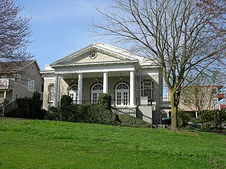
The former Fifth Church of Christ, Scientist, located at 3515 South Alaska Street in the Columbia City neighborhood in the Rainier Valley area of Seattle, Washington, is an historic Christian Science church edifice, whose original entrance was on 36th Avenue. South. Built in 1921. was designed by Earl A. Roberts in the Greek Revival and Neo-Palladian styles. It is a contributing property in the Columbia City Historic District, which was added to the National Register of Historic Places on September 8, 1980. Fifth Church is no longer in existence. The building is now the Rainier Arts Center. The only major exterior change made by the center was the relocation of the front entrance to Alaska Street.

The U.S. Department of Agriculture Administration Building, also known as the Jamie L. Whitten Building, houses the administrative offices of the U.S. Department of Agriculture in Washington, D.C. The Administration Building projects into the National Mall from the larger U.S. Department of Agriculture South Building, and is the only building on the Mall that is not intended for use by the general public. It was the first large Beaux-Arts style building in Washington and set the prototype for the later buildings of the Federal Triangle. The east and west wings were the first Federal office buildings to be built of reinforced concrete. The Whitten Building was listed on the National Register of Historic Places in 1974.

The Hart–Dole–Inouye Federal Center, formerly the Battle Creek Federal Center, is a complex of federal buildings located in Battle Creek, Michigan.

The Pierre P. Ferry House (1903–1906) is a historic home in Seattle, Washington, United States.
The William E. Boeing House is a historic mansion located in the gated community of The Highlands in Shoreline, Washington.
Glencove is an unincorporated community in Pierce County, in the U.S. state of Washington.

Julian Franklin Everett was an American architect known for the buildings he designed in Seattle, Washington. His work includes a synagogue for the Temple de Hirsch congregation (1908) and the Pioneer Square Comfort Station and Pergola in Seattle (1909), now a historic landmark. Some of his works, including the temple and a building for Pathé Exchange, were later demolished, while others are listed on the National Register of Historic Places (NRHP).

Pioneer Hall is an historic building in the Madison Park neighborhood of Seattle, in the U.S. state of Washington. The building is listed on the National Register of Historic Places.

The YWCA Building is a historic building in Seattle, in the U.S. state of Washington. The structure is listed on the National Register of Historic Places and has been designated a Seattle landmark.

