
The John Muir Trail (JMT) is a long-distance trail in the Sierra Nevada mountain range of California, passing through Yosemite, Kings Canyon and Sequoia National Parks. It is named after John Muir, a naturalist.

Kings Canyon National Park is an American national park in the southern Sierra Nevada, in Fresno and Tulare Counties, California. Originally established in 1890 as General Grant National Park, the park was greatly expanded and renamed on March 4, 1940. The park's namesake, Kings Canyon, is a rugged glacier-carved valley more than a mile (1,600 m) deep. Other natural features include multiple 14,000-foot (4,300 m) peaks, high mountain meadows, swift-flowing rivers, and some of the world's largest stands of giant sequoia trees. Kings Canyon is north of and contiguous with Sequoia National Park, and both parks are jointly administered by the National Park Service as the Sequoia and Kings Canyon National Parks.

The John Muir Wilderness is a wilderness area that extends along the crest of the Sierra Nevada of California for 90 miles (140 km), in the Inyo and Sierra National Forests. Established in 1964 by the Wilderness Act and named for naturalist John Muir, it encompasses 652,793 acres (2,641.76 km2). The wilderness lies along the eastern escarpment of the Sierra from near Mammoth Lakes and Devils Postpile National Monument in the north, to Cottonwood Pass near Mount Whitney in the south. The wilderness area also spans the Sierra crest north of Kings Canyon National Park, and extends on the west side of the park down to the Monarch Wilderness.

The South Fork Kern River is a tributary of the Kern River in the Sierra Nevada of the U.S. state of California. It is one of the southernmost rivers on the western slope of the mountains, and drains a high, relatively dry plateau country of 982 square miles (2,540 km2) along the Sierra Crest. The upper South Fork flows through a series of rugged canyons, but it also drains a flat, marshy valley before joining the Kern River at Lake Isabella.

The Golden Trout Wilderness is a federally designated wilderness area in the Sierra Nevada, in Tulare County and Inyo County, California. It is located 40 miles (64 km) east of Porterville within Inyo National Forest and Sequoia National Forest.

The South Fork Kings River is a 44.1-mile (71.0 km) tributary of the Kings River in the Sierra Nevada of Fresno County, California. The river forms part of Kings Canyon, the namesake of Kings Canyon National Park and one of the deepest canyons in North America with a maximum relief of 8,200 feet (2,500 m) from rim to river.
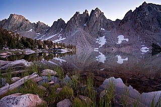
Kearsarge Pinnacles is a linear series of 12 pillars and crags on a northwest–southeast trending ridge located one mile west of the crest of the Sierra Nevada mountain range, in the southeast corner of Fresno County, in northern California. It is situated in Kings Canyon National Park, 11 miles (18 km) west-southwest of the community of Independence, immediately southwest of the Kearsarge Lakes and Kearsarge Pass, and northwest of parent University Peak. The highest, number 4, rises to 12,008 feet in elevation, whereas number 8 is the most prominent. Topographic relief is significant as the west aspect rises 2,500 feet above Vidette Meadow in one-half mile. The John Muir Trail traverses below the west aspect of this remote geographical feature. The Kearsarge pinnacles, lakes, peak, and pass were named after the Kearsarge mine to the east, which was named by its owners after the USS Kearsarge. In turn, the ship was named after Mount Kearsarge in New Hampshire.

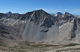
Black Mountain is a 13,291-foot-elevation (4,051-meter) mountain summit located on the crest of the Sierra Nevada mountain range in northern California. It is situated on the common border of Fresno County with Inyo County, as well as the shared boundary of John Muir Wilderness and Kings Canyon National Park. It is 10.5 miles (16.9 km) west of the community of Independence, and 4.3 miles (6.9 km) north-northwest of parent University Peak. Black Mountain ranks as the 91st highest summit in California. Topographic relief is significant as the west aspect rises 2,750 feet above Rae Lakes in approximately one mile. The John Muir Trail traverses below the west aspect of this peak, providing an approach to the mountain. The first ascent of the summit was made in 1905 by George R. Davis, a USGS topographer. This mountain is habitat for the endangered Sierra Nevada bighorn sheep, which restricts climbing from July through December, so most ascents are made in the spring.
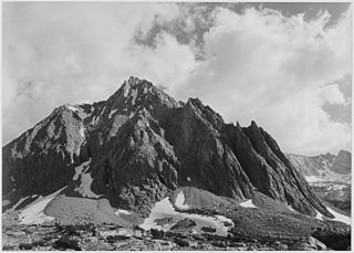
Colosseum Mountain is a 12,473-foot-elevation double summit mountain located on the crest of the Sierra Nevada mountain range in northern California. It is situated on the common border of Fresno County with Inyo County, as well as the shared boundary of John Muir Wilderness and Kings Canyon National Park. It is 12 miles (19 km) northwest of the community of Independence, 1.2 miles (1.9 km) east of Mount Cedric Wright, 2.6 miles (4.2 km) west of Sawmill Point, and 1.6 miles (2.6 km) south-southeast of Mount Perkins, the nearest higher neighbor. The lower east summit is 12,451-feet in elevation and marked as Colosseum Mountain on maps, but the 12,473-foot west summit is higher. Approximately 1,000 feet distance separate the two summits. The John Muir Trail passes to the west of this peak, providing an approach to the mountain. The first ascent of the summit was made August 5, 1922, by Chester Versteeg, a prominent Sierra Club member, via the southwest face.
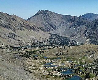
Center Peak is a 12,760-foot-elevation (3,890-meter) mountain summit located one mile west of the crest of the Sierra Nevada mountain range, in the northeast corner of Tulare County in northern California. It is situated in eastern Kings Canyon National Park, 11 miles (18 km) southwest of the community of Independence, 1.8 miles (2.9 km) south of University Peak, and two miles north of Forester Pass. Topographic relief is significant as the north aspect rises 2,230 feet above Bubbs Creek in one mile. The John Muir Trail which traverses below the west slope of this remote peak provides an approach.

Cirque Peak is a 12,900-foot-elevation (3,900-meter) mountain summit located on the crest of the Sierra Nevada mountain range in California. It is situated on the common border of Tulare County with Inyo County, as well as the shared boundary of Golden Trout Wilderness and John Muir Wilderness, on land managed by Inyo National Forest. It is 14 miles (23 km) southwest of the community of Lone Pine, 7.7 miles (12.4 km) south-southeast of Mount Whitney, and 3.2 miles (5.1 km) south of Mount Langley, the nearest higher neighbor. Cirque Peak is the highest point of the Golden Trout Wilderness, and ranks as the 175th highest peak in California. Topographic relief is significant as it rises 1,800 feet above Cirque Lake in approximately one mile. The Pacific Crest Trail traverses the southwest slope of this mountain, providing an approach option. The mountain was apparently named in 1890 by Joseph Nisbet LeConte and companions who noted the remarkable cirque on the north aspect.

Mount Bago is an 11,870-foot-elevation (3,620-meter) mountain summit located west of the crest of the Sierra Nevada mountain range, in the southeast corner of Fresno County, in northern California. It is situated in Kings Canyon National Park, 14 miles (23 km) west of the community of Independence, 2.3 miles west of the Kearsarge Pinnacles, and 2.4 miles southwest of Mount Rixford. Topographic relief is significant as the south aspect rises 3,675 feet above Junction Meadow in one mile. The John Muir Trail passes to the northeast of this remote geographical feature. The first ascent of the summit was made July 11, 1896, by Joseph Nisbet LeConte and Wilson S. Gould.

Disappointment Peak is a 13,917-foot-elevation summit located on the shared boundary of Fresno County and Inyo County in California, United States.

Mount Starr, elevation 12,835 feet (3,912 m), is a mountain summit located on the crest of the Sierra Nevada mountain range in northern California, United States. It is situated in the John Muir Wilderness on the common boundary shared by Sierra National Forest with Inyo National Forest, and along the common border of Fresno County with Inyo County. It is bound on the east by Little Lakes Valley, and is 0.8 mile northeast of Mono Pass. Topographic relief is significant as the summit rises 2,300 feet above Little Lakes Valley in approximately one-half mile (0.80 km). Neighbors include Mount Abbot, three miles to the south-southwest, Mount Morgan, 2.5 miles to the southeast, and Pointless Peak is 2.5 miles to the north.
Mount Julius Caesar is a 13,213-foot-elevation mountain summit located on the crest of the Sierra Nevada mountain range in northern California, United States. It is situated in the John Muir Wilderness on the boundary that Sierra National Forest shares with Inyo National Forest, and along the common border shared by Fresno County with Inyo County. It is one mile southwest of line parent Bear Creek Spire, and 22 miles (35 km) west of the community of Bishop. Italy Pass is one-half mile immediately south of the summit, and Granite Park lies to the southeast. Mount Julius Caesar ranks as the 106th-highest summit in California. Topographic relief is significant as the summit rises 2,000 feet above Lake Italy in 0.7 miles (1.1 km).

Mount Prater is a 13,471-foot-elevation (4,106 meter) mountain summit located on the shared border of Fresno County and Inyo County in California, United States.

Mount Jepson is a 13,390-foot-elevation (4,081 meter) summit located on the shared boundary of Fresno County and Inyo County in California, United States.

Mather Pass is a high mountain pass in the U.S. state of California's Sierra Nevada mountain range. It lies within far eastern Fresno County, inside Kings Canyon National Park and the Sequoia-Kings Canyon Wilderness. The pass lies at an elevation of 12,068 feet, separating Palisade Basin to the north and Upper Basin to the south.

Pinchot Pass is a high mountain pass in the Sierra Nevada mountain range of California, in the United States. It lies within far eastern Fresno County, inside Kings Canyon National Park and the Sequoia-Kings Canyon Wilderness.


