Related Research Articles
Westmoreland County is a county in the Commonwealth of Pennsylvania, United States. As of the 2020 census, the population was 364,663. The county seat is Greensburg and the most populous community is Hempfield Township. It is named after Westmorland, a historic county of England.

Bell Township is a township in Westmoreland County, Pennsylvania, United States. The population was 2,080 at the 2020 decennial census.

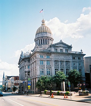
Greensburg is a city in and the county seat of Westmoreland County, Pennsylvania, United States. The population was 14,976 at the 2020 census. The city lies within the Laurel Highlands and the ecoregion of the Western Allegheny Plateau and is a part of the Pittsburgh metropolitan area. The city is named after Nathanael Greene, a major general of the Continental Army in the American Revolutionary War.
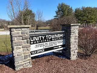
Unity Township is a township in Westmoreland County, Pennsylvania, United States. The population was 21,724 at the 2020 census, a decline of approximately 4% compared to the 2010 census.

Lord Dunmore's War, also known as Dunmore's War, was a brief conflict in fall 1774 between the British Colony of Virginia and the Shawnee and Mingo in the trans-Appalachian region of the colony south of the Ohio River. Broadly, the war included events between May and October 1774. The governor of Virginia during the conflict was John Murray, 4th Earl of Dunmore, who in May 1774, asked the House of Burgesses to declare a state of war with the Indians and call out the Virginia militia.
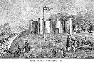
Fort Henry was a colonial fort which stood about ¼ mile from the Ohio River in what is now downtown, Wheeling, West Virginia. The fort was originally known as Fort Fincastle and was named for Viscount Fincastle, Lord Dunmore, Royal Governor of Virginia. Later it was renamed for Patrick Henry, and was at the time located in Virginia. The fort was subject to two major sieges, two notable feats and other skirmishes.

William Crawford was an American military officer and surveyor who worked as a land agent for George Washington. Crawford fought in the French and Indian War and the American Revolutionary War. He was tortured and burned at the stake by American Indians during the Crawford expedition in retaliation for the Gnadenhutten massacre, which saw 96 Christian Munsee massacred by the Pennsylvania Militia on March 8, 1782.
John Hardin was an American soldier, scout, and frontiersman. As a young man, he fought in Lord Dunmore's War, in which he was wounded, and gained a reputation as a marksman and "Indian killer." He served in the Continental Army during the American Revolutionary War, where he played a noteworthy role in the American victory at Saratoga in 1777. After the war, he moved to Kentucky, where he fought against Native Americans in the Northwest Indian War. In 1790, he led a detachment of Kentucky militia in a disastrous defeat known as "Hardin's Defeat." In 1792, he was killed while serving as an emissary to the Natives in the Northwest Territory.
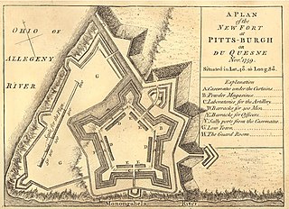
Fort Pitt was a fort built by British forces between 1759 and 1761 during the French and Indian War at the confluence of the Monongahela and Allegheny rivers, where the Ohio River is formed in western Pennsylvania. It was near the site of Fort Duquesne, a French colonial fort built in 1754 as tensions increased between Great Britain and France in both Europe and North America. The French destroyed Fort Duquesne in 1758 when they retreated under British attack.

The District of West Augusta was a short-lived (1774–76) historical region of Colonial Virginia that encompassed much of what is now northern West Virginia and southwestern Pennsylvania.
Hannastown is an unincorporated community and important historical and archaeological site located in Hempfield Township, Westmoreland County, Pennsylvania, United States. Although the village is not tracked by the Census Bureau, it has been assigned the ZIP code 15635.

Christ Church is an Episcopal church in the Old City neighborhood of Philadelphia. Founded in 1695 as a parish of the Church of England, it played an integral role in the founding of the Protestant Episcopal Church in the United States. In 1785, its rector, William White, became the first Presiding Bishop of the Episcopal Church.

Fort Pitt Museum is an indoor/outdoor museum that is administered by the Senator John Heinz History Center in downtown Pittsburgh, Allegheny County, Pennsylvania in the United States. It is at the confluence of the Monongahela and Allegheny Rivers, where the Ohio River is formed. Fort Pitt Museum is surrounded by Point State Park, a Pennsylvania state park named for the geographically and historically significant point that is between the rivers. This piece of land was key to controlling the upper reaches of the Ohio River Valley and western Pennsylvania, before, during and after the French and Indian War as well as the American Revolution.
Ruffs Dale, also spelled Ruffsdale, is an unincorporated community in East Huntingdon Township, Westmoreland County, Pennsylvania United States. It is located approximately forty miles from Pittsburgh. Ruffs Dale has its own post office, with zip code 15679, located at 875 State Route 31.
Manada Gap is an unincorporated community in East Hanover Township, Dauphin County, Pennsylvania, United States, located in the Harrisburg-Carlisle area, near Fort Indiantown Gap.
Boquet is an unincorporated community in Penn Township, Westmoreland County, Pennsylvania, United States.

Heinrich Zeller House, also known as Fort Zeller and Zeller's Fort, is a historic 1+1⁄2-story building that has served as a fort, block house and residence. The historic structure is located in Millcreek Township, Lebanon County, Pennsylvania.
Mammoth is a census-designated place that is located in Mount Pleasant Township, Westmoreland County in the state of Pennsylvania, United States, with its own post office and postal zip code: 15664.

In 1755, during the French and Indian War, marauding Indians allied with the French attacked European settlers along the Blue Mountains of Pennsylvania. Several of these attacks occurred near the Swatara Gap area. Peter Hedrick and other Swatara Gap area settlers fortified Hedrick's farmstead by building a log-walled stockade around the structure. This was the beginning of Fort Swatara. On January 25, 1756, Captain Frederick Smith and a company of 50 militiamen received orders from Robert Hunter Morris, deputy governor of Colonial Pennsylvania, to take posts at Swatara Gap. Capt. Smith's orders were to occupy the existing fortification at Hedrick's farmstead and reinforce it if necessary. Smith's troops erected a military-style log blockhouse and magazine shed for ammunition storage and surrounded the structures with a sturdy log stockade.
References
- ↑ Rupp, Israel Daniel. Early History of Western Pennsylvania, and of the West, and of Western Expeditions and Campaigns, from MDCCLIV to MDCCCXXXIII , p. 119 (footnote 2). Pittsburgh and Harrisburg, Pennsylvania: Daniel W. Kauffman and William O. Hickock, 1846.
- ↑ "Fort Allen" and "Fort Allen Plaque," in "Pennsylvania Historical Marker Search." Harrisburg, Pennsylvania: Pennsylvania Historical and Museum Commission, retrieved online September 7, 2019.
- ↑ Rupp, p. 119.
- ↑ Rupp, pp. 259-260.
- ↑ Rupp, p. 119.
- ↑ "Fort Allen" and "Fort Allen Plaque," in "Pennsylvania Historical Marker Search," Pennsylvania Historical and Museum Commission.
- ↑ "Fort Allen - Plaque -". Waymarking.com. 2012. Retrieved August 8, 2012.
- ↑ "Fort Allen" and "Fort Allen Plaque," in "Pennsylvania Historical Marker Search," Pennsylvania Historical and Museum Commission.