
New Tavern Fort is an historic artillery fort in Gravesend, Kent. Dating mostly from the 18th and 19th centuries, it is an unusually well-preserved example of an 18th-century fortification and remained in use for defensive purposes until the Second World War. It was built during the American War of Independence to guard the Thames against French and Spanish raiders operating in support of the newly formed United States of America. It was redesigned and rebuilt in the mid-19th century to defend against a new generation of iron-clad French warships.

The Needles Batteries are two military batteries built above the Needles stacks to guard the West end of the Solent. The field of fire was from approximately West South West clockwise to Northeast and they were designed to defend against enemy ships.

Several boards have been appointed by US presidents or Congress to evaluate the US defensive fortifications, primarily coastal defenses near strategically important harbors on the US shores, its territories, and its protectorates.
Lavernock Battery was built at Lavernock Point, Wales on the recommendations of the 1860 Royal Commission during the late 1860s to protect the ports of the Severn Estuary. It was replaced by a new anti-aircraft battery during World War II that was equipped with four heavy anti-aircraft guns.

York Redoubt is a redoubt situated on a bluff overlooking the entrance to Halifax Harbour at Ferguson's Cove, Nova Scotia, Canada, originally constructed in 1793. It was designated a National Historic Site of Canada in 1962.

Bare Island is a heritage-listed islet located in the Eastern Suburbs of Sydney, in La Perouse in the City of Randwick local government area in the state of New South Wales, in eastern Australia. The islet is located about 16 kilometres (9.9 mi) south east of the Sydney central business district, within Botany Bay, close to the bay's northern headland. Containing former fortification facilities, Bare Island was a former war veterans' home and museum and is now a historic site that was added to the New South Wales State Heritage Register on 2 April 1999 and is significant as an almost completely intact example of late nineteenth century coastal defence technology. It was designed by Sir Peter Scratchley, Gustave Morell and James Barnet and built from 1881 to 1889 by John McLeod on behalf of the NSW Department of Public Works.

The Lower Georges Heights Commanding Position is located in the urban locality of Georges Heights in the suburb of Mosman, on the shores of Port Jackson, Sydney, New South Wales, Australia. The Lower Georges Heights Commanding Position was constructed and designed to stop enemy ships from entering into Sydney Harbour, and worked in conjunction with several others forts located within close proximity.
The Ben Buckler Gun Battery is a heritage-listed fortified former gun emplacement and military installation of the late-Victorian period and now public open space located in the North Bondi locality of Ben Buckler, in the Sydney, Australia. The gun battery was designed by NSW Colonial Government and built during 1893. It is also known as Ben Buckler Gun Battery 1893, 9.2 Disappearing Gun and Bondi Battery. The property is owned by Waverley Municipal Council. It was added to the New South Wales State Heritage Register on 15 December 2006.

Malabar Battery was a coastal defence battery built in 1943 during World War II at Malabar Headland in Sydney, Australia. The battery is also known as Boora Point Battery.

The Steele Point Battery is a small fort, on the shores of Port Jackson in the eastern Sydney suburb of Vaucluse, Australia.
The Henry Head Battery is an artillery battery located on the northern side of the entrance to Botany Bay at Henry Head, La Perouse, New South Wales, Australia.
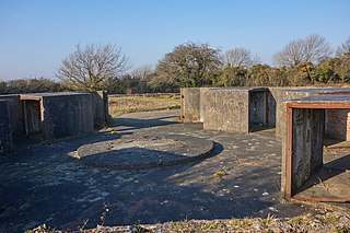
Warden Point Battery is a battery on the Isle of Wight begun in 1862, that was originally armed with 7-inch and 9-inch rifled muzzle loaders on barbette mountings.

Fort Nepean is a former defensive facility occupying part of Point Nepean, Victoria, Australia. It was part of a network of fortifications, commanded from Fort Queenscliff, protecting the narrow entrance to Port Phillip. It is now part of Point Nepean National Park and a local tourist attraction.

The Signal Hill Battery was constructed in 1892/93 at Watsons Bay and is adjacent to the Signal Hill Lighthouse on Old South Head Road.

Cliff End Battery is a battery on the west coast of the Isle of Wight overlooking Fort Albert. It is one of the many Palmerston Forts built on the island to protect it in response to a perceived French invasion. Construction of the battery began in 1862 and was completed by 1868 at a cost of £32,714.

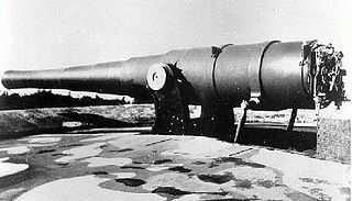
Breakneck Battery is an artillery battery in the British Overseas Territory of Gibraltar. It is located on Ministry of Defence property at the Upper Rock Nature Reserve, north of Lord Airey's Battery. It is one of a dozen batteries in Gibraltar that had 9.2-inch (233.7 mm) guns installed around the turn of the twentieth century. The emplacement features a 9.2-inch Mark X breech-loading gun on a Mark V mounting. The battery was refurbished by 10 Signal Regiment in 2012 and 2016 whilst being on Ceremonial duties whilst the Gibraltar Regiment where on exercise and is one of three surviving 9.2-inch gun emplacements at the Upper Ridge of the Rock of Gibraltar. By the late twentieth century, the 9.2-inch guns in Gibraltar, Bermuda, Portugal, South Africa, and Australia were the remaining examples of an emplacement that at one point had been mounted at strategic locations across the British Empire.

The 3-inch gun M1903 and its predecessors the M1898 and M1902 were rapid fire breech-loading artillery guns with a 360-degree traverse. In some references they are called "15-pounders" due to their projectile weight. They were originally emplaced from 1899 to 1917 and served until shortly after World War II. These 3-inch guns were placed to provide fire to protect underwater mines and nets against minesweepers, and also to protect against motor torpedo boats. In some documentation they are called "mine defense guns". The 3-inch guns were mounted on pedestal mounts that bolted into a concrete emplacement that provided cover and safety for the gun's crew.
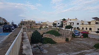
Pembroke Battery was an artillery battery in Pembroke, Malta, Malta. It was built by the British between 1897 and 1899, and most of it was demolished in the 1980s.

West Blockhouse Fort is a mid-19th century coastal artillery fort at West Blockhouse Point, a rocky headland near Dale, Pembrokeshire, to the west of Milford Haven in Wales.

Raleigh Battery is a former coastal artillery battery, built to defend the Royal Naval Dockyard at Devonport.


