The Pennine Alps French: Alpes Pennines, German: Walliser Alpen, Italian: Alpi Pennine, Latin: Alpes Poeninae), sometimes referred to as the Valais Alps, are a mountain range in the western part of the Alps. They are located in Italy and Switzerland (Valais).

The Great St Bernard Pass is the third highest road pass in Switzerland, at an elevation of 2,469 m (8,100 ft). It connects Martigny in the canton of Valais in Switzerland with Aosta in the region Aosta Valley in Italy. It is the lowest pass lying on the ridge between the two highest mountains of the Alps, Mont Blanc and Monte Rosa. It is located on the main watershed that separates the basin of the Rhône from that of the Po.
The Aosta Valley is a mountainous autonomous region in northwestern Italy. It is bordered by Auvergne-Rhône-Alpes, France, to the west, Valais, Switzerland, to the north, and by Piedmont, Italy, to the south and east. The regional capital is Aosta.

Aosta is the principal city of the Aosta Valley, a bilingual region in the Italian Alps, 110 km (68 mi) north-northwest of Turin. It is situated near the Italian entrance of the Mont Blanc Tunnel, at the confluence of the Buthier and the Dora Baltea, and at the junction of the Great and Little St Bernard Pass routes.
Ivrea is a town and comune of the Metropolitan City of Turin in the Piedmont region of northwestern Italy. Situated on the road leading to the Aosta Valley, it straddles the Dora Baltea and is regarded as the centre of the Canavese area. Ivrea lies in a basin that in prehistoric times formed a large lake. Today five smaller lakes—Sirio, San Michele, Pistono, Nero and Campagna—are found in the area around the town.
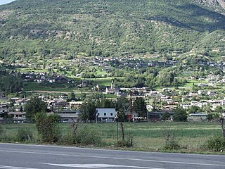
Saint-Christophe is a town and comune in the Aosta Valley. It is located east of Aosta, on the left shore of the Dora Baltea.

Doire was a department of the French Consulate and of the First French Empire in present-day Italy. It was named after the river Dora Baltea. It was formed in 1802, when the Subalpine Republic was directly annexed to France. Its capital was Ivrea.

Dora Baltea or Doire Baltée is a river in northwestern Italy. It is a left-hand tributary of the Po and is about 170 kilometres (110 mi) long.

Saint-Nicolas is a town and comune in the autonomous region of Aosta Valley, in northern Italy. It consists of 13 hamlets located between 950 and 1,550 metres above sea level. Sitting like a balcony above the Dora Baltea Valley, Saint-Nicolas overlooks the four major lateral valleys of the mid-upper Aosta valley. These are ; Val de Cogne, Valsavarenche, Val de Rhêmes, and Valgrisenche.

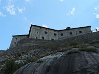
Bard is a town and comune in the Aosta Valley region of northwestern Italy. It is part of the Unité des communes valdôtaines du Mont-Rose and has a population of 134. It is one of I Borghi più belli d'Italia.

Émarèse is a town and comune in the Aosta Valley region of north-western Italy. It has 213 inhabitants.

Val Ferret is the name shared by two valleys separated by the Col Ferret, a pass on the border between Italy and Switzerland. The valleys lie southeast of Mont Blanc Massif. The Swiss valley drains northeast towards Orsières and on into the Rhône basin; whereas the Italian valley drains southwest towards Courmayeur and on into the Po basin.

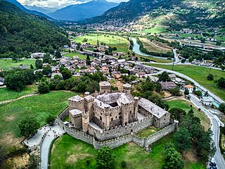
Verrès Castle is a fortified 14th-century castle in Verrès, in the lower Aosta Valley, in north-western Italy. It has been called one of the most impressive buildings from the Middle Ages in the area. Built as a military fortress by Yblet de Challant in the fourteenth century, it was one of the first examples of a castle constructed as a single structure rather than as a series of buildings enclosed in a circuit wall.
The castle stands on a rocky promontory on the opposite side of the Dora Baltea from Issogne Castle. The castle dominates the town of Verrès and the access to the Val d'Ayas. From the outside it looks like an austere cube, thirty metres long on each side and practically free of decorative elements.

The Chiusella valley is a valley in the Province of Turin.

The Cittadella of Alessandria is a star fort and citadel in the city of Alessandria, Italy. It was built in the 18th century by the Kingdom of Sardinia, and today it is one of the best preserved fortifications of that era. It is one of the few fortifications in Europe still in their original environment, since there are no buildings blocking the views of the ramparts, or a road that surrounds the ditches.

Sarriod de la Tour Castle is a castle in the town of Saint-Pierre by the Dora Baltea River, in Northwestern Italy's Aosta Valley. The original castle was typical of the style built between the 10th and 12th centuries, and was greatly expanded by Jean Sarriod in 1420 and his son, Antoine, in 1478. The north wing's ground floor features a wooden-ceilinged "Hall of Heads", named for its decorative motifs.

Cly is a castle in the Italian town of Saint-Denis, overlooking the Dora Baltea river, in Aosta Valley, northwest Italy. It belongs to the so-called primitive style of castle, consisting of a keep with a surrounding wall. The ruins rise from a bed of metamorphic rock, on the edge of a fault line which extends to the Castle of Quart.

The Exilles Fort is a fortified complex in the Susa Valley, Metropolitan City of Turin, Piedmont, northern Italy. Together with the nearby Fort of Fenestrelle and the Forte Albertino it was part of the defensive line between the House of Savoy lands and France: both these states held it in different phases depending on the outcome of the various wars. It is located on a spur commanding one of the narrowest sections of the Susa Valley, along the main road connecting Turin to France.

The siege of Fort Bard was a military action that took place during May 1800 during the second Napoleonic Italian campaign and blocked the advance of Napoleon Bonaparte's Armée de Reserve for 12 days in the narrow passage. Fort Bard was commanded by Captain Josef Stockard von Bernkopf with approximately 300 Austrian troops and 100 Piedmontese soldiers.

Jean-Gaspard Dichat de Toisinge became a general officer in the service of the Kingdom of Sardinia-Piedmont during the War of the First Coalition. Born in the Duchy of Savoy into a distinguished family, he entered the Sardinian army in 1759 and advanced in rank in the peacetime army. After the outbreak of war, he was promoted to lieutenant colonel of the Aosta Infantry Regiment in 1793. That year he became commander of a provisional regiment of grenadiers. In early 1796 he was promoted colonel and later led a division. After another promotion to general officer, he fought against Napoleon Bonaparte's French army at the battles of San Michele and Mondovì and was killed in the latter action.