Fort George was a military fortification in Niagara-on-the-Lake, Ontario, Canada. The fort was used by the British Army, the Canadian militia, and the United States Armed Forces for a brief period. The fort was mostly destroyed during the War of 1812. The site of the fort has been a National Historic Site of Canada since 1921, and features a reconstruction of Fort George.

Fort York is an early 19th-century military fortification in the Fort York neighbourhood of Toronto, Ontario, Canada. The fort was used to house members of the British and Canadian militaries, and to defend the entrance of the Toronto Harbour. The fort features stone-lined earthwork walls and eight historical buildings within them, including two blockhouses. The fort forms a part of Fort York National Historic Site, a 16.6 ha (41-acre) site that includes the fort, Garrison Common, military cemeteries, and a visitor centre.

Fort Mackinac is a former British and American military outpost garrisoned from the late 18th century to the late 19th century in the city of Mackinac Island, Michigan, on Mackinac Island. The British built the fort during the American Revolutionary War to control the strategic Straits of Mackinac between Lake Michigan and Lake Huron, and by extension the fur trade on the Great Lakes. The British did not relinquish the fort until thirteen years after the end of the American Revolutionary War. Fort Mackinac later became the scene of two strategic battles for control of the Great Lakes during the War of 1812. During most of the 19th century, it served as an outpost of the United States Army. Closed in 1895, the fort has been adapted as a museum on the grounds of Mackinac Island State Park.
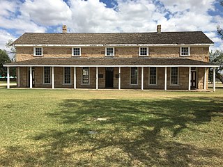
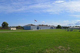
Fort Concho is a former United States Army installation and National Historic Landmark District located in San Angelo, Texas. It was established in November 1867 at the confluence of the North and South Concho Rivers, on the routes of the Butterfield Overland Mail Route and Goodnight–Loving Trail, and was an active military base for the next 22 years. Fort Concho was the principal base of the 4th Cavalry from 1867 to 1875 and then the "Buffalo Soldiers" of the 10th Cavalry from 1875 to 1882. The troops stationed at Fort Concho participated in Ranald S. Mackenzie's 1872 campaign, the Red River War in 1874, and the Victorio Campaign of 1879–1880.

Fort Mifflin, originally called Fort Island Battery and also known as Mud Island Fort, was commissioned in 1771 and sits on Mud Island on the Delaware River below Philadelphia, Pennsylvania near Philadelphia International Airport.
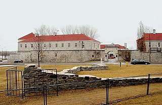
Fort Frontenac was a French trading post and military fort built in July 1673 at the mouth of the Cataraqui River where the St. Lawrence River leaves Lake Ontario, in a location traditionally known as Cataraqui. It is the present-day location of Kingston, Ontario, Canada. The original fort, a crude, wooden palisade structure, was called Fort Cataraqui but was later named for Louis de Buade de Frontenac, Governor of New France who was responsible for building the fort. It was abandoned and razed in 1689, then rebuilt in 1695.

Fort Laramie was a significant 19th-century trading post, diplomatic site, and military installation located at the confluence of the Laramie and the North Platte Rivers. They joined in the upper Platte River Valley in the eastern part of the present-day U.S. state of Wyoming. The fort was founded as a private trading-post in the 1830s to service the overland fur trade; in 1849, it was purchased by the United States Army. The site was located east of the long climb leading to the best and lowest crossing-point over the Rocky Mountains at South Pass and became a popular stopping-point for migrants on the Oregon Trail. Along with Bent's Fort on the Arkansas River, the trading post and its supporting industries and businesses were the most significant economic hub of commerce in the region.

Lake Superior State University is a public college in Sault Ste. Marie, Michigan. It enrolls approximately 2,000 students. Due to its proximity to the Canadian border, LSSU has many Canadian students and offers joint programs with Sault College and Algoma University in the twin city of Sault Ste. Marie, Ontario, Canada across the St. Marys River. In a sign of this close relationship with its international neighbor, LSSU flies both the Canadian and United States flags on its campus.

Fort Wayne is located in the city of Detroit, Michigan, at the foot of Livernois Avenue in the Delray neighborhood. The fort is situated on the Detroit River at a point where it is under half a mile to the Ontario shore. The original 1848 limestone barracks still stands, as does the 1845 fort. On the grounds but outside the original fort are additional barracks, officers quarters, a recreation building, a theater, commissary, guard house, garage, and stables. A large warehouse and the post fire station were torn down in 1976 and the two-story hospital was torn down in 2007.

Fort Yellowstone was a U.S. Army fort, established in 1891 at Mammoth Hot Springs in Yellowstone National Park. Yellowstone was designated in 1872 but the Interior Department was unable to effectively manage the park. Administration was transferred to the War Department in August 1886 and General Philip Sheridan sent a company of cavalry to Mammoth Hot Springs to build a cavalry post. The army originally called the post Camp Sheridan in honor of General Sheridan but the name was changed to Fort Yellowstone in 1891 when construction of the permanent fort commenced. The army administered the park until 1918 when it was transferred to the newly created National Park Service. The facilities of Fort Yellowstone now comprise the Yellowstone National Park headquarters, the Horace Albright Visitor Center and staff accommodations.

Fort Winnebago was a 19th-century fortification of the United States Army located on a hill overlooking the eastern end of the portage between the Fox and Wisconsin Rivers east of present-day Portage, Wisconsin. It was the middle one of three fortifications along the Fox-Wisconsin Waterway that also included Fort Howard in Green Bay, Wisconsin and Fort Crawford in Prairie du Chien, Wisconsin. Fort Winnebago was constructed in 1828 as part of an effort to maintain peace between white settlers and the region's Native American tribes following the Winnebago War of 1827. The fort's location was chosen not only because of its proximity to the site of Red Bird's surrender in the Winnebago War, but also because of the strategic importance of the portage on the Fox-Wisconsin Waterway, a heavily traveled connection between the Great Lakes and the Mississippi River. Fort Winnebago's location near the portage allowed it to regulate transportation between the lakes and the Mississippi.

Fort Wilkins Historic State Park is a historical park operated by the Michigan Department of Natural Resources at Copper Harbor, Michigan. The park preserves the restored 1844 army military outpost, Fort Wilkins, which was placed on the National Register of Historic Places in 1970. The state park's 700 acres (280 ha) include camping and day-use facilities as well as the Copper Harbor Lighthouse, built in 1866. The park is a "Cooperating Site" of the Keweenaw National Historical Park.

Fort Buford was a United States Army Post at the confluence of the Missouri and Yellowstone rivers in Dakota Territory, present day North Dakota, and the site of Sitting Bull's surrender in 1881.

Fort Dalles was a United States Army outpost located on the Columbia River at the present location of The Dalles, Oregon, in the United States. Built when Oregon was a territory, the post was used mainly for dealing with wars with Native Americans. The post was first known as Camp Drum and then Fort Drum.

Fort Whipple is a former United States (U.S.) Army post that was temporarily established at Del Rio Springs, north of present day Chino Valley, Arizona, and later relocated to a permanent site near present day Prescott, Arizona.

Fort Totten State Historic Site is a historic fort that sits on the shores of Devils Lake near Fort Totten, North Dakota. During its 13 years of operation as a fort, Fort Totten was used during the American Indian wars to enforce the peace among local Native American tribes and to protect transportation routes. After its closing in 1890, it operated until 1959 as a Native American boarding school, called the Fort Totten Indian Industrial School. It was added to the National Register of Historic Places in 1971; in its nomination form, the State Historical Society of North Dakota called it "one of the best preserved military posts... in the Trans-Mississippi West for the Indian Wars period".

Fort Sanders was a wooden fort constructed in 1866 on the Laramie Plains in southern Wyoming, near the city of Laramie. Originally named Fort John Buford, it was renamed Fort Sanders after General William P. Sanders, who died at the Siege of Knoxville during the American Civil War. This was the second fort to be named after Sanders, the first being in Knoxville, Tennessee. The fort was originally intended to protect travelers on the nearby Overland Trail from Indian attacks, but later the garrison was tasked with protecting the workers of the Union Pacific railroad when it arrived in the spring of 1868. In 1869 the town of Laramie was created about 3 miles (4.8 km) north of the fort. Fort Sanders became less important following the construction of Fort D. A. Russell in Cheyenne in 1868, but the War Department maintained it until 1882 when the buildings were sold.

The "Old Stone Barracks" is the last remaining structure of a proposed quadrangle of early U.S. Army barracks built at Plattsburgh, New York in 1838. Of the four main buildings initially planned for the Plattsburgh post, only two were ever constructed, an officer's barracks and an enlisted barracks which formed an "L" shape. The buildings were utilized by the Army for nearly a century. The officer's quarters, in which Lt. Ulysses S. Grant once stayed, was torn down by the U.S. Air Force during the winter of 1963. The remaining building, the 200-foot (61 m) long, two story "Old Stone Barracks," remained mostly empty after the early 1960s and was added to the National Register of Historic Places in 1971. In December 2010 the Barracks and more than 7 acres of property was offered to a Canadian real estate developer for $35,000 with the intention of building an apartment complex on the historic site. At the time, the Barracks property was appraised at over $775,000 and the sale sparked public outcry for its preservation. In 2014, the building was again sold to current owners Terry Schmaltz and Mary Theresa Pearl who redeveloped it as the home of the "Valcour Brewing Company." The new craft brewery opened in 2016.
Fort Drummond, also known as Fort Colyer or Fort Collier, is a military fort located on the west end of Drummond Island on Whitney Bay, in the vicinity of De Tour Village, Michigan. It is the only known military and civilian site established by British forces on American soil following the War of 1812. It was listed on the National Register of Historic Places in 1969 and designated a Michigan State Historic Site in 1956.

Fort Apache Historic Park is a tribal historic park of the White Mountain Apache, located at the former site of Fort Apache on the Fort Apache Indian Reservation. The park interprets the rich and troubled history of relations between the Apache and other Native American tribes at the fort, which was converted into a Bureau of Indian Affairs boarding school after its military use ended. The park, which covers 288 acres (117 ha) of the former fort and school, as well as a nearby military cemetery, form the National Historic Landmark Fort Apache and Theodore Roosevelt School historic district.